GNSS positioning using pressure sensors

a technology of pressure sensor and positioning position, applied in the direction of fluid pressure measurement, navigation instruments, instruments, etc., to achieve the effect of augmenting the gnss position

Inactive Publication Date: 2010-08-12
QUALCOMM INC
View PDF56 Cites 50 Cited by
  • Summary
  • Abstract
  • Description
  • Claims
  • Application Information

AI Technical Summary

Benefits of technology

[0019]Embodiments of the invention further relate to a method for multipath mitigation, comprising receiving a GNSS measurement; calculating a position based on the GNSS measurement; receiving a first position-related datum derived from a physical sensor input and corresponding approximately in time to the GNSS measurement; determining whether the position based on the GNSS measurement was significantly affected by multi path by using the first position-related datum The method can be extended to include situations wherein the step of determining whether the position based on the GNSS measurement was significantly affected by multipath further comprises using a second position-related datum derived from the physical sensor input and corresponding to a time previous to the time of the GNSS measurement. Furthermore, the method can be performed such that the step of determining whether the position based on the GNSS measurement was significantly affected by multipath comprises computing a difference between the first position-related datum and the second position-related datum. Preferably, the first position related datum is an altitude or an acceleration and optionally the altitude is calculated using an atmospheric model.
[0020]In certain embodiments, the method will further comprise the step of

Problems solved by technology

Further, the navigation receiver may be so configured that the altitude derived from the GNSS rece

Method used


Image

  • GNSS positioning using pressure sensors
  • GNSS positioning using pressure sensors
  • GNSS positioning using pressure sensors

Examples


Embodiment Construction

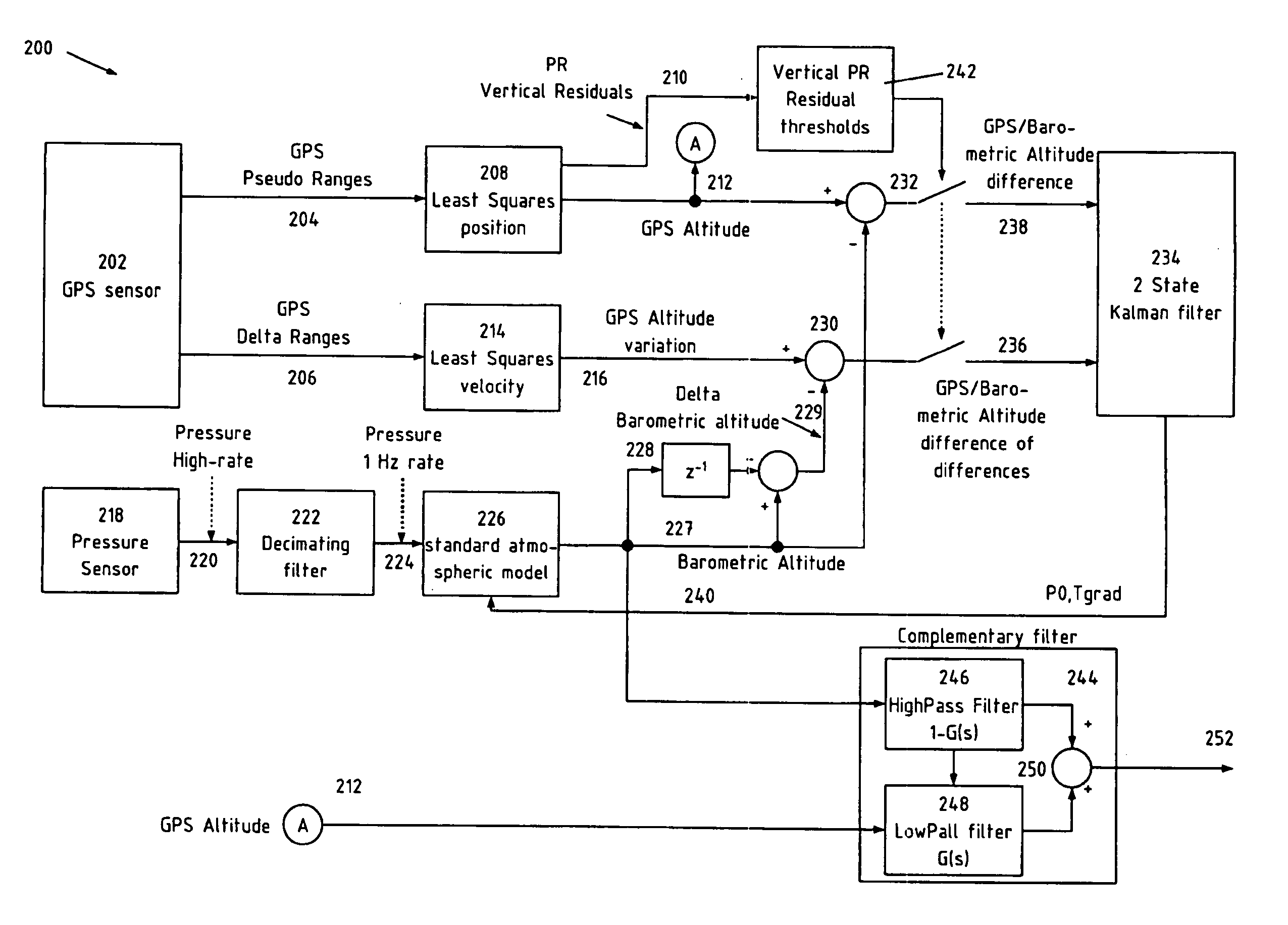
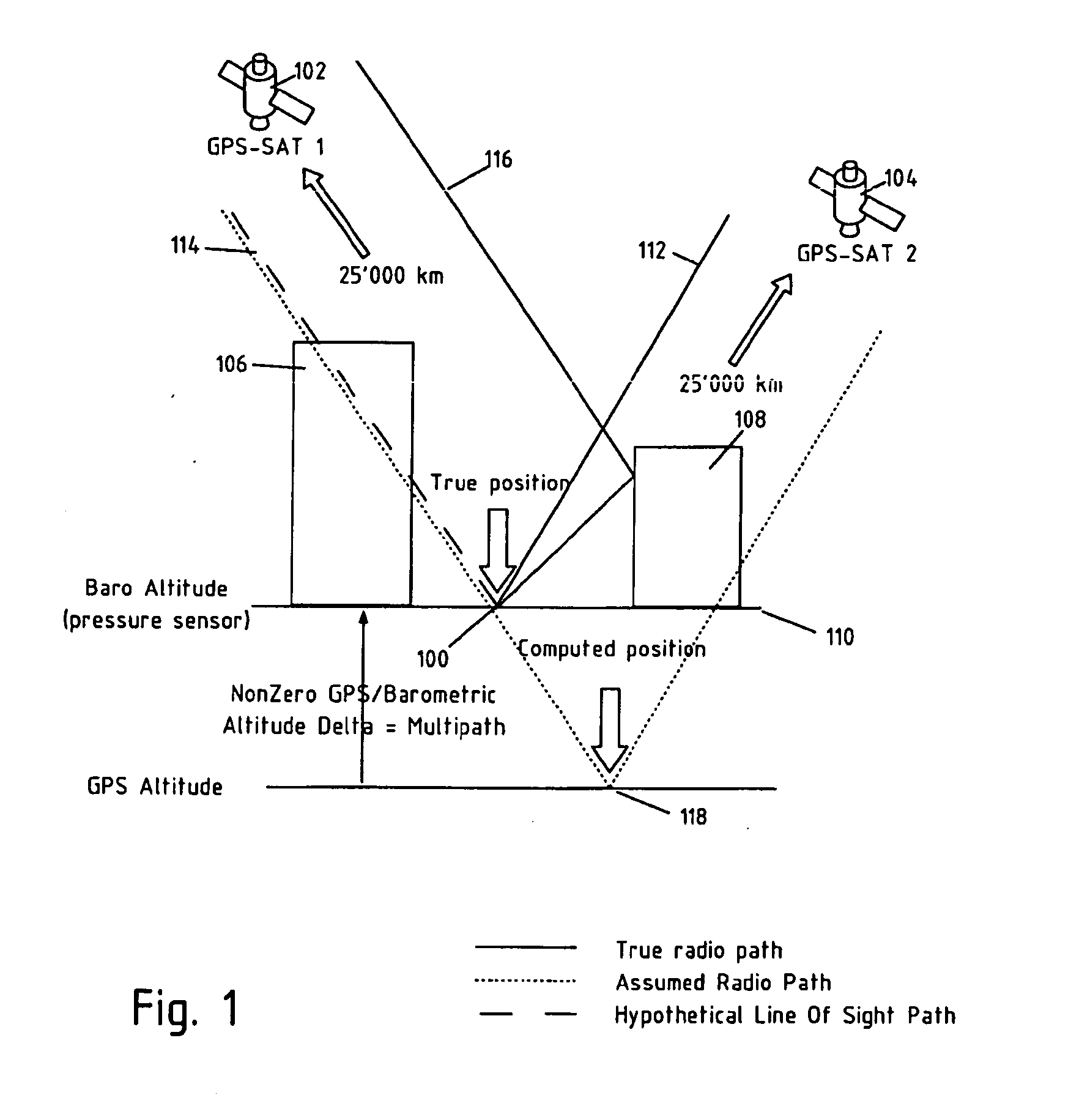
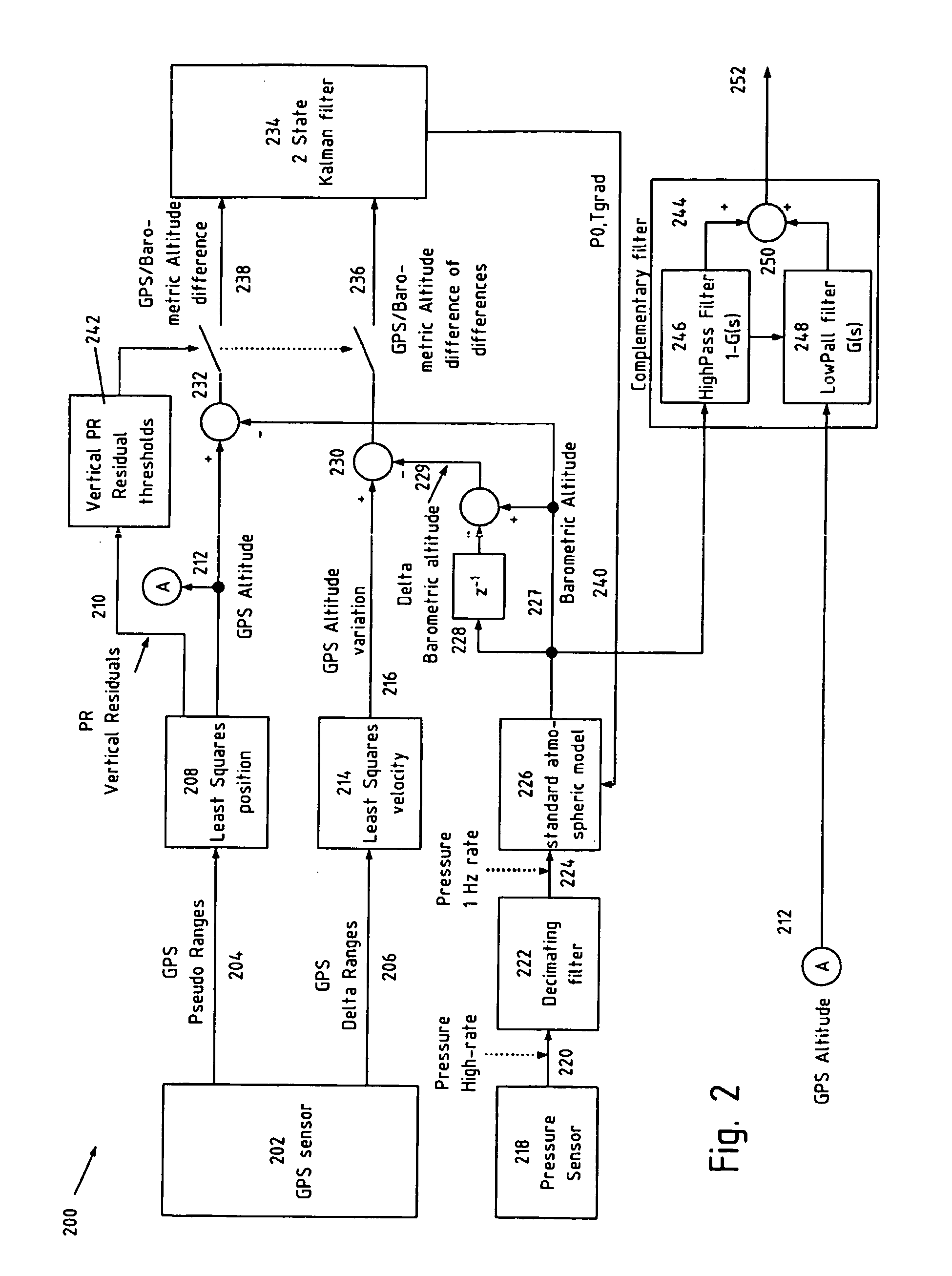
[0028]Numerous embodiments of the present invention relate to improving the accuracy of position fixes and the concept of “multi path mitigation” in navigation systems. As used herein, “multipath mitigation” means a lessening of detrimental effects of multipath signals.

[0029]In general, embodiments of the invention accomplish improved accuracy and multipath mitigation by using information, which may be any kind of information, usually encoded as a digital or analog signal, derived from a sensor that provides information from a source other than the primary GNSS system being used for position fixes. For example, if the sensor is provided to supplement a Galileo receiver, the sensor may be based on a GPS receiver. Here, the term “derived from” means “retrieved as the direct output of’ or “modified from the output of’. The sensor may also be a “physical sensor”. A physical sensor is a device that senses the more immediate physical environment of the receiver, as opposed to a sensor tha...


PUM


Abstract

Systems, methods and devices for improving the accuracy of GNSS data are provided. Specifically, embodiments of the invention can advantageously use sensor input to improve the accuracy of position fixes. The use of physical sensors in navigation systems is deemed particularly advantageous, especially where altitude data derived from the pressure sensor is calibrated with and/or blended with GNSS altitude data.

Description

BACKGROUND OF THE INVENTION[0001]The embodiments of the present invention relate generally to the improvement of GNSS data using altitude data derived from a pressure sensor. Certain embodiments use pressure-sensor derived data as calibrated by GNSS data and / or as blended with GNSS data to provide an improved altitude determination.[0002]Further embodiments of the invention generally relate to detection, use and / or mitigation of multipath signals for communication and especially navigation systems. Certain embodiments further relate to the detection, use and or mitigation of multipath signals for GNSS systems.[0003]There is currently a need for improved accuracy of GNSS positioning in particular with respect to portable navigation devices providing mapping services to users. Currently, GNSS horizontal accuracy is not sufficient to provide an accurate user map location without using “map matching” techniques—that is, without guessing a user location based on the position of roads and...

Claims


Application Information

Patent Timeline
IPC IPC(8): G01S19/45G01C21/26G01S5/14G01S19/22
CPCG01S19/45G01S19/22G01C5/005G01L19/08
Inventor GARIN, LIONEL J.
Owner QUALCOMM INC
Why Eureka
Try Eureka