Method and apparatus for precise relative positioning in multiple vehicles

a technology for determining the position and velocity of multiple vehicles, applied in direction finders, instruments, measurement devices, etc., can solve the problems of excess bandwidth wastage, the general limit of pseudo-range measurements to about 15 meters, and the bandwidth required to do this

Inactive Publication Date: 2010-09-30
GM GLOBAL TECH OPERATIONS LLC
View PDF5 Cites 21 Cited by
  • Summary
  • Abstract
  • Description
  • Claims
  • Application Information

AI Technical Summary

Benefits of technology

[0007]In accordance with the teachings of the present invention, a system and method are disclosed for determining the position and velocity of a plurality of vehicles relative to a host vehicle using GPS information. The method includes building a graph of the vehicles that define weighted baselines between each of the vehicles and the host vehicle and each of the vehicles where the weighted baselines define a geometric dilution of precision between the vehicles. The method then determines the optimal baseline having the lowest geometric dilution of precision between the host vehicle and each of the other vehicles using the weighted baselines based on the geometric dilution of precision. The method then computes the relative position and velocity between all of the vehicles and the host vehicle using the optimal baselines.

Problems solved by technology

The bandwidth required to do this will be an issue in a crowded traffic scenario where a large number of vehicles are involved.
However, the pseudo-range measurements are generally limited to about ±15 meters.
It is thus noted that excess bandwidth wastage occurs if the RTCM protocol is directly used in a cooperative safety system.

Method used


Image

  • Method and apparatus for precise relative positioning in multiple vehicles
  • Method and apparatus for precise relative positioning in multiple vehicles
  • Method and apparatus for precise relative positioning in multiple vehicles

Examples


Embodiment Construction

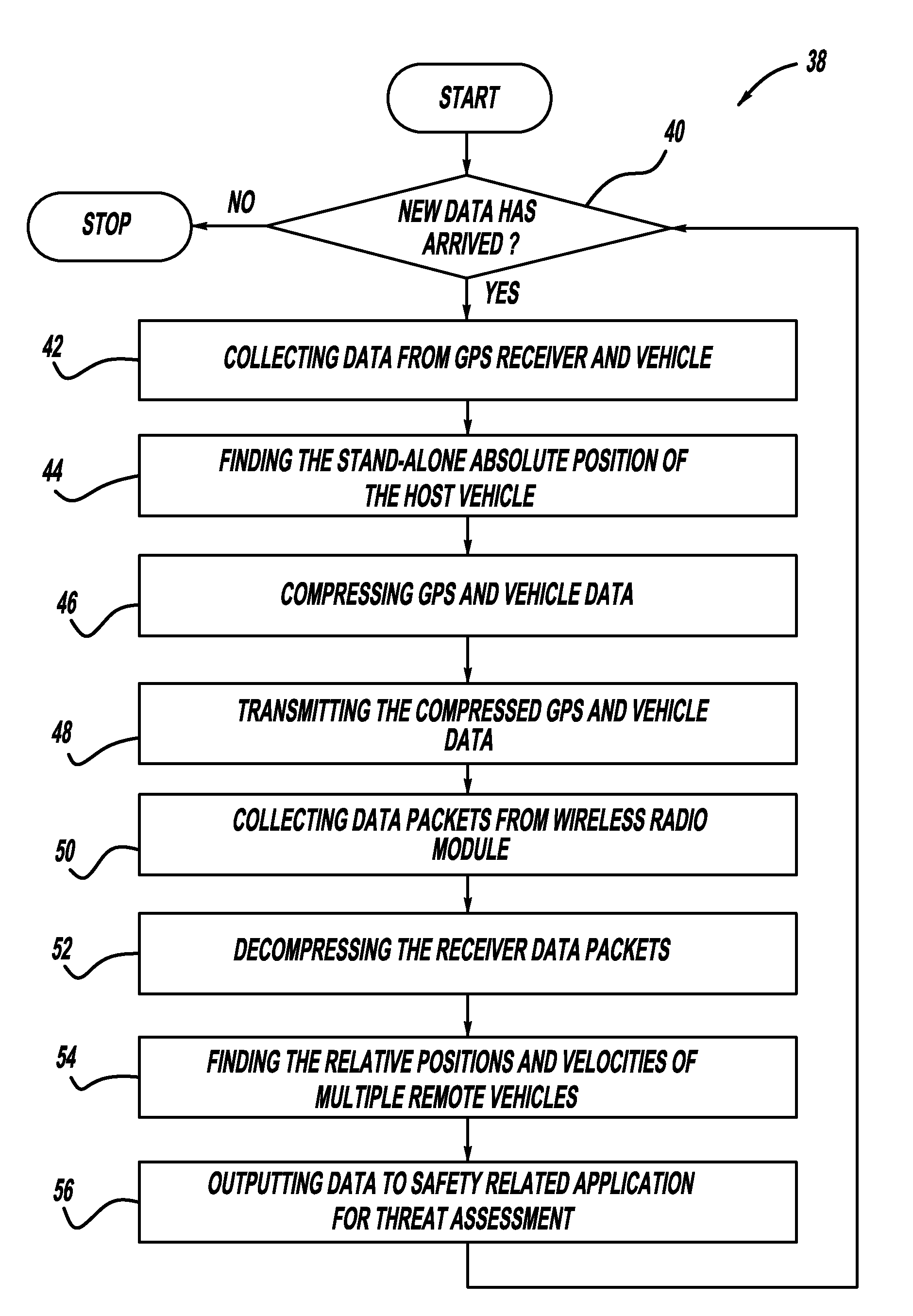
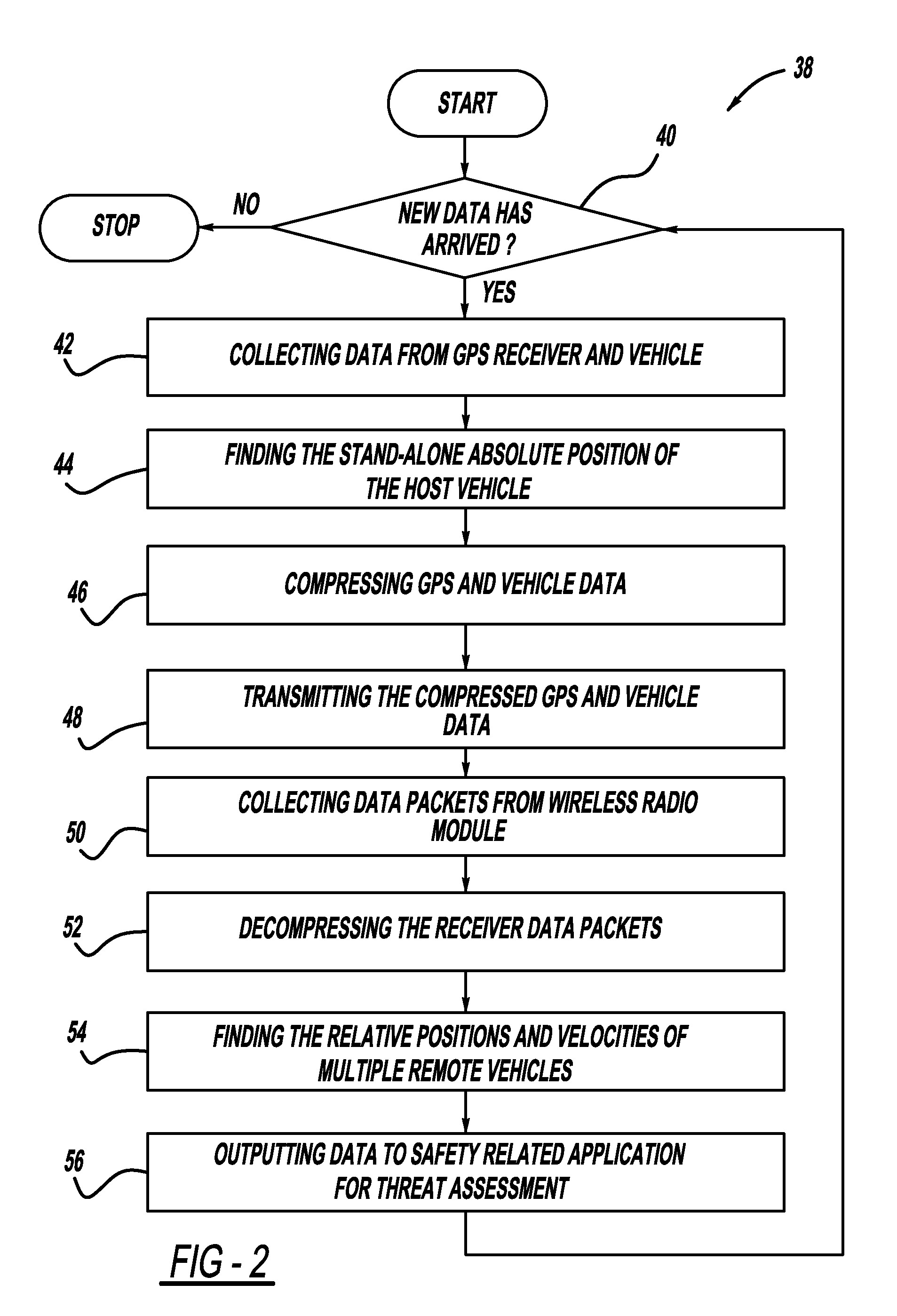
[0023]The following discussion of the embodiments of the invention directed to a system and method for determining the position and velocity of a plurality of vehicles relative to a host vehicle using GPS signals and optimal-spanning tree analysis is merely exemplary in nature, and is in no way intended to limit the invention or it's applications or uses.

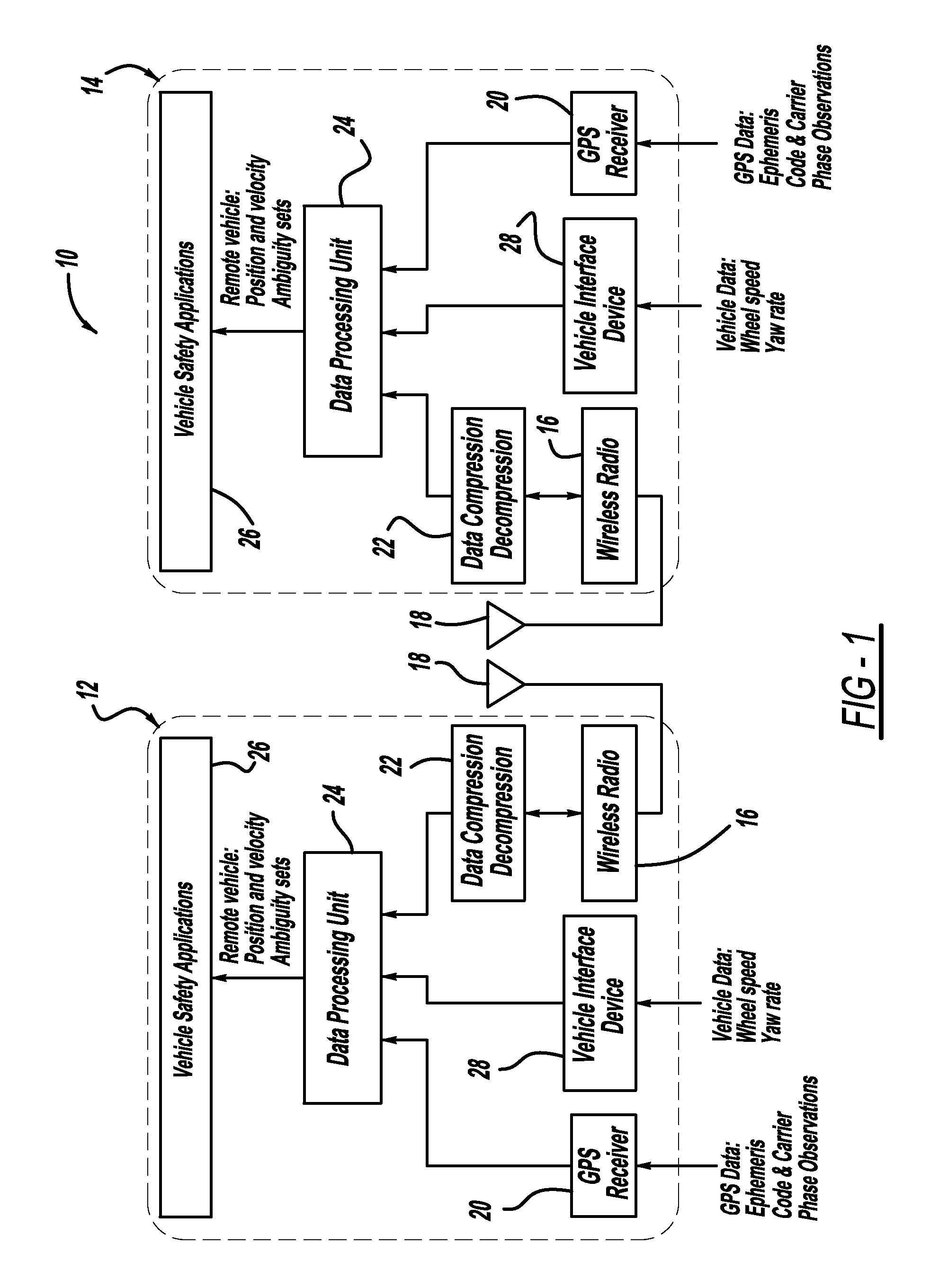
[0024]FIG. 1 illustrates a communications architecture 10 for a host vehicle 12 and a remote vehicle 14. The host vehicle 12 and the remote vehicle 14 are each equipped with a wireless radio 16 that includes a transmitter and a receiver (or transceiver) for broadcasting and receiving wireless packets through an antenna 18. Each vehicle includes a GPS receiver 20 that receives satellite ephemeris, code range, carrier phase and Doppler frequency shift observations. Each vehicle also includes a data compression and decompression unit 22 for reducing the communication bandwidth requirement. Each vehicle also includes a data processing u...


PUM


Abstract

A system and method for determining the position and velocity of a plurality of vehicles relative to a host vehicle using GPS data. The method includes building a graph of the vehicles that define weighted baselines between each of the vehicles and the host vehicle and each of the vehicles where the weighted baselines define a geometric dilution of precision between the vehicles. The method then determines the optimal baseline between the host vehicle and each of the other vehicles using the weighted baselines based on the lowest geometric dilution of precision. The method then computes the relative position and velocity between all of the vehicles and the host vehicle using the optimal baselines.

Description

BACKGROUND OF THE INVENTION[0001]1. Field of the Invention[0002]This invention relates generally to a system and method for determining the position and velocity of a plurality of vehicles relative to a host vehicle and, more particularly, to a system and method for determining the position and velocity of a plurality of vehicles relative to a host vehicle using GPS signals, where the system calculates optimal baselines between the vehicles.[0003]2. Discussion of the Related Art[0004]Short-baseline precise relative positioning of multiple vehicles has numerous civilian applications. By using relative GPS signals in real-time, a vehicle can establish a sub-decimeter level accuracy of relative positions and velocities of surrounding vehicles (vehicle-to-vehicle object map) that are equipped with a GPS receiver and a data communication channel, such as a dedicated short range communications (DSRC) channel. This cooperative safety system can provide position and velocity information in ...

Claims


Application Information

Patent Timeline
Patent Type & Authority Applications(United States)
IPC IPC(8): G01S19/51
CPCG01S5/0072G01S19/51G01S5/0289
Inventor ZENG, SHUQING
Owner GM GLOBAL TECH OPERATIONS LLC
Why Eureka
Try Eureka