System and Method For Planning A Drilling Operation

a drilling operation and planning system technology, applied in the field of system and method for planning a drilling operation, can solve the problems of inefficiency, lack of tools and interactivity, and sequential well design practices, and lack of dynamic data integration capabilities of existing work processes and software tools,

Active Publication Date: 2011-06-23
EXXONMOBIL UPSTREAM RES CO
View PDF91 Cites 123 Cited by
  • Summary
  • Abstract
  • Description
  • Claims
  • Application Information

AI Technical Summary

Benefits of technology

[0029]While the present disclosure is susceptible to various modifications and alternative forms, specific example embodiments thereof have been shown in the drawings and are herein described in detail. It should be understood, however, that the description herein of specific example embodiments is not intended to limit the disclosure to the particular forms disclosed herein, but on the contrary, this disclosure is to cover all modifications and equivalents as defined by the appended claims. It should also be understood that the drawings are not necessarily to scale, emphasis instead being placed upon clearly illustrating principles of exemplary embodiments of the present invention. Moreover, certain dimensions may be exaggerated to help visually convey such principles.

Problems solved by technology

In general, existing work processes and software tools lack the dynamic data integration capabilities required for interactive, cross-functional analysis and field development and management decisions.
Current well design practices are often sequential, inefficient, and lack the tools and interactivity to adequately optimize a well design given a complex and uncertain three-dimensional distribution of possible reservoir intervals and drilling obstacles (hazards).
A drawback of existing three-dimensional visualization techniques is that they generally lack sufficient data to provide satisfactory results.
While the use of three-dimensional visualization tools to screen target locations is not uncommon, in many cases this step is bypassed because of the insufficiency of the data.
The rock and fluid property information can come from a wide variety of sources including nearby well bores and predictive models, but it is typically difficult for drilling engineers to obtain and input into their analysis software.
In such a case the engineer can only reuse the information to a very limited extent when evaluating a new well design.
This analysis can result in the identification of issues that may also necessitate additional changes to the target location(s), number of targets, or basic trajectory parameters, thereby adding additional iterations and time to design the final well path.
The results of the well design and analysis typically indicate potential issues with the well as originally conceived and may necessitate changes to the target location(s), number of targets, or basic trajectory parameters.
The length of time taken to iterate between target selection and detailed well design can limit the number of scenarios examined and lead to sub-optimal results.
While recent integration of three-dimensional planning methods have improved the efficiency of the target selection and well path planning work processes, significant inefficiencies and challenges remain.
The variability of individual reservoir intervals and the complex arrangement of multiple reservoirs within a three-dimensional volume of the earth create an inherent complexity difficult to manage using existing tools.
Defining the penetration point(s) or segment(s) for individual wells or groups of wells using a process of iteratively selecting and screening individual target points is inefficient, time consuming and leads to sub-optimal reservoir performance.
The amount and complexity of the data to be analyzed and visualized exceeds the capacity of the user and the integration capabilities of current visualization systems.
Even with these methods the visualization and analysis of relevant data for target selection and well path design or analysis is extremely difficult and time consuming.
Because drilling target selection and the evaluation of resulting well trajectories is a highly iterative process, the use of three-dimensional subsurface volumes for the purpose of drilling target selection and well path design and evaluation has so far been relatively limited.
In cases where geologists and engineers do use three-dimensional subsurface volumes for the purpose of drilling target selection and well path design, the amount of time involved in setting up the desired displays limits the number of target combinations / trajectories evaluated.
As a result, a significant amount of time is spent inefficiently and the final selected targets and well trajectories may be sub-optimal.

Method used


Image

  • System and Method For Planning A Drilling Operation
  • System and Method For Planning A Drilling Operation
  • System and Method For Planning A Drilling Operation

Examples


Embodiment Construction

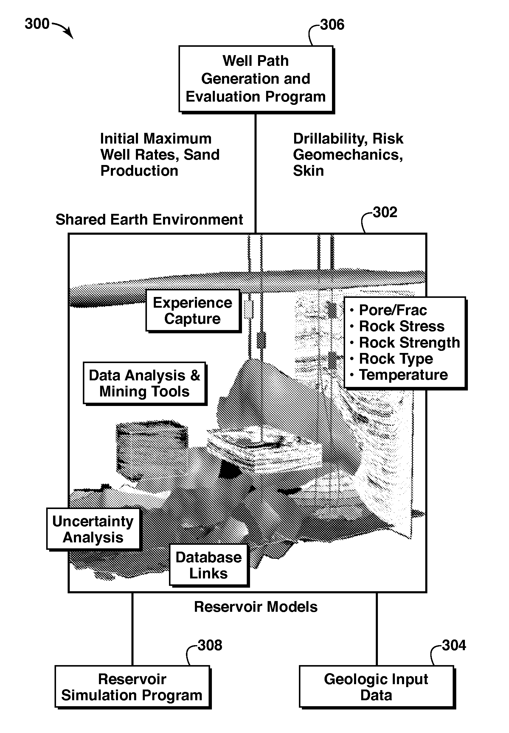
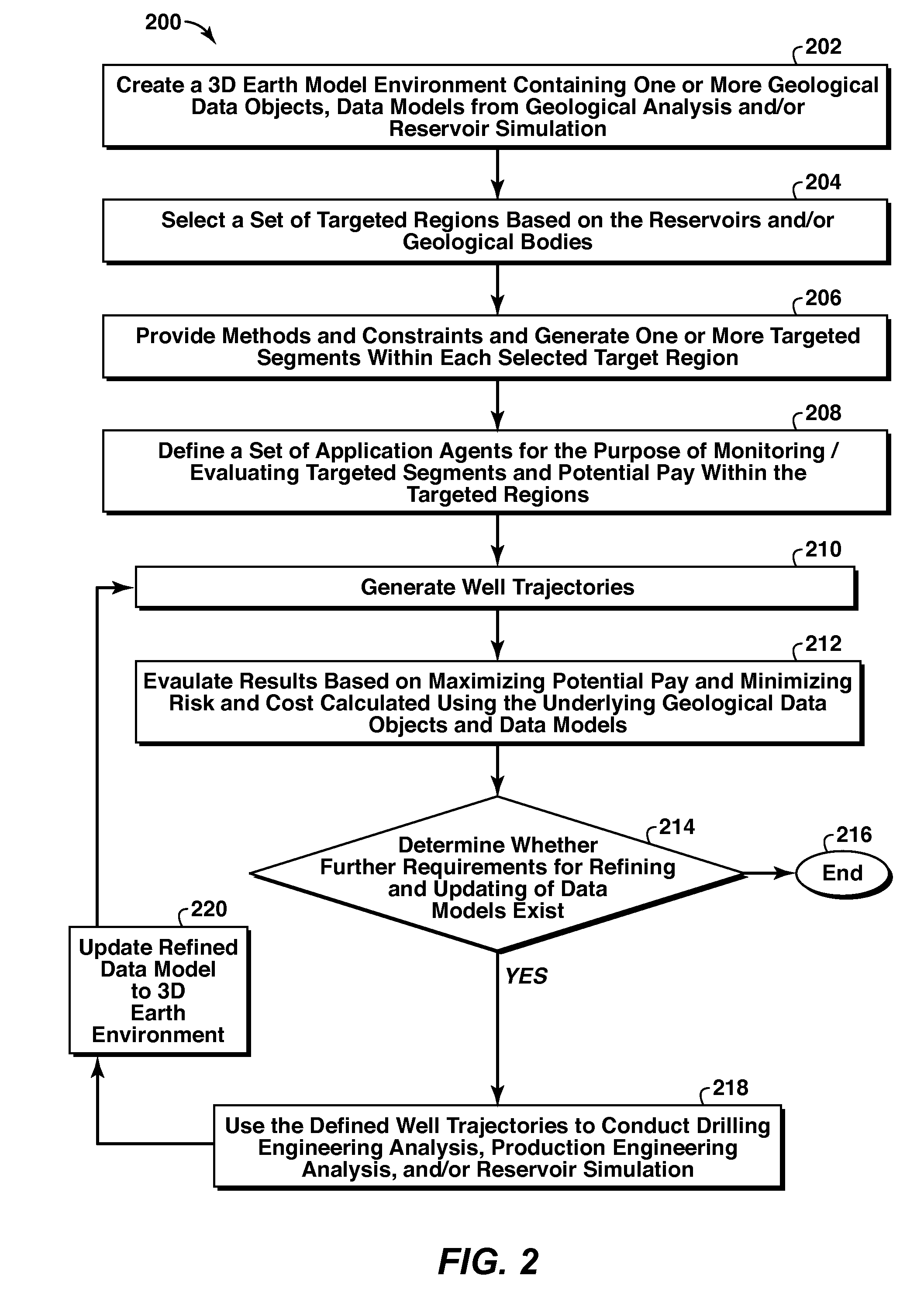
[0030]An exemplary embodiment of the present invention relates to providing tools and technologies to enable geoscience and engineering teams to more effectively utilize computing and networking technology to manage assets. These efforts include creating an interactive work environment within which multi-dimensional data can be displayed, explored, and analyzed to facilitate cross-functional decision making Applications within this environment may include: remote geo-steering of wells as they are drilled; real-time update of log and well test information for rapid update of reservoir models and development drilling plans, monitoring of pressure and flow data from instrumented wells, production and work optimization and the like.

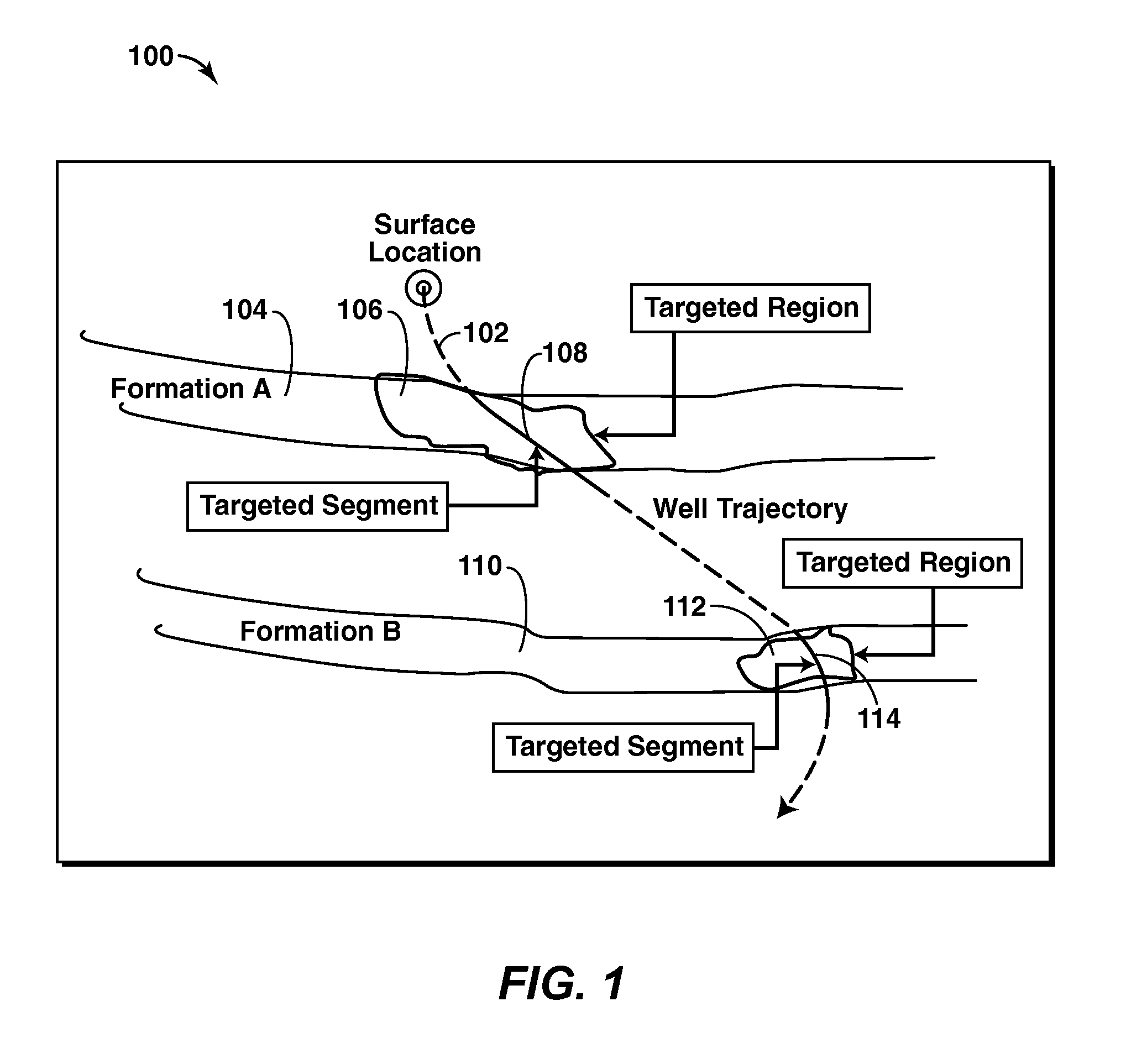
[0031]In one exemplary embodiment of the present invention, a well planning and screening process is facilitated by creating an interactive three-dimensional environment in which the user can move beyond traditional target and path definition methods (i.e., d...


PUM


Abstract

A method of planning a drilling operation IS provided that comprises selecting a set of targeted regions based on data from a three-dimensional shared earth model and generating at least one targeted segment within each one of the set of targeted regions The method further comprises defining at least one application agent for the purpose of evaluating the at least one targeted segment within each one of the set of targeted regions based on a potential payout in terms of production of hydrocarbons The exemplary method additionally comprises identifying at least one well trajectory through the at least one targeted segment within each one of the set of targeted regions And the method comprises employing the at least one application agent to evaluate well trajectories based on the potential payout in terms of at least one of production of hydrocarbons, drilling complexity, cost or stability of well planning

Description

CROSS-REFERENCE TO RELATED APPLICATION[0001]This application claims the benefit of U.S. Provisional Patent Application 61 / 111,981 filed 6-Nov.-2008 entitled SYSTEM AND METHOD FOR PLANNING A DRILLING OPERATION, the entirety of which is incorporated by reference herein.FIELD OF THE INVENTION[0002]Exemplary embodiments of the present invention relate to a system and method for planning a drilling operation. In particular, an exemplary embodiment of the present invention is associated with defining optimal target locations and well trajectory plans within a three dimensional shared earth model.BACKGROUND OF THE INVENTION[0003]This section is intended to introduce various aspects of the art, which may be associated with exemplary embodiments of the present invention. This discussion is believed to assist in providing a framework to facilitate a better understanding of particular aspects of the present invention. Accordingly, it should be understood that this section should be read in thi...

Claims


Application Information

Patent Timeline
Patent Type & Authority Applications(United States)
IPC IPC(8): G06G7/48
CPCE21B47/022E21B49/00E21B41/0092E21B44/00E21B41/00
Inventor HOLL, JAMES E.CHENG, YAO-CHOUCZERNUSZENKO, MAREKMUSUM, RUNESEQUEIRA, JOSEBRAAKSMA, HENDRIK
Owner EXXONMOBIL UPSTREAM RES CO
Why Eureka
Try Eureka