Method and interface for displaying locations associated with annotations

a technology of annotations and interfaces, applied in probabilistic networks, instruments, pulse techniques, etc., can solve the problems of ineffective network services, limiting solutions, and time-consuming and less accurate processes

Active Publication Date: 2011-07-14
VERIZON PATENT & LICENSING INC
View PDF29 Cites 30 Cited by
  • Summary
  • Abstract
  • Description
  • Claims
  • Application Information

AI Technical Summary

Benefits of technology

In particular embodiments, the present invention provides methods, systems and computer program products for displaying geographical locations associated with one or more annotations. In a particular embodiment, a language model is used to obtain the probability distribution of the locations over one or more annotations. Further, the system and the method utilizes the probability data obtained from the language model to determine a probability score for each location over the one or more annotations. Subsequently, one or more geographical locations are displayed on a...

Problems solved by technology

However, this process is time consuming and less accurate than automatic geo-tagging.
However, these solutions are limiting as they assume the prior knowledge of the location through the information appended with the content objects and usually limit th...

Method used


Image

  • Method and interface for displaying locations associated with annotations
  • Method and interface for displaying locations associated with annotations
  • Method and interface for displaying locations associated with annotations

Examples


Embodiment Construction

Various embodiments of the present invention will be described in detail below with reference to accompanying drawings. It will be apparent, however, that these embodiments may be practiced without some or all of these specific details. In other instances, well known process steps or elements have not been described in detail in order not to unnecessarily obscure the description of the invention. The following example embodiments and their aspects are described and illustrated in conjunction with apparatuses, methods, and systems which are meant to be illustrative examples, not limiting in scope.

Example Network Environment

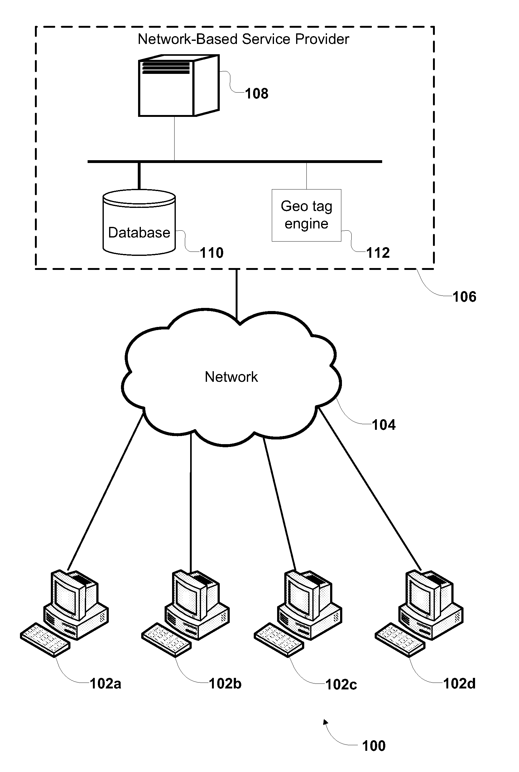
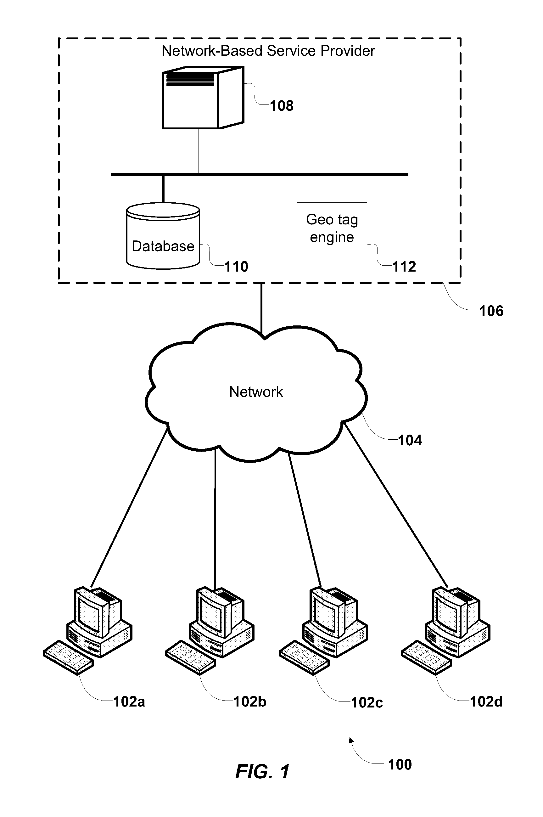
FIG. 1 illustrates an implementation of a network environment 100 in which various implementations of the invention may be deployed, according to one embodiment. Network environment 100 includes a network-based service provider 106, a network 104, and one or more remote clients 102. Network 104 generally represents one or more interconnected networks, over which ne...


PUM


Abstract

Methods, systems and computer program products for displaying geographical locations with the one or more annotations. In a particular embodiment, a language model is used to obtain the probability distribution of the locations over one or more annotations. Further, the system and the method utilizes the probability data obtained from the language model to determine a probability score for each location over the one or more annotations. Subsequently, one or more geographical locations are displayed on a world map, based on the probability score of the geographical locations over the one or more annotations. In one embodiment, geographical locations may be highlighted using a color code on a heat map overlaid on the world map. The color code may represent the ranking of the geographical locations based on the calculated probability score for each identified geographical location. Further, when the user provides one or more additional annotations, the world map may be dynamically updated to display the relevant geographical locations associated with the updated annotations.

Description

TECHNICAL FIELDThe present disclosure generally relates to display of one or more geographical locations, on a world map, associated with one or more annotations.BACKGROUNDThe internet has gradually evolved to offer a wide range of network services for online sharing and management of user generated content objects. Such network services allow a user to share and browse content objects such as multimedia content objects, audio content objects, visual content objects, and text content objects. Some examples of such services are Panoramio™, Blogger™ and Flickr™.Network services are leading the growing enthusiasm for personal location awareness by allowing the user to spatially organize and browse their personal content objects. Users want to geo-tag their personal content objects and further represent the content objects on a world map. Geo-tagging is the process of attaching location information such as latitude and longitude coordinates to content objects. Geo-tagged content objects...

Claims


Application Information

Patent Timeline
IPC IPC(8): G06N5/02G06F3/048G09G5/00
CPCG06N7/005G06F17/30268G06F17/30241G06F16/29G06F16/5866G06N7/01G06F40/169
Inventor VAN ZWOL, ROELOFMURDOCK, VANESSAGARCIA PUEYO, LLUIS
Owner VERIZON PATENT & LICENSING INC
Why Eureka
Try Eureka