Global navigation satellite system (GNSS) reference station integrity monitoring and assurance

a technology of global navigation satellite system and reference station, which is applied in satellite radio beaconing, measurement devices, instruments, etc., can solve the problems of gnss receiver, gnss receiver, and gnss receiver, and the integrity of gnss signals is very likely to increas

Active Publication Date: 2011-11-24
TRIMBLE NAVIGATION LTD
View PDF1 Cites 56 Cited by
  • Summary
  • Abstract
  • Description
  • Claims
  • Application Information

AI Technical Summary

Problems solved by technology

Unfortunately, the nature of the GNSS signals and GNSS receivers (at least from a civilian perspective) is that they are very weak and are easily susceptible to jamming, spoofing (e.g., providing false signals or information to impede determining a position fix), interference, and other disruption (malicious or unintended) which can easily compromise the integrity of the signals reaching a GNSS receiver or the positioning output generated by a GNSS receiver.
In a world of increasingly crowded broadcast frequency spectrum and increasingly sophisticated and ambitious hackers, such compromises to the integrity of GNSS signals are very likely to increase.
This may lead to GNSS receivers failing to track satellites, or in the case of spoofing or weak jamming may lead to GNSS receivers providing incorrect positioning output.
However, due to the very weak nature of GNSS signals arriving at or near earth level from space, a low-powered jammer, spoofer, or the like (malicious or otherwise), may be very localized and hard to detect and / or locate.
This can be a particularly insidious problem if the localized region affects a GNSS reference station that broadcasts corrections for use by GNSS receivers in a wider geographic region that surrounds the reference station.
Thus, a disruption to the integrity of GNSS signals received by a GNSS reference station may lead to many catastrophic or disruptive problems such as, but not limited to: ships running aground, aircraft crashing, and construction crews being unable to perform work, or performing their work incorrectly in the case of spoofing.

Method used


Image

  • Global navigation satellite system (GNSS) reference station integrity monitoring and assurance
  • Global navigation satellite system (GNSS) reference station integrity monitoring and assurance
  • Global navigation satellite system (GNSS) reference station integrity monitoring and assurance

Examples


example method

of GNSS Reference Station Integrity Assurance

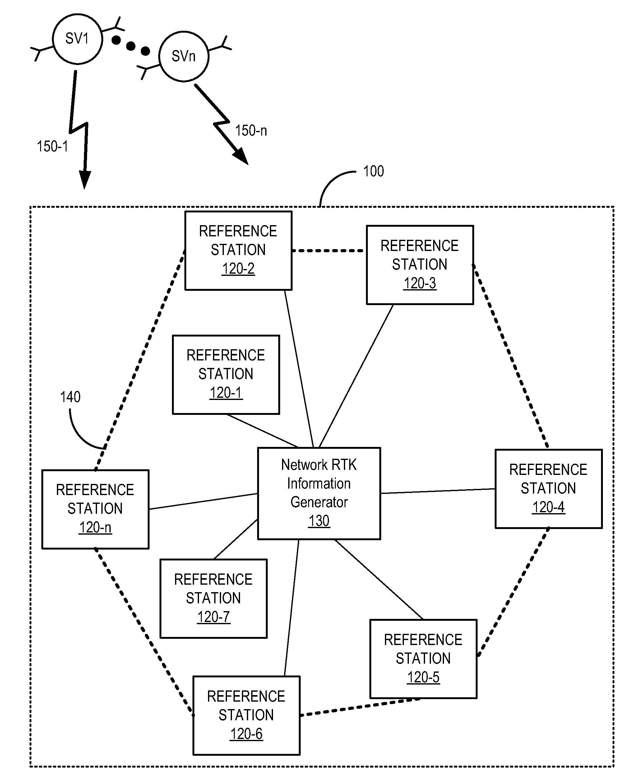
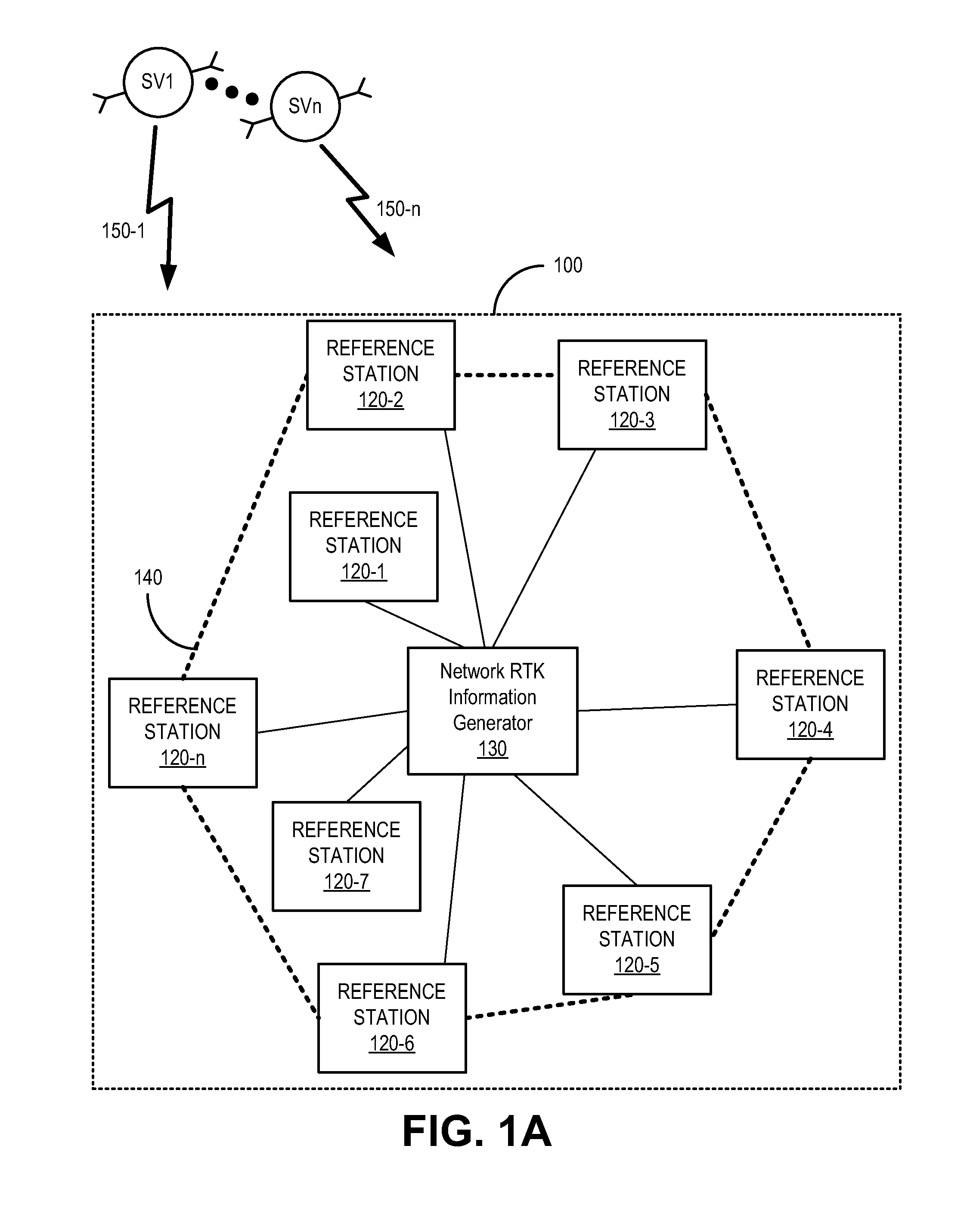
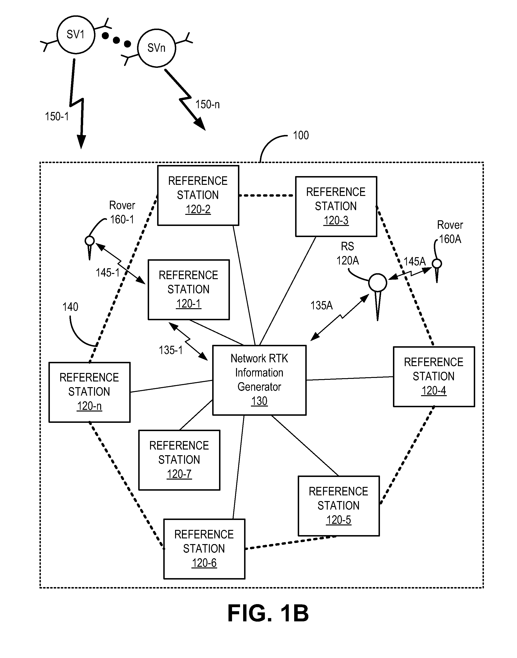
FIG. 5 is a flow diagram 500 of an example method of Global Navigation Satellite System (GNSS) reference station integrity assurance, in accordance with an embodiment. Reference will be made to elements of FIGS. 1A, 1B, 2, and 3 to facilitate the explanation of the operations of the method of flow diagram 500. In one embodiment, the method of flow diagram 500 describes a use or instructions for operation of integrity system 240 in assuring operational integrity of a reference station 120.

At operation 510, in one embodiment, at least one aspect of GNSS information local to a location of a GNSS reference station is compared with a corresponding aspect of network Real Time Kinematic (RTK) information for the location. With reference to the FIG. 1B, in one embodiment, this comprises comparator 320 comparing local GNSS information of reference station 120-1 with network RTK information for the location of reference station 120-1. This can comp...


PUM


Abstract

In a method of Global Navigation Satellite System (GNSS) reference station integrity monitoring, network Real Time Kinematic (RTK) information is accessed for a location associated with a GNSS reference station. At least one aspect of GNSS information local to the location of the GNSS reference station is compared with a corresponding aspect of the network RTK information. The results of the comparing are monitored for indication of occurrence of compromise to operational integrity of the GNSS reference station.

Description

BACKGROUNDVarious types of positioning systems for determining a position based on radio signals are known in the art. For example, satellite navigation systems allow autonomous geospatial positioning with virtually global coverage. Global navigation satellite systems (GNSS) provide GNSS receivers with the capability to determine their location based on positioning signals transmitted from the GNSS satellites in terms of longitude, latitude and altitude, to within a few meters or even centimeters.A GNSS makes use of a constellation of satellites orbiting the earth to provide signals to a receiver that estimates its position relative to the earth from those signals. Examples of such satellite systems are the NAVSTAR Global Positioning System (GPS) deployed and maintained by the United States, the GLObal NAvigation Satellite System (GLONASS) deployed by the Soviet Union and maintained by the Russian Federation, and the GALILEO system currently being deployed by the European Union (EU)...

Claims


Application Information

Patent Timeline
Patent Type & Authority Applications(United States)
IPC IPC(8): G01S19/08
CPCG01S19/04G01S19/13G01S19/20G01S19/31G01S19/42
Inventor FERGUSON, KENDALL
Owner TRIMBLE NAVIGATION LTD
Why Eureka
Try Eureka