Three Dimensional Routing

a three-dimensional routing and navigation technology, applied in the field of maps and/or navigation, can solve the problems of still existing challenges in providing navigation information

Active Publication Date: 2013-04-25
HERE GLOBAL BV
View PDF7 Cites 93 Cited by
  • Summary
  • Abstract
  • Description
  • Claims
  • Application Information

AI Technical Summary

Benefits of technology

[0004]According to one aspect, one or more systems, devices, and/or methods for three dimensional routing are disclosed. For example, one embodiment includes receiving image data selected based on a viewer perspective from a memory. The image data is correlated with a depthmap generated from an optical distancing system and correlated with route data calculated from an origin point to a destination point using a geographical database and a routing algorithm. The co

Problems solved by technology

However, challenges in providing n

Method used


Image

  • Three Dimensional Routing
  • Three Dimensional Routing
  • Three Dimensional Routing

Examples


Embodiment Construction

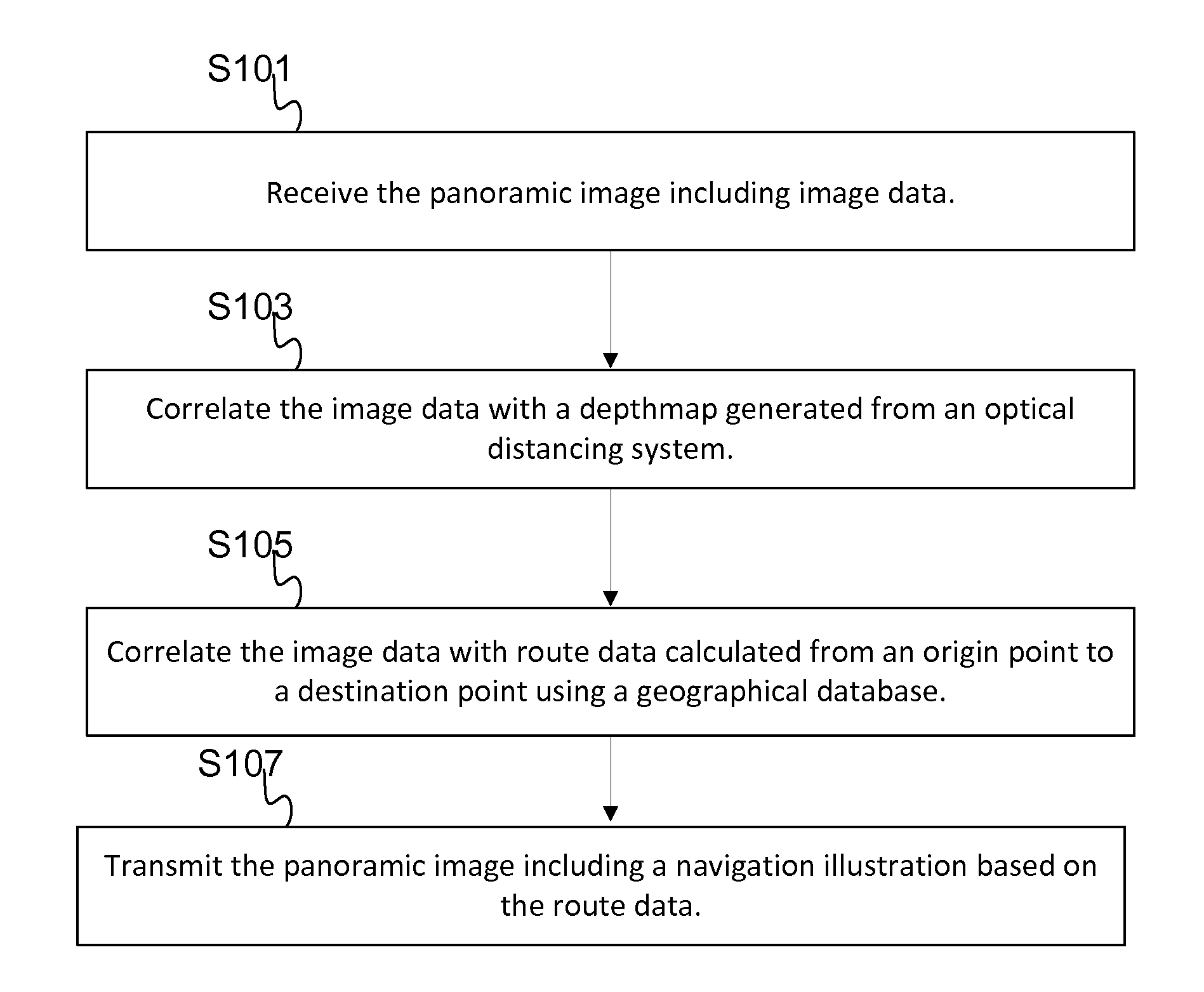
[0019]Map systems or navigation systems provide users with panoramic images, street level view images, or high-altitude images (e.g., satellite, airplane) for navigation related features or map related features for pedestrians. Navigation related features include determining an optimum route and providing directions (e.g., cues or turns) to travel along a path from an original location to a destination location. The path may be a road network, a pedestrian pathway network, or an indoor walkway network. Navigation related features may be provided by mobile devices or stationary devices.

[0020]Navigation related features may involve a computer generated route illustration in images. The route illustration, which may also be referred to as a navigation illustration, is a visual cue to the user regarding the path from the original location to the destination location that is drawn in the images. The images are photographs, collected images, or any images not entirely generated by machine...


PUM


Abstract

One or more systems, devices, and/or methods for three dimensional routing are disclosed. For example, one embodiment includes receiving image data selected based on a viewer perspective from a memory. The image data is correlated with a depthmap generated from an optical distancing system and correlated with route data calculated from an origin point to a destination point using a geographical database and a routing algorithm. The controller compares a first distance, from the viewer perspective to a point correlated with the route data, to a second distance, derived from the depth map at the point. If the comparison indicates that the first distance is closer to the viewer perspective than the second distance, the controller inserts at least one pixel of a navigation illustration into the image data. The image data including the navigation illustration is transmitted to or stored in a memory.

Description

REFERENCE TO RELATED APPLICATIONS[0001]The present patent application is related to the copending patent applications filed on the same date, Ser. No. ______, entitled “REIMAGING BASED ON DEPTHMAP INFORMATION,” Attorney Docket No. N0402US and Ser. No. ______, entitled “DEPTH CURSOR AND DEPTH MEASUREMENT IN IMAGES,” Attorney Docket No. N0406US, the entire disclosures of which are incorporated by reference herein.BACKGROUND OF THE INVENTION[0002]The present invention relates to maps and / or navigation and, more particularly, to method(s) and system(s) for illustrating routes in images, such as panoramic, street level view, or high-altitude view images, using depth information.[0003]Navigation applications may be installed in vehicles to provide images to passengers or in portable (e.g., handheld) devices such as phones, personal digital assistants, or personal navigation devices. The navigation application may provide images that aid the user in determining current position and guiding...

Claims


Application Information

Patent Timeline
IPC IPC(8): G01C21/00
CPCG01C21/3638G06T15/205G06T17/05G06F19/345G06K9/00771A61B3/0058A61B3/10A61B5/16G01C21/3602G16H50/20G06V20/52
Inventor LYNCH, JAMES D.
Owner HERE GLOBAL BV
Why Eureka
Try Eureka