Navigation Data Structure Generation And Data Transmission For Optimal Time To First Fix

a technology of data structure and navigation data, applied in the field of navigation data structure generation and data transmission for optimal time to first fix, can solve the problems of ineffective processing of navigation signals for reducing line of sight (lost) ttff, delay in collecting navigation data translation, and high deployment costs

Active Publication Date: 2013-06-06
ACCORD SOFTWARE & SYST PVT
View PDF8 Cites 25 Cited by
  • Summary
  • Abstract
  • Description
  • Claims
  • Application Information

AI Technical Summary

Problems solved by technology

However, these methods are generally expensive in terms of deployment costs, complexity of the satellite navigation receiver, etc.
Furthermore, conventional methods for reducing TTFF have often been ineffective in processing navigation signals for reduction of line of sight (LOS) TTFF.
The delay in collecting the navigation data translates to multiple delays, for example, delays in computing satellite visibility, delays in estimation of ionosphere delay estimation coefficients, delays in cross-correlation detection based on the range estimated using the almanac data and an integrity check specified by the federal aviation administration (FAA) for beta-3 civil aviation receivers, etc.
Conventional satellite navigation receivers take a relatively long time, for example, about 12.5 minutes to collect the almanac data for a single frequency user.
This constrains the time taken for the collection of the ephemeris data and delays the TTFF.
This delays the ionosphere error computation and thus delays accurate positioning in a satellite navigation receiver.
Moreover, parameters such as UTC parameters compound the delay and bandwidth overhead since the UTC parameters need not be transmitted very frequently for computation of the user's position.
However, Galileo uses a navigation data structure with a larger number of sub-frames and imposes constraints in terms of memory requirements and an increased amount of time required for transmitting the complete navigation data structure.
This increases the time overhead in almanac transmission and increases the almanac data collection time at the satellite frequency receiver, thereby delaying ionosphere estimation at the satellite navigation receiver.

Method used


Image

  • Navigation Data Structure Generation And Data Transmission For Optimal Time To First Fix
  • Navigation Data Structure Generation And Data Transmission For Optimal Time To First Fix
  • Navigation Data Structure Generation And Data Transmission For Optimal Time To First Fix

Examples


Embodiment Construction

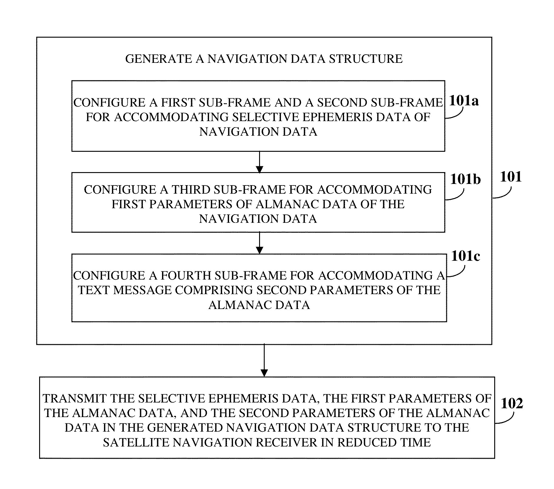
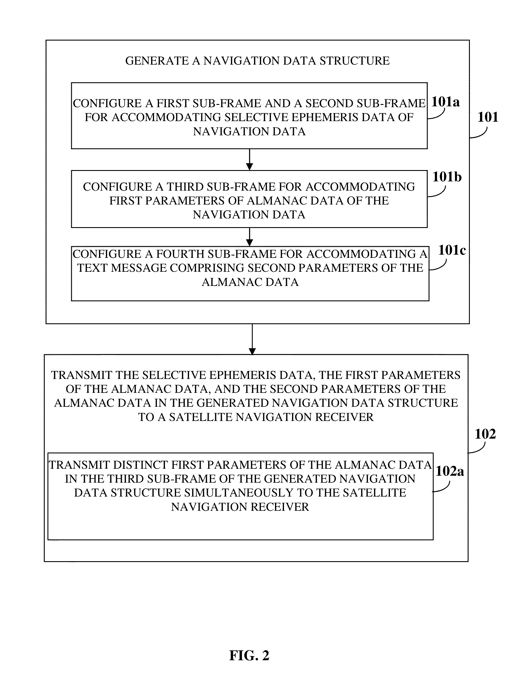
[0048]FIG. 1 illustrates a method for transmitting navigation data to a satellite navigation receiver for reducing time to first fix (TTFF) in the satellite navigation receiver. The method disclosed herein enables transmission of the navigation data to a single frequency satellite navigation receiver for reducing time to first fix in the single frequency satellite navigation receiver. The method disclosed herein provides a signal generation system for generating 101a navigation data structure as exemplarily illustrated in FIG. 6. The navigation data structure comprises a first sub-frame, a second sub-frame, a third sub-frame, and a fourth sub-frame. The signal generation system configures 101a the first sub-frame and the second sub-frame for accommodating selective ephemeris data of the navigation data. As used herein, the term “selective ephemeris data” refers to essential ephemeris parameters that define orbital information of a satellite. The selective ephemeris data comprises, f...


PUM


Abstract

A method and system for transmitting navigation data to a satellite navigation receiver for reducing time to first fix is provided. A signal generation system generates a navigation data structure comprising a first sub-frame and a second sub-frame for accommodating selective ephemeris data, a third sub-frame for accommodating first parameters of almanac data, and a fourth sub-frame for accommodating a text message comprising second parameters of almanac data, and transmits the selective ephemeris data and the first and second parameters of almanac data to the satellite navigation receiver. The configuration of the navigation data structure enables the satellite navigation receiver to collect the navigation data in reduced time. Each satellite of a constellation simultaneously transmits distinct first parameters of the almanac data in the third sub-frame of the navigation data structure to the satellite navigation receiver, thereby allowing the satellite navigation receiver to receive collective almanac data in reduced time.

Description

CROSS REFERENCE TO RELATED APPLICATIONS[0001]This application claims the benefit of non-provisional patent application number 4231 / CHE / 2011 titled “Navigation Data Structure Generation And Data Transmission For Optimal Time To First Fix”, filed on Dec. 5, 2011 in the Indian Patent Office.[0002]The specification of the above referenced patent application is incorporated herein by reference in its entirety.BACKGROUND[0003]The advent of autonomous regional satellite based navigation systems has enabled some countries to cover their territorial footprint and the footprint of their surrounding areas. The purpose of a regional satellite based navigation system, such as a global navigation satellite system (GNSS), is to cater to the needs of specific users, for example, the military, for military applications using a precision service (PS) and civilian users, for example, for civilian applications using a standard positioning service (SPS). For example, India is planning to deploy an auton...

Claims


Application Information

Patent Timeline
Patent Type & Authority Applications(United States)
IPC IPC(8): G01S19/07
CPCG01S19/02G01S19/01G01S19/235
Inventor RAO, VYASARAJ GURU
Owner ACCORD SOFTWARE & SYST PVT
Why Eureka
Try Eureka