Method and System for Identifying Management Zones for Variable-Rate Crop Inputs

a management zone and variable-rate technology, applied in soil-working methods, instruments, data processing applications, etc., can solve the problems of low yield in all years, achieve high plant biomass and yield, improve yield, and reduce the effect of plant biomass and yield

Inactive Publication Date: 2013-09-05
PHANTOM AG LTD
View PDF5 Cites 29 Cited by
  • Summary
  • Abstract
  • Description
  • Claims
  • Application Information

AI Technical Summary

Benefits of technology

[0011]According to the present invention, soil-based data is used to generate soil maps and elevation-based data is used to generate water maps and topography maps. These soil, water and topography maps are then combined in various ways to generate a plurality of zone maps, which merge different attributes from the soil, water and topography maps in different proportions. The plurality of zone maps go through a “truthing” process which allows comparison of the plurality of zone maps against actual field observation data to determine which of the zone maps most accurately reflects those field characteristics most likely to have the primary impact on crop input recommendations. In this way, and unlike prior art methods, observed field data can be used to select which of the zone maps will be more likely to enable an optimal crop input prescription, whereas with prior art methods a single map is generated based on set criteria that may or may not fully reflect overriding field characteristics. Each zone map illustrates field characteristics by using a particular zone definition system based on soil and elevation based criteria, again unlike the prior art methods. Remote sensing of plant density is not used to build these zone maps, as fields with a high degree of soil, water, and topography variability will respond differently under various environmental conditions. For example, a water collection area may have a low plant biomass and yield in a wet year due to flooding but may have a high plant biomass and yield in a dry year as the extra moisture provided improved yields. Conversely, if a water collection area has a high salt content it will have low yields in all years. Maps that can define multiple features of areas within the field and define what the primary source of variability is likely to be can thus provide a clearer understanding of how these areas are most likely to respond to crop inputs.

Problems solved by technology

Conversely, if a water collection area has a high salt content it will have low yields in all years.

Method used


Image

  • Method and System for Identifying Management Zones for Variable-Rate Crop Inputs
  • Method and System for Identifying Management Zones for Variable-Rate Crop Inputs
  • Method and System for Identifying Management Zones for Variable-Rate Crop Inputs

Examples


Embodiment Construction

)

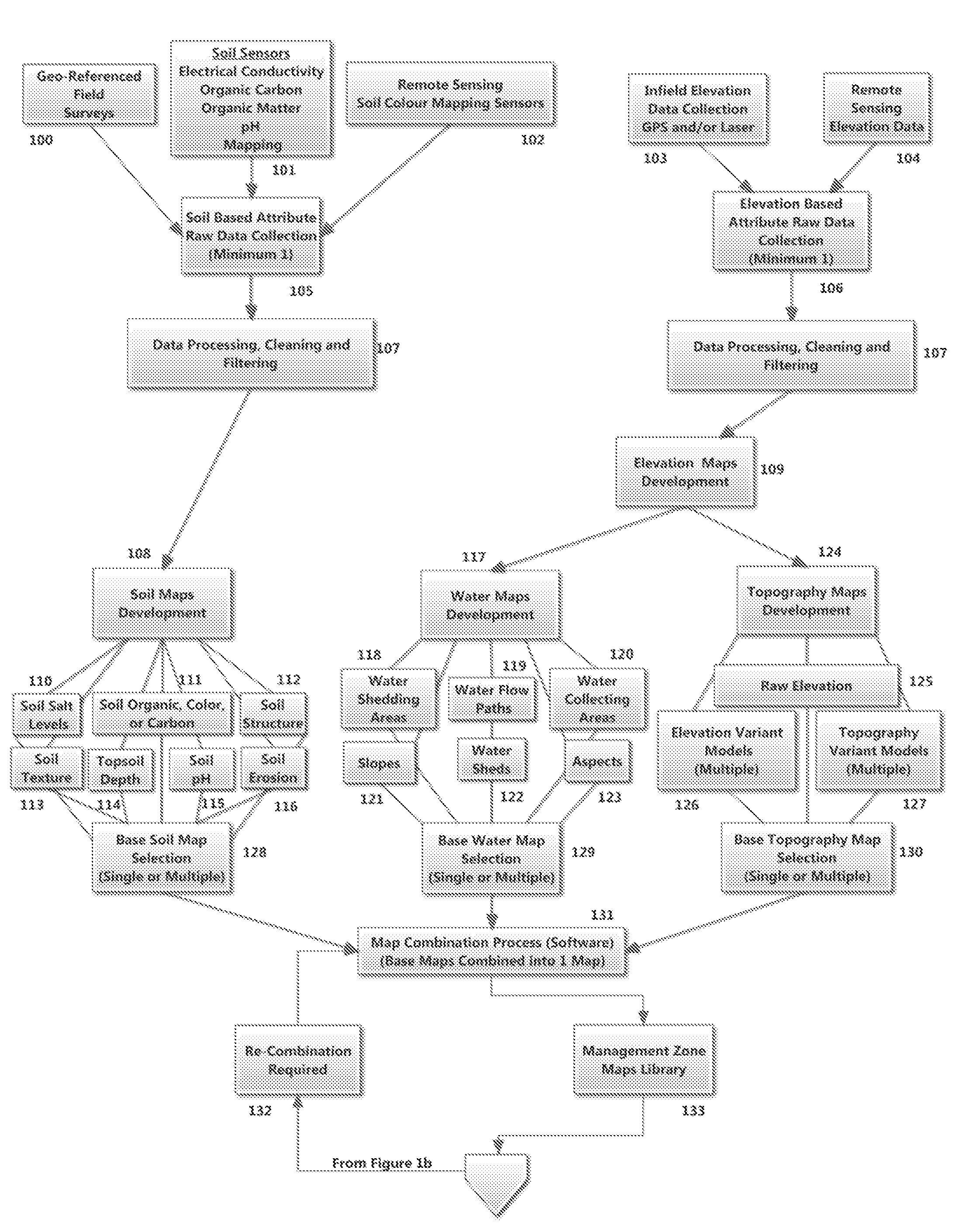
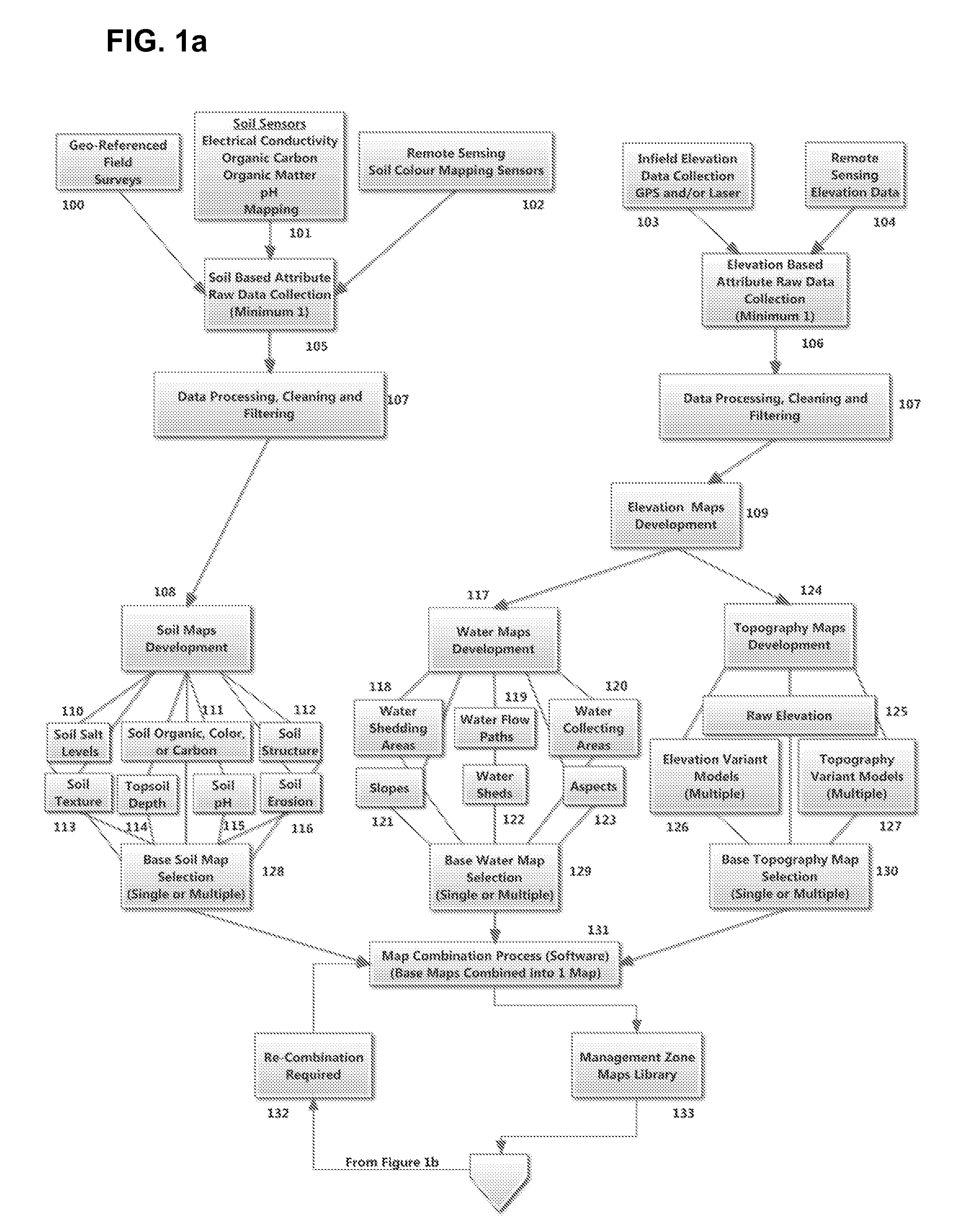
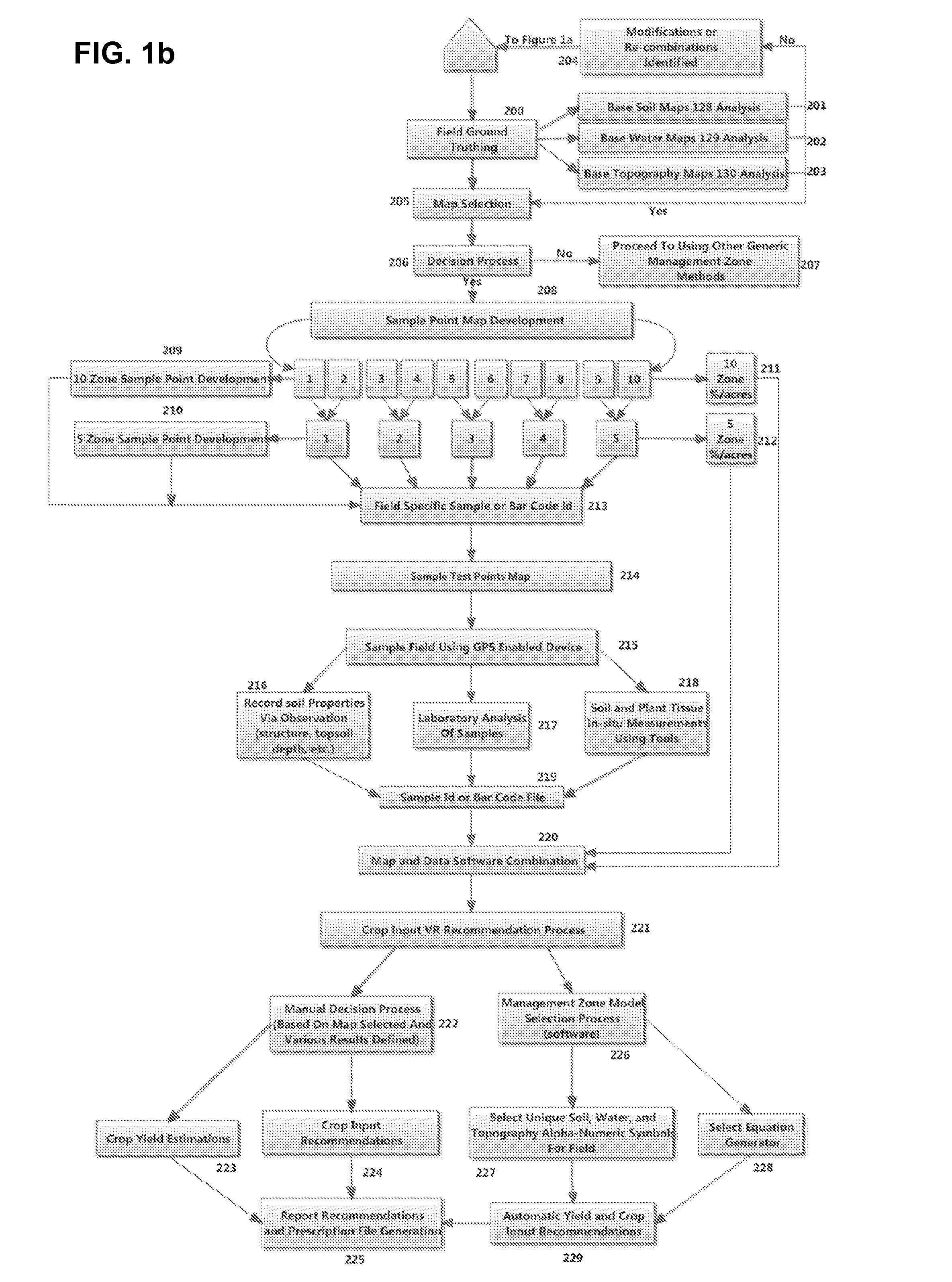
[0019]Soil, water and topography attribute data collection is employed to identify management zones for variable-rate crop inputs. Crop inputs include but are not limited to fertilizer, seed, pesticide, and soil remediation products. The method according to the present invention includes the collection of soil and elevation based field data and the generation of base maps reflecting such data. The base maps are combined in several different ways to generate a plurality of zone maps which each highlight different aspects of the base map information and illustrate those aspects. Based on actual field observation data, a specific zone map is selected that best represents the predominant field aspects that are most likely to have the greatest impact on crop inputs and field productivity.

[0020]An exemplary method and system according to the present invention is set out below with reference to the accompanying drawings.

Method

[0021]Data Collection. The first step in the exemplary method i...


PUM


Abstract

A method and system for identifying management zones for variable-rate crop inputs, wherein the zones are developed using soil, water and topography base maps. The base maps are combined into various different zone maps, and a final zone map is selected on the basis of observed field characteristics.

Description

CROSS-REFERENCE TO RELATED APPLICATIONS[0001]This application claims priority from Canadian Patent Application 2770216 filed on Mar. 2, 2012 which is hereby incorporated by reference in its entirety.BACKGROUND OF THE INVENTION[0002]1. Field of the Invention[0003]The present invention relates to methods and systems for managing crop inputs such as fertilizer in large agricultural fields, and more specifically to the analysis of field characteristics to help determine prescriptions for crop input levels.[0004]2. Related Art[0005]It is well known that productivity demands on agricultural land have been increasing and therefore requiring new and enhanced methods for extracting greater yield from existing fields. Increased global environmental concerns have also prompted agricultural practices to recognize that air, water, and soil stewardship are as important as safe and healthy food production. This has resulted in the development and deployment of various enhancement technologies, suc...

Claims


Application Information

Patent Timeline
Patent Type & Authority Applications(United States)
IPC IPC(8): G06Q50/02
CPCG06Q50/02A01B79/005G06Q10/0631
Inventor WILLNESS, CORWYN
Owner PHANTOM AG LTD
Why Eureka
Try Eureka