Position in Urban Canyons

a technology of urban canyons and positions, applied in the field of positioning in urban canyons, can solve problems such as delays or artifacts in radio communication signals, buildings may block radio waves, and other satellite-based positioning systems are susceptible to delays in radio communication signals

Active Publication Date: 2014-08-14
HERE GLOBAL BV
View PDF7 Cites 34 Cited by
  • Summary
  • Abstract
  • Description
  • Claims
  • Application Information

AI Technical Summary

Benefits of technology

[0005]In one embodiment, the position of a mobile device is determined based, at least on part, of the relative locations of two or more nearby points. Distance data, received from a range finding sensor, corresponds to distances to the two or more nearby points from the mobile device. A predetermined model that includes previously recorded locations for objects is accessed to receive location data for two or more nearby points. A position of the mobile device is calculated based on the location data and the distance data. The nearby points may be building edges or building corners. The calculation may involve a series of equations. The series of equations may include satellite-based positioning equations in addition to equations based on the predetermined model.

Problems solved by technology

Radio waves may be blocked by buildings.
Thus, delays or artifacts may be introduced in radio communication signals by the urban canyon.
The global positioning system (GPS) and other satellite-based positioning systems are susceptible to delays in radio communication signals.
Satellite-based positioning systems become unreliable in urban canyons because communication signals may be blocked or delayed.
GPS and other satellite-based positioning systems suffer accuracy problems from either lack of positioning capability due to reduced number of visible satellite or the multipath reflections due to urban canyons or other areas where the sky is partially occluded.
The satellite-based positioning unit may experience inaccuracies because of the urban canyon.
Multipath may cause phase shifting, constructive interference or destructive interference, any of which degrade the radio signal strength also.
Satellite-based positioning systems are particularly susceptible to multipath.
Thus, the satellite-based positioning unit calculates an inaccurate position.
There is not a range of possible locations for the building corner.
Additionally, the illustrations are merely representational and may not be drawn to scale.

Method used


Image

  • Position in Urban Canyons
  • Position in Urban Canyons
  • Position in Urban Canyons

Examples


Embodiment Construction

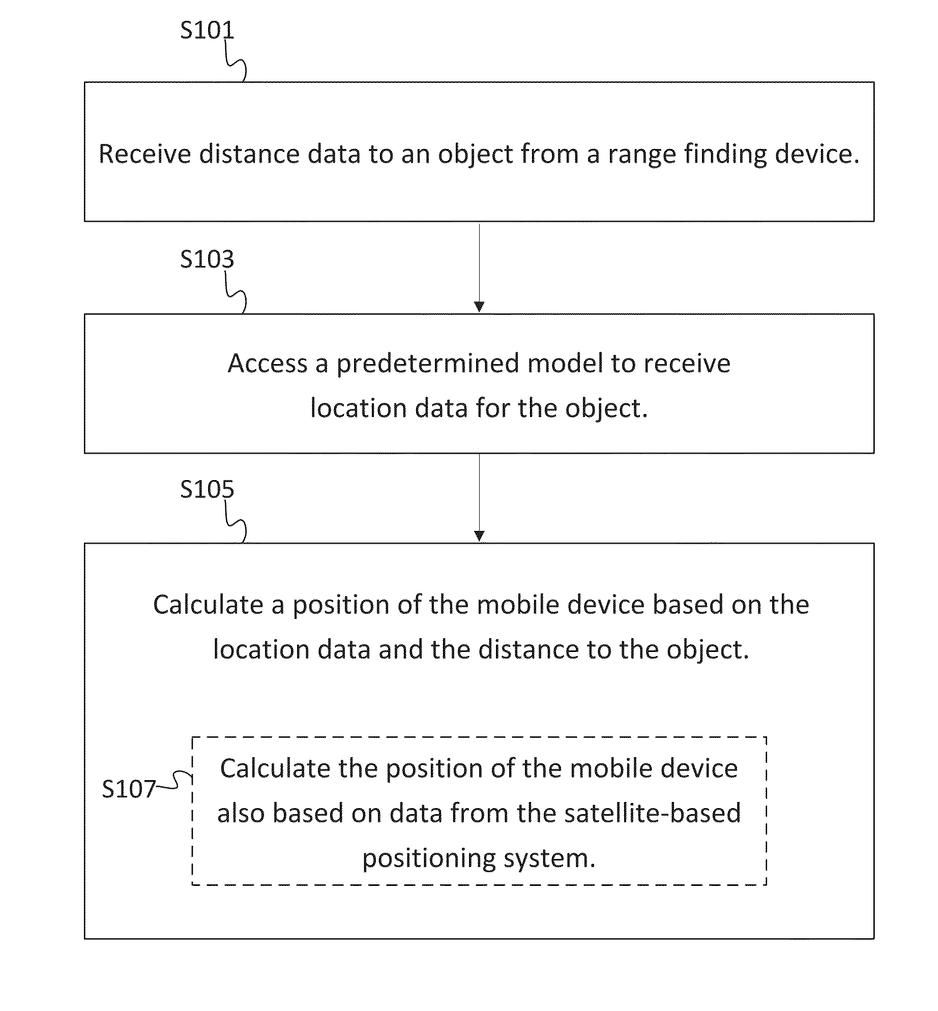
[0018]GPS and other satellite-based positioning systems suffer accuracy problems from either lack of positioning capability due to reduced number of visible satellite or the multipath reflections due to urban canyons or other areas where the sky is partially occluded. The following embodiments use distances measured to building corners or edges using a range finding device (e.g., a light detection and ranging (LIDAR) sensor or another optical sensor) and stored coordinates of the building corners to calculate user position. The technique may be employed at all times or when GPS readings are inaccurate or not available. The coordinates of the building corners are obtained from a building model or a map database. The calculated position may be the position of a mobile device and / or vehicle. Therefore by solving positioning in urban canyons, a seamless positioning can be achieved everywhere in outdoor environment.

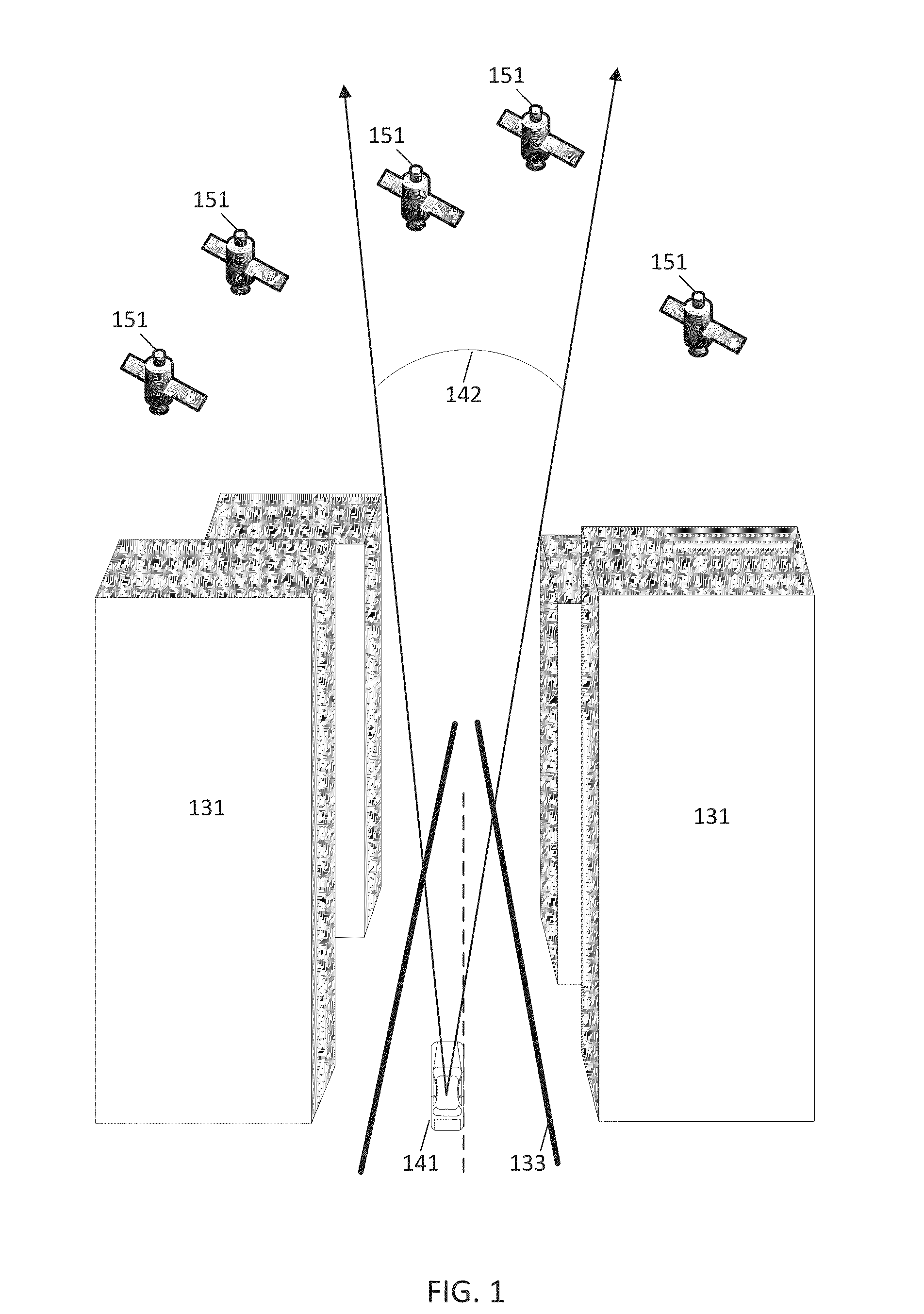
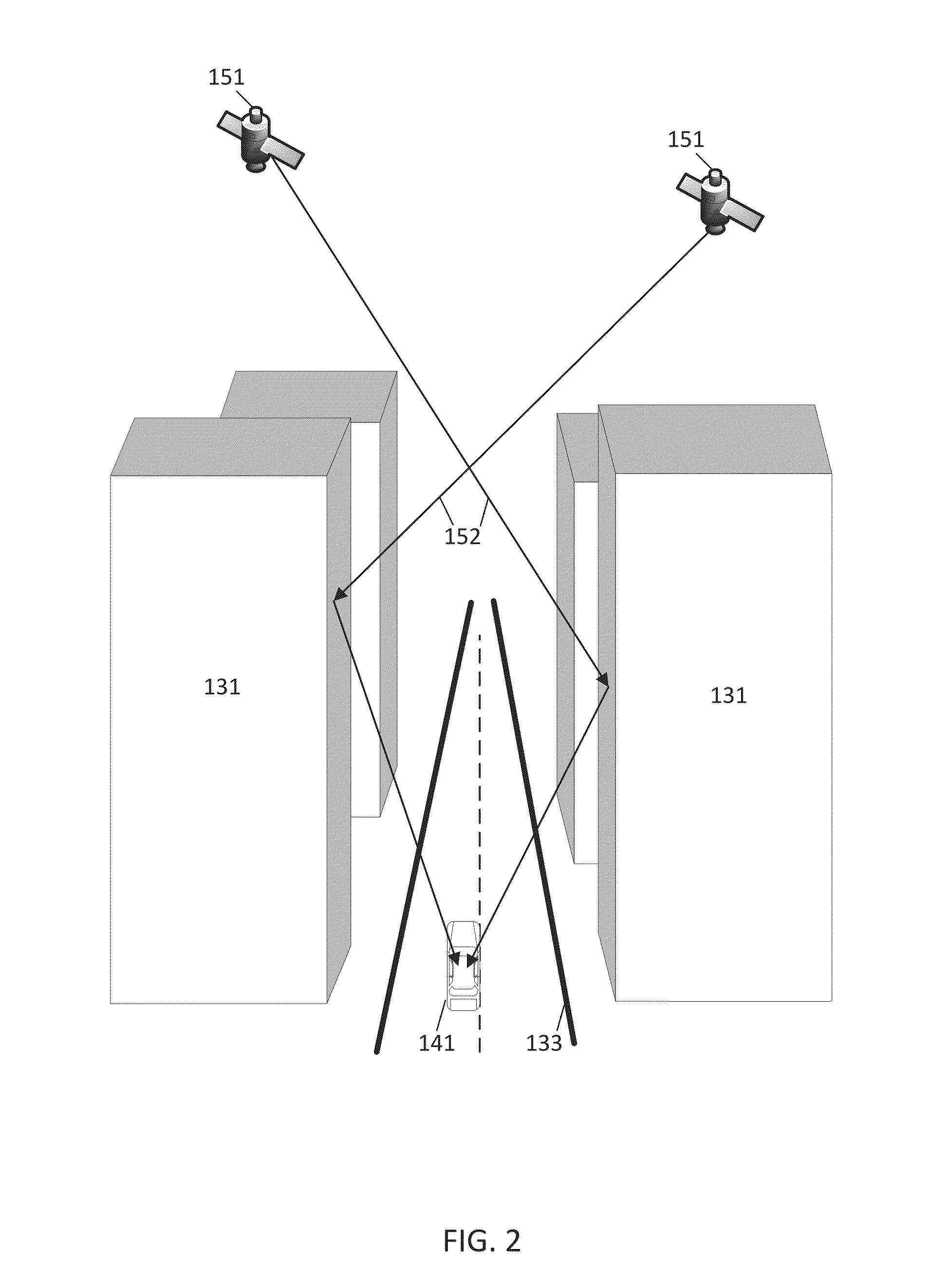
[0019]FIG. 1 illustrates an urban canyon between buildings 131. A vehicle...


PUM


Abstract

In one embodiment, the position of a mobile device is determined based, at least on part, of the relative locations of two or more nearby points. Distance data, received from a range finding sensor, corresponds to distances to the two or more nearby points from the mobile device. A predetermined model that includes previously recorded locations for objects is accessed to receive location data for two or more nearby points. A position of the mobile device is calculated based on the location data and the distance data. The nearby points may be building edges or building corners. The calculation may involve a series of equations. The series of equations may include satellite-based positioning equations in addition to equations based on the predetermined model.

Description

FIELD[0001]The following disclosure relates to determining a user position in urban canyons or other occluded areas.BACKGROUND[0002]A canyon is a deep ravine or gorge between land masses or cliffs. A canyon is often carved out by a river that flows in the bottom of the canyon. A similar geographic feature occurs in urban areas as skyscrapers or other buildings imitate cliffs with the streets below running like rivers. These man made topographies are referred to as urban canyons. Urban canyons have been studied for the effects on temperature, wind, and air quality.[0003]In addition, urban canyons may influence radio communication. The propagation of radio waves may be affected by urban canyons. Radio waves may be blocked by buildings. Radio waves may be reflected off buildings and diffracted around buildings, following different paths to the same destination. Thus, delays or artifacts may be introduced in radio communication signals by the urban canyon.[0004]The global positioning sy...

Claims


Application Information

Patent Timeline
Patent Type & Authority Applications(United States)
IPC IPC(8): G01S19/45G01S17/86
CPCG01S19/45G01S17/46G01S19/22G01S5/16G01S17/86G01S19/485
Inventor PHUYAL, BISHNUBACH, JEFFREY R.ALWAR, NARAYANAN
Owner HERE GLOBAL BV
Why Eureka
Try Eureka