Generating Cinematic Flyby Sequences Following Paths and GPS Tracks

a technology of cinematic flyby and gps track, applied in the direction of 3d-image rendering, instruments, computing, etc., can solve the problem that conventional gis systems are often limited in their ability to effectively utilize gps data

Active Publication Date: 2015-06-18
GOOGLE LLC
View PDF9 Cites 22 Cited by
  • Summary
  • Abstract
  • Description
  • Claims
  • Application Information

AI Technical Summary

Benefits of technology

[0007]A capability for generating cinematic fly-by sequences following paths and GPS tracks is provided. In an embodiment, a computer-implemented method provides an animated visualization of geo-located objects in a geographic information system. The method includes: (1) determining a first position of a first moving object to be visualized at a first time in an interactive three-dimensional environment of the geographic information system based on geographic positioning data associated with the first moving object over a period of time; (2) positioning a graphical representation of the first moving object at the first time in the interactive three-dimensional environment according to the determined first position; (3) determining a second position of the first moving object to be visualized at a second time in the interactive three-dimensional environment based on the geographic positioning data associated with the first moving object; (4) defining a first path of a virtual camera in the interactive three-dimensional environment based on the determined first and second positions of the first moving obj...

Problems solved by technology

However, conventional GIS systems are often limited in their ability to effectively utiliz...

Method used


Image

  • Generating Cinematic Flyby Sequences Following Paths and GPS Tracks
  • Generating Cinematic Flyby Sequences Following Paths and GPS Tracks
  • Generating Cinematic Flyby Sequences Following Paths and GPS Tracks

Examples


example gui

of a GIS Browser

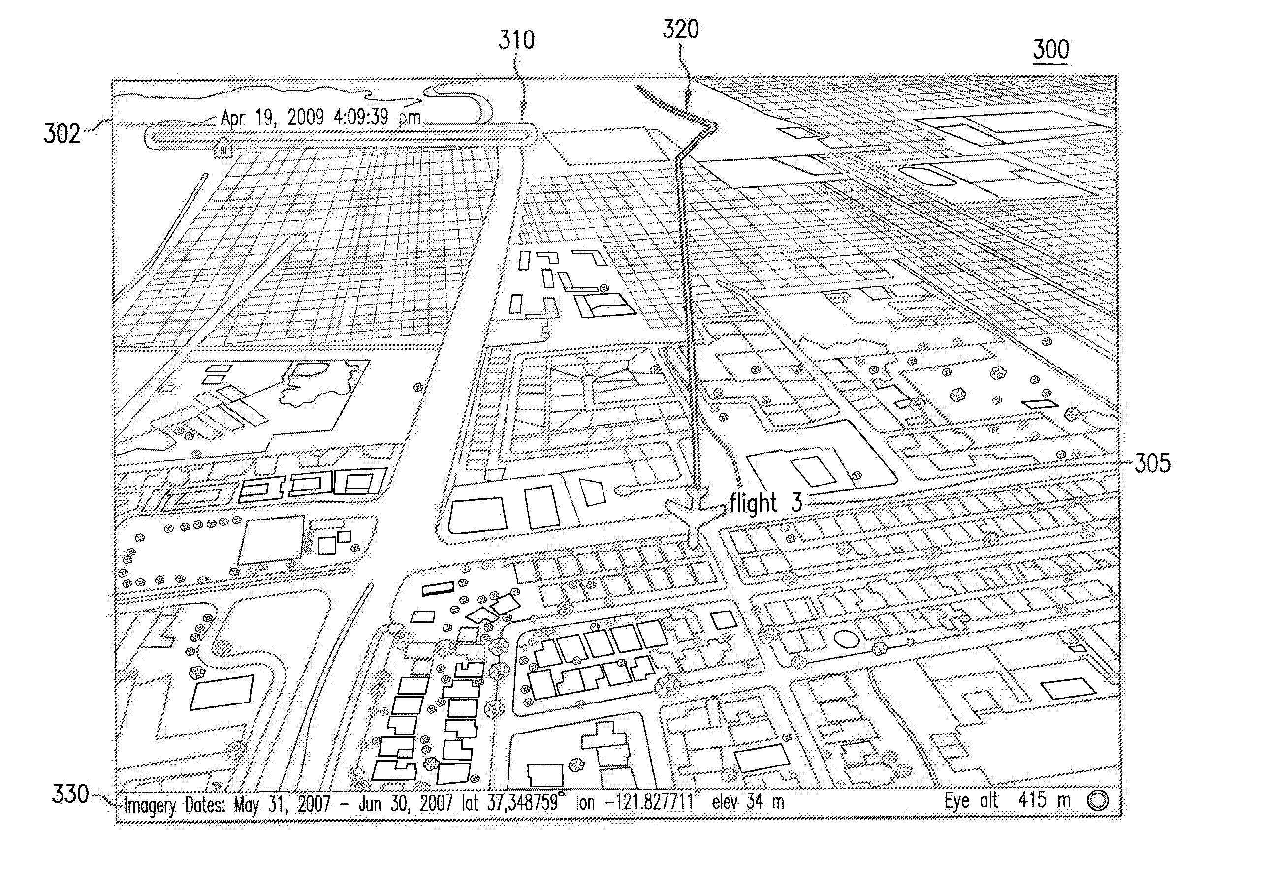
[0033]FIG. 1 illustrates an exemplary graphical user interface (GUI) of an interactive geospatial browser 100 in a GIS system, according to an embodiment. In an embodiment, browser 100 is a spatial and temporal browser that enables a user to view various types of geographic information, corresponding to a particular geographic area at a specific time. As such, browser 100 provides the user with a notion of both “where” the user is viewing and “when” the user is viewing. In an example, browser 100 may enable the user to view imagery corresponding to one or more geographic regions or areas at various points in time as selected by the user (e.g., via a user interface control provided in browser 100). For example, such imagery may be presented to the user via a display that is coupled to a computing device implementing browser 100. As illustrated in the example GUI of FIG. 1, browser 100 includes a display window 102, a control portion 108 including data filters 110, and...

example encoding

Language

[0069]FIG. 5 is a portion of code 500 that may be used to provide animated visualization of geo-located objects, according to an example embodiment. In an embodiment, code 500 may be based on the Keyhole Markup Language (KML) for encoding and visualizing geographic information and representations of one or more moving objects within a geographic environment (e.g., geographic environments 302 and 402 of FIGS. 3 and 4, respectively, as described above). As would be apparent to a person skilled in the relevant art given this description, KML in general may include various notations based upon XML (extensible markup language) notation for expressing geographic annotations and visualizations, as described above. Further, such visualizations may include two-dimensional and three-dimensional maps or environments encoded using KML notation. It should be understood that KML is an example coding language by which at least a portion of the features herein may be implemented, while othe...


PUM


Abstract

A visualization system and method allow moving objects to be visualized in a GIS system as an interactive animation by moving an icon or 3D graphical model in an interactive virtual environment of the GIS. A line may also be drawn behind the icon/3D model representing the path traveled during a window of time. Additionally, the evolution of time-dependent data associated with the moving object may be encoded and visualized in the GIS.

Description

CROSS REFERENCE TO RELATED APPLICATIONS[0001]This patent application claims the benefit of U.S. Provisional Patent Application No. 61 / 497,004, (Attorney Docket No. 2525.4660000), filed Jun. 14, 2011, entitled “Generating Cinematic Flyby Sequences Following Paths and GPS Tracks,” which is incorporated herein by reference in its entirety.BACKGROUND[0002]1. Field[0003]Embodiments of the present invention relate generally to navigating in a geographic information system (GIS).[0004]2. Background[0005]A geographic information system (GIS) is a system for archiving, retrieving, displaying or manipulating data indexed according to the data elements' respective geographic coordinates. The data elements may be a variety of data types such as, for example, satellite imagery, maps, models of buildings and terrain, and other geographic features. Further, data elements may include representations of real-world objects at various geographic locations. For example, geographic coordinates of the ob...

Claims


Application Information

Patent Timeline
IPC IPC(8): G06T15/20G06K9/00G06T13/20
CPCG06T15/20G06K9/00476G06T13/20G06T17/05G06T19/003G06V30/422
Inventor BARCAY, DANIEL
Owner GOOGLE LLC
Why Eureka
Try Eureka