Three-dimensional geospatial visualization

a geospatial visualization and three-dimensional technology, applied in the field of three-dimensional visualization of geospatial data, can solve the problems of limiting the viewer's freedom to explore a given setting, imagery is not unified, and movement is restricted

Active Publication Date: 2016-07-07
GEOPOGO INC
View PDF6 Cites 40 Cited by
  • Summary
  • Abstract
  • Description
  • Claims
  • Application Information

AI Technical Summary

Benefits of technology

[0011]Further, in one embodiment, the movement of the persona in the point cloud data can be set to various speeds representing at least one of a pedestrian speed, bicycle speed, automobile speed, airplane speed, or air-balloon speed. In one embodiment, real-time events are displayed to the user using video cameras (e.g., IP cameras, web cameras, etc.) present at the geographical location. Additionally, in one embodiment, mobile vehicles can be present that can be used to access certain features (e.g., access to website portals of merchants or vendors who do not have a brick and mortar location, providing a similar experience to street vendors in the real world). In another embodiment, exterior settings can be rendered “transparent”, revealing interior spaces within. In one embodiment, interior settings can include options to pass freely to other non-adjacent setting by means of designated secret passages / portals.
[0012]In yet another embodiment, the geospatial 3D models can be customized to the preferences of different users of the system, thus accommodating the needs of pedestrians, bicyclists, automobile users, etc., and presenting such users a virtual world of the realistic representation of a physical location.

Problems solved by technology

However, such imagery is not unified and movement is restricted to the vantage point of the source of the two-dimensional images.
This limits the viewer's freedom to move through and explore a given setting.
Furthermore, conventional methods are usually automobile oriented with a bias towards vehicular way-finding rather than pedestrian experience.

Method used


Image

  • Three-dimensional geospatial visualization
  • Three-dimensional geospatial visualization
  • Three-dimensional geospatial visualization

Examples


Embodiment Construction

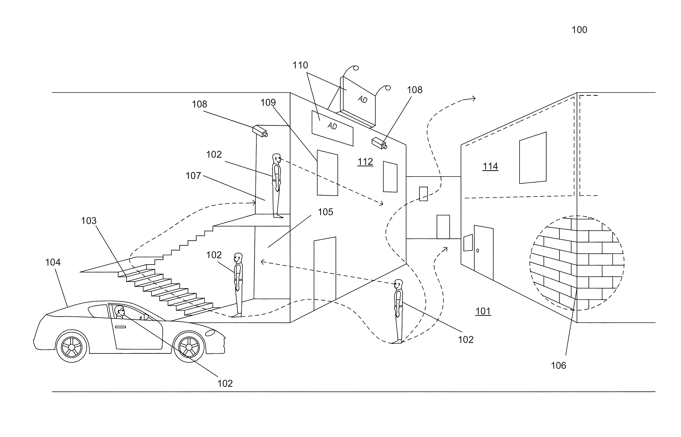
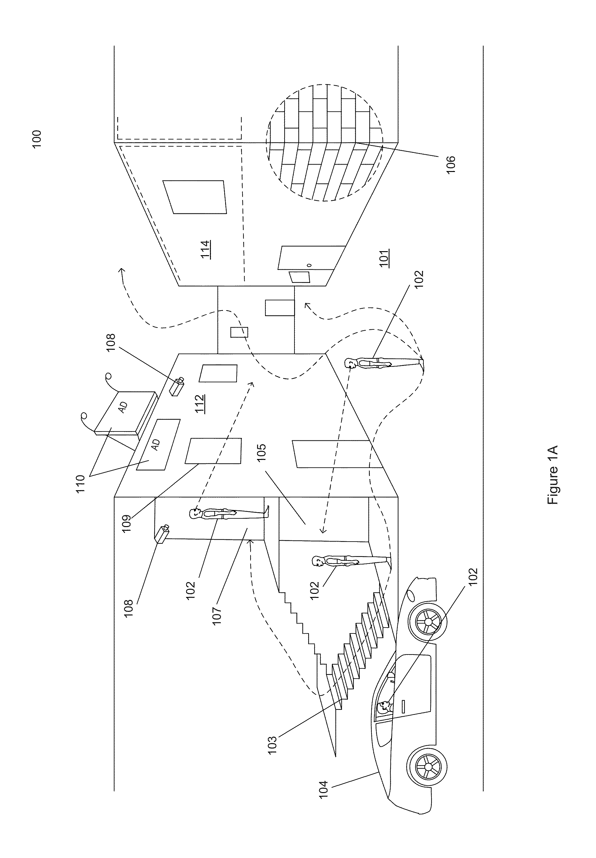
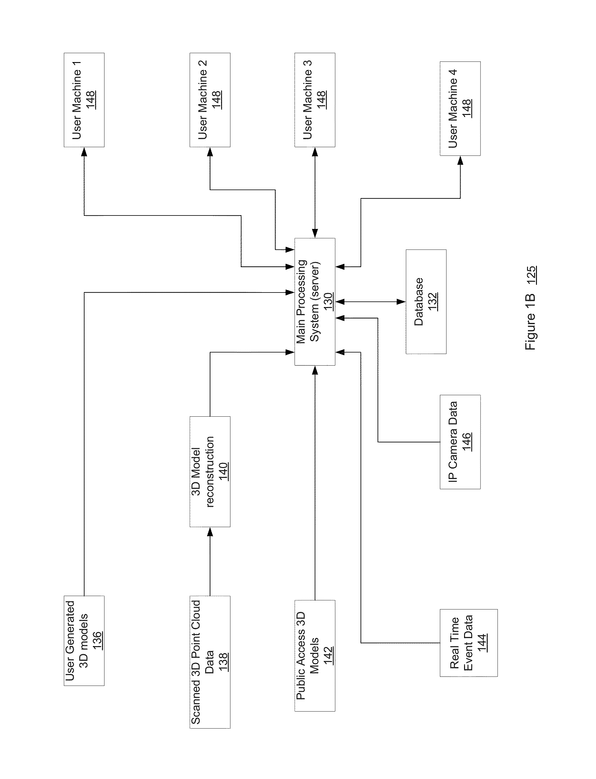
[0031]Various embodiments and aspects of the inventions will be described with reference to details discussed below, and the accompanying drawings will illustrate the various embodiments. The following description and drawings are illustrative of the invention and are not to be construed as limiting the invention. Numerous specific details are described to provide a thorough understanding of various embodiments of the present invention. However, in certain instances, well-known or conventional details are not described in order to provide a concise discussion of embodiments of the present inventions.

[0032]The processes depicted in the figures that follow are performed by processing logic that comprises hardware (e.g., circuitry, dedicated logic, etc.), software, or a combination of both. Although the processes are described below in terms of some sequential operations, it should be appreciated that some of the operations described can be performed in a different order. Moreover, som...


PUM


Abstract

Using various embodiments, methods, and systems for implementing three-dimensional geospatial visualization techniques are disclosed. In one embodiment, a unified indoor/outdoor three-dimensional visualization of interior and exterior settings can be provided using a publically accessible geospatial website. The geospatial website can provide global positioning system coordinated point cloud data of actual exterior settings along with fantasized or actual interior settings to a client machine along with information of events occurring at the location in real time.

Description

CROSS REFERENCE TO RELATED APPLICATIONS[0001]The present application claims priority from U.S. Provisional Patent Application No. 62 / 100,840 filed on Jan. 7, 2015. under 35 U.S.C. 119(e). The contents of the above mentioned provisional patent application is incorporated herein by reference for all purposes to the extent that such subject matter is not inconsistent herewith.FIELD OF THE INVENTION[0002]Embodiments of the present invention generally relate to the field of three-dimensional visualization of geospatial data. More particularly, embodiments of the invention relate to a mechanism to present a unified indoor / outdoor representation of structures, buildings, and objects using geospatial data.BACKGROUND OF THE INVENTION[0003]Conventional methods usually simulate three-dimensional visualization based imagery using two-dimensional technology. Such conventional methods include joining multiple individual images, e.g., panoramic bubble images, satellite images, photogrammetry, etc....

Claims


Application Information

Patent Timeline
Patent Type & Authority Applications(United States)
IPC IPC(8): G06T17/05G06T19/00
CPCG06T17/05G06T2219/024G06T2210/61G06T19/003G06T15/00G06T19/00G06T2210/56
Inventor ALPERT, DAVIDSORRENTO, GABRIELE
Owner GEOPOGO INC
Why Eureka
Try Eureka