
Adaptative antenna assembly for improving precision of a GNSS receiver in a perturbated environment

a technology of gnss receiver and adaptable antenna, which is applied in the field of adaptative antenna assembly for gnss receiver, can solve the problems of increasing error, difficult to mitigate in a consistent and efficient manner, and poor precision of pvt calculation

Active Publication Date: 2017-11-30
CENT NAT DETUD SPATIALES C N E S
View PDF1 Cites 5 Cited by
  • Summary
  • Abstract
  • Description
  • Claims
  • Application Information

AI Technical Summary

Benefits of technology

This patent describes a technology that improves the accuracy and performance of antennas for various applications, including communication and navigation. It achieves this by using a cost-effective and versatile approach that can work in a variety of environments without needing additional data. Additionally, it provides protection against spoofing and jamming, which are common threats in these environments.

Problems solved by technology

It is more difficult to mitigate in a consistent and efficient manner some errors which depend on the position of the receiver, notably when this position is environed by a number of objects which reflect the navigation RF signals and / or mask a number of the satellites which should be in line of sight (LOS) at a moment in time.
In such conditions, the precision of the calculation of the PVT may be quite poor, all other causes of errors being equal, both at the time of acquiring a GNSS signal and at the time of tracking said signal.
In urban canyons (i.e. streets in between skyscrapers), multipath will not only increase the error in the determination of the pseudo-range of a satellite (User Equivalent Range Error or UERE), but also the (Geometric) Dilution Of Precision, (GDOP or DOP), because the field of view of the antenna will be narrower thus limiting the increase in precision due to the use of additional satellites.
The correlation functions will be corrupted by multipath and the satellite may be not correctly acquired or may be lost.
Even if signal tracking is still achievable, signal impairments will affect the correlation function's shape, thus degrading the pseudo-range estimation, and the UERE.
All these solutions are complex and costly to implement either at the hardware level or at the software level.
In any case, they cannot be currently implemented in a standard consumer receiver of the type used in a smart phone or a car navigation system.
Solutions of this kind are quite complex to implement because they require an INS platform and external data and necessitate significant processing power.

Method used


Image

  • Adaptative antenna assembly for improving precision of a GNSS receiver in a perturbated environment
  • Adaptative antenna assembly for improving precision of a GNSS receiver in a perturbated environment
  • Adaptative antenna assembly for improving precision of a GNSS receiver in a perturbated environment

Examples


Embodiment Construction

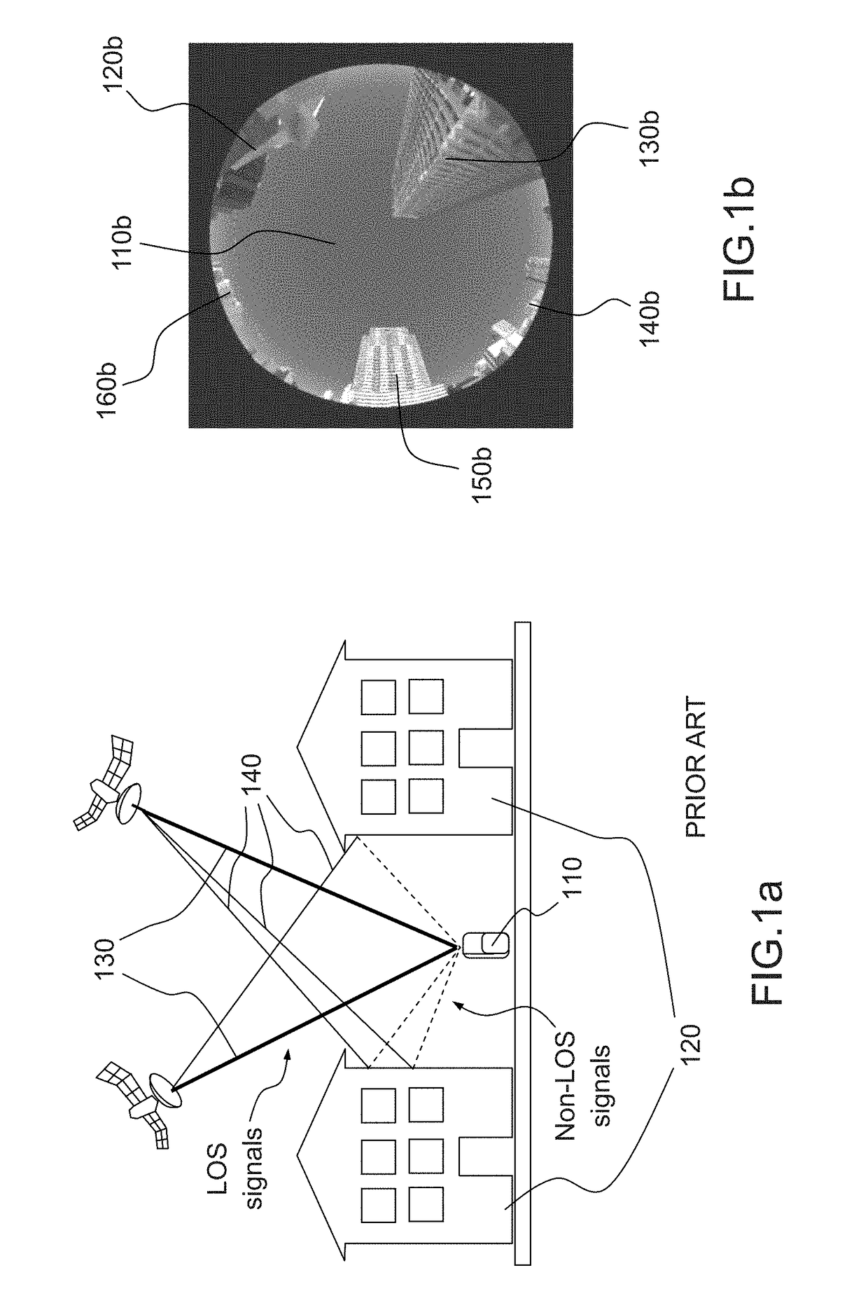
[0047]FIGS. 1a and 1b illustrate the problem of LOS / non-LOS communication in the prior art which is addressed by the invention.

[0048]On FIG. 1a, a receiver 110a is positioned between two buildings 120a. Certain signals 130a reach the receiver in a direct line. Other signals 140a reach the receiver after having been reflected from the buildings. A standard receiver is not able to make a difference between direct signals 130a and reflected signals 140a, thereby leading to a positioning error. Multipath errors at a given location of the receiver 110a will depend on the characteristics of the obstacles at the location (height, roughness of their surface, etc. . . . ) but also on the elevation of the satellites in view, and therefore on the time of the day, and on the meteorological conditions.

[0049]It is quite difficult to correct multipath errors, notably because they are location and time dependent and therefore require significant memory and / or processing power. Also, receivers which...


PUM


Abstract

The invention discloses an antenna assembly comprising one or more sensors, possibly a fish-eye camera which produces images of the sky above the antenna, said images being processed to identify open sky and occulted sky areas, said identification being used to generate an antenna gain pattern shape wherein null zones are placed on the occulted sky areas, so as to eliminate the GNSS signals which are affected by multi-path reflection. The antenna assembly of the invention may be used with any GNSS receiver of the prior art. No specific data on the location of the receiver or its orientation is needed to perform the method of the invention, while in some embodiments, it may be useful to send some information on the number of satellites in view in the open sky.

Description

FIELD OF THE INVENTION[0001]The invention relates to an antenna assembly for a GNSS receiver. More specifically the radiation pattern of the antenna in the antenna assembly may be adapted or reconfigured to provide a higher proportion of Line Of Sight (LOS) signals to a standard GNSS receiver which will then be better protected against non-LOS signals which can degrade the overall precision of the navigation system.BACKGROUND[0002]The use of navigation receivers becomes increasingly pervasive in everyday life. It is all the more common that cars' on-board electronics, smart phones, tablets include navigation receivers, and that applications running thereon capture as input information on position and trajectory of the user of the terminal.[0003]Navigation receivers rely on L-Band RF (radio frequency) signals transmitted by Medium Earth Orbiting satellites, which are generally included in constellations comprising tens of them to cover most of the surface of the earth, such as the GP...

Claims


Application Information

Patent Timeline
Patent Type & Authority Applications(United States)
IPC IPC(8): G01S19/22H01Q3/36G01S13/86G01S17/86H04N5/232H04N5/33
CPCG01S19/22H01Q3/36H04N5/33G01S17/023H04N5/23238G01S13/86G01S19/13G01S19/21H04N23/23G01S19/26G01S19/36H01Q1/42H01Q9/27H01Q1/24G01S17/86H04N23/698
Inventor CAPET, NICOLASMARMET, FRANCOIS-XAVIER
Owner CENT NAT DETUD SPATIALES C N E S
Learn More