Navigation system utilizing yaw rate constraint during inertial dead reckoning

a navigation system and inertial dead reckoning technology, applied in surveying navigation, navigation instruments, instruments, etc., can solve the problems of inability to accurately determine the direction of the vehicle, the accuracy of the ins-based position, the adverse influence of velocity and attitude, and the relative low cost of imu

Active Publication Date: 2018-10-11
NOVATEL INC
View PDF26 Cites 16 Cited by
  • Summary
  • Abstract
  • Description
  • Claims
  • Application Information

AI Technical Summary

Problems solved by technology

The gyroscopes in the IMU, particularly in a relatively low cost IMU, tend to have very large biases and can drift quickly when left un-aided by the GNSS information.
Accordingly, without the GNSS updates, the accuracy of the INS-based position, velocity and attitude is adversely affected.
In particular, uncorrected gyroscope measurements result in determinations of inaccurate vehicle heading which is one of the major sources of error in the calculations of INS-based position, velocity and attitude.
When the outage of GNSS information lasts for much longer periods of time due, for example, to the GNSS antenna falling off of the vehicle or the GNSS antenna otherwise becoming disabled, or interference such as jamming in the area, the GNSS / INS navigation system must continue to operate with inertial sensors that have unchecked drift errors over many measurement intervals.
The increasingly larger drift errors adversely affect the accuracy of the operations of the system and, in particular, result in increasing inaccuracies in the determination of vehicle heading.
This in turn leads to greater errors in the calculation of the INS-based position, velocity and attitude.
However, the specialized instrumentation adds to the cost and complexity of the vehicle, and thus, such instrumentation is not typically included.
Accordingly, the drift errors of the INS sensors and the associated inaccuracies in the calculation of position, velocity and attitude may result in the vehicle navigation and control systems determining that the vehicle has turned, when the vehicle is actually proceeding in the same direction.
Alternatively, the control system may erroneously determine that the vehicle has not turned when, in fact, the vehicle has turned.
Either inaccuracy adversely affects the operations of vehicle navigation and / or vehicle control by the navigation / control system.
If the yaw rate exceeds the turn rate threshold, the system does not perform a zero yaw rate update and the sensor drift error remains unchecked for the mechanization update interval.

Method used


Image

  • Navigation system utilizing yaw rate constraint during inertial dead reckoning
  • Navigation system utilizing yaw rate constraint during inertial dead reckoning
  • Navigation system utilizing yaw rate constraint during inertial dead reckoning

Examples


Embodiment Construction

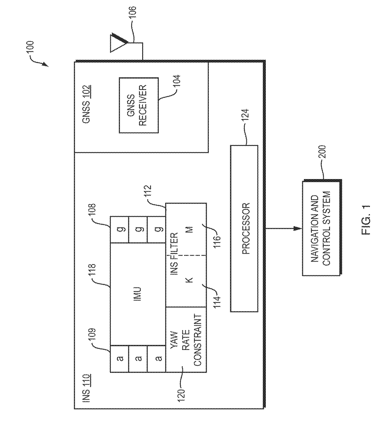
[0015]Referring now to FIG. 1, a GNSS / INS navigation system 100 for use with a driver controlled or driverless / autonomous vehicle (not shown) includes a GNSS subsystem 102 and an INS subsystem 110. The GNSS subsystem 102 includes a GNSS receiver 104 that operates in a known manner to process GNSS satellite signals that are received by a GNSS antenna 106 and produce GNSS raw measurements, such as pseudoranges, carrier phases, and Doppler velocities; GNSS position, velocity and time, and position covariance; and, as appropriate, GNSS observables. The GNSS raw measurements, GNSS position, velocity and time, and the position covariance and the GNSS observables are hereinafter referred to collectively as “GNSS measurement information.”

[0016]The INS subsystem 110 includes an inertial measurement unit (IMU) 118 that reads data from orthogonally positioned INS sensors, which consist of accelerometers 109 and gyroscopes 108, and produces INS measurements. An INS filter 112 processes the GNSS...


PUM


Abstract

A system operating in a dead reckoning mode accumulates relative yaw measurements, i.e., measurements of rotation about a z-axis, made by one or more over mechanization update intervals and produces dead reckoning mechanization update values. The system accumulates the values over a turn rate accumulation period, calculates a yaw rate and determines if the yaw rate exceeds a turn rate threshold. If so, the system directs an INS filter to perform a zero yaw rate update at the start of a next mechanization update interval, to correct for the z-axis drift errors of the gyroscopes based on the sensed rotation in the relative yaw measurements over the previous mechanization update interval. The system then sets the z-axis drift errors to zero. If the system determines that the yaw rate exceeds the turn rate threshold, the zero yaw rate update is not performed at the start of the next mechanization update interval.

Description

BACKGROUNDTechnical Field[0001]The invention relates to GNSS / INS navigation systems and, in particular, to GNSS / INS navigation systems that utilize a yaw rate constraint during dead reckoning.Background Information[0002]GNSS / INS navigation systems, such as the systems described in U.S. Pat. Nos. 6,721,657 and 7,193,559, which are assigned to a common assignee and incorporated herein by reference, may be used in vehicles to aid in navigation and also in the control of the vehicles. The GNSS / INS navigation systems work well to provide accurate up-to-date INS-based position, velocity and attitude information to a vehicle navigation and control system that, in turn, provides navigation information to a user directly or via a map. Alternatively, or in addition, the vehicle navigation and control system may utilize the navigation information to control the vehicle.[0003]A GNSS subsystem of the GNSS / INS navigation system receives GNSS satellite signals and, operating in a known manner, pro...

Claims


Application Information

Patent Timeline
Patent Type & Authority Applications(United States)
IPC IPC(8): G01C21/18G01C25/00G01S19/47
CPCG01C21/18G01C25/005G01S19/47G01C21/165
Inventor BOBYE, MICHAEL
Owner NOVATEL INC
Why Eureka
Try Eureka