Method and system for classifying vehicle based road sign observations

a technology of road sign and classification method, applied in relational databases, navigation instruments, instruments, etc., to achieve the effect of better visualization of speed limit data

Active Publication Date: 2020-01-16
HERE GLOBAL BV
View PDF0 Cites 3 Cited by
  • Summary
  • Abstract
  • Description
  • Claims
  • Application Information

AI Technical Summary

Benefits of technology

[0005]Further, there is a need to provide more accurate classification of road signs, such as static signs and VSSs for providing better visualization of speed limit data on a map interface of a navigation device.

Problems solved by technology

The major problem affecting accuracy of road sign data is that reporting vehicles can observe speed values that are displayed on variable speed sign (VSS) gantries and report them as static speed limits.
The problem discussed above arises when a VSS is misclassified as a static sign by the vehicle, and the misclassification causes road sign permanency flag to be set as static.

Method used


Image

  • Method and system for classifying vehicle based road sign observations
  • Method and system for classifying vehicle based road sign observations
  • Method and system for classifying vehicle based road sign observations

Examples


Embodiment Construction

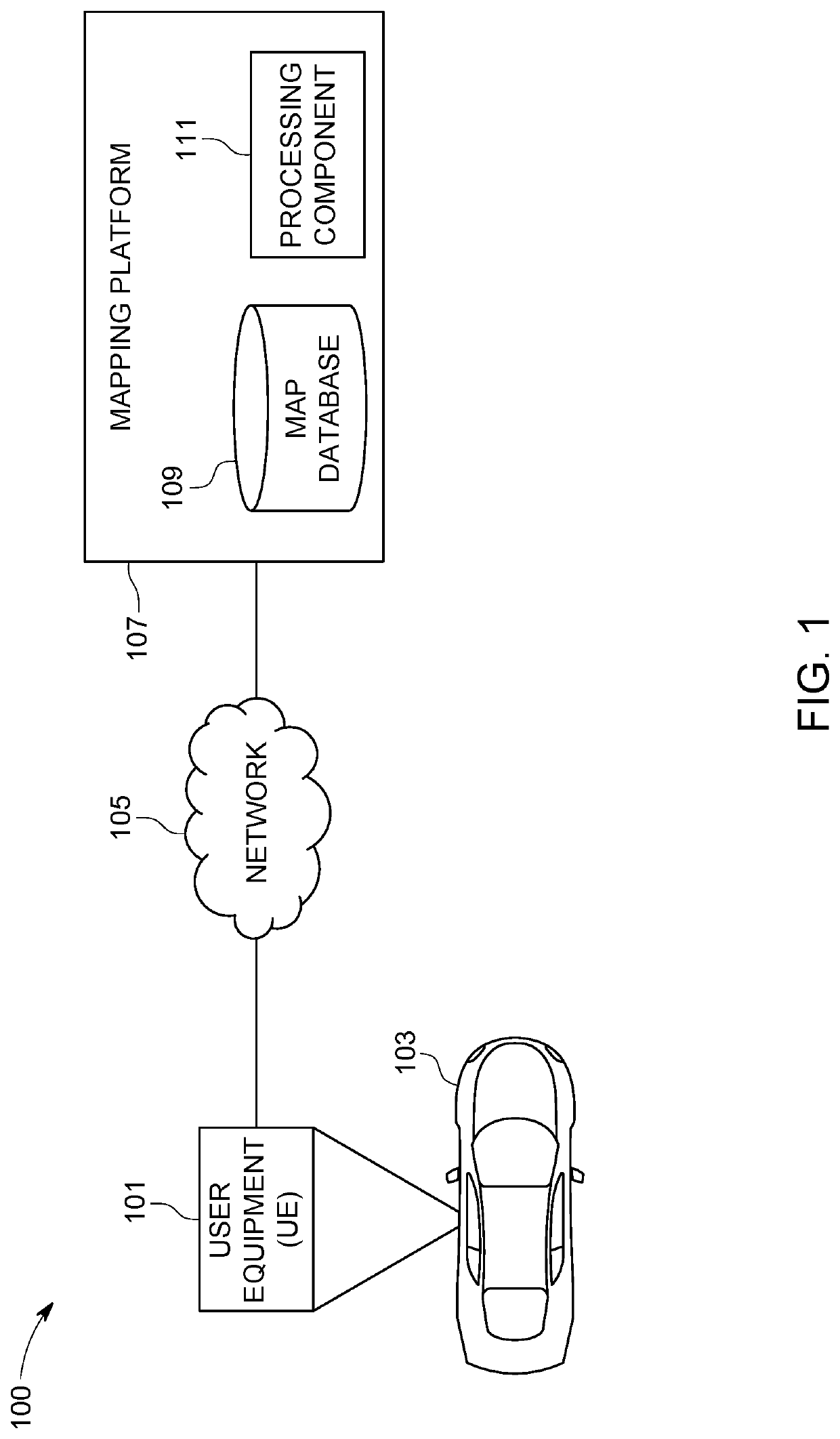
[0019]Some embodiments of the present invention will now be described more fully hereinafter with reference to the accompanying drawings, in which some, but not all, embodiments of the invention are shown. Indeed, various embodiments of the invention may be embodied in many different forms and should not be construed as limited to the embodiments set forth herein; rather, these embodiments are provided so that this disclosure will satisfy applicable legal requirements. Like reference, numerals refer to like elements throughout. As used herein, the terms “data,”“content,”“information,” and similar terms may be used interchangeably to refer to data capable of being transmitted, received and / or stored in accordance with embodiments of the present invention. Thus, use of any such terms should not be taken to limit the spirit and scope of embodiments of the present invention. A method, apparatus, and computer program product are provided herein in accordance with an example embodiment fo...


PUM


Abstract

A method, system, and computer program product is provided, for example, for filtering road signs. The method comprises receiving a road sign observation information from a vehicle on a link. The road sign information includes at least a location of the vehicle. The method further comprises retrieving a sign file information from a database. The sign file information includes location of a plurality of VSS gantries in a geographical region. The method further includes filtering the road sign observation information if the location of the vehicle is within a predetermined distance threshold from at least one VSS gantry from the plurality of VSS gantries in the geographical region.

Description

TECHNOLOGICAL FIELD[0001]The present disclosure generally relates to a system and method for providing assistance to a driver of a vehicle or the vehicle itself, and more particularly relates to a system and method for using a map database for classifying traffic signs related information for vehicles on a link.BACKGROUND[0002]Map based applications are used in many navigation applications in vehicles. The map can be used as a source of speed limit information, road sign information, variable speed sign (VSS) related information, and direction related information for traffic signs, such as speed signs posted on gantries and the like. The navigation applications rely on map data for performing various navigation assisted functions. Thus, the map database should be provided with accurate and up-to-date data.[0003]The map database may receive data related to road signs, which can be static signs or VS Ss posted on gantries, via ingestion of vehicle smart sensor data (sensor data) and a...

Claims


Application Information

Patent Timeline
Patent Type & Authority Applications(United States)
IPC IPC(8): G06F17/30G01C21/26
CPCG01C21/26G06F16/29G06F16/9537G06F16/2379G06F16/285G06F16/162G06F16/148G01C21/3602G01C21/3807
Inventor ZHANG, ZHENHUASTENNETH, LEON
Owner HERE GLOBAL BV
Why Eureka
Try Eureka