
Spatial queries

a spatial data and querying technology, applied in the field of spatial data and querying spatial data, can solve the problems of difficult reuse of these implementations for other similar queries, rigid and hard-to-expand approaches in these systems, and restricted support of specific queries

Active Publication Date: 2020-10-29
NEW YORK UNIV
View PDF2 Cites 1 Cited by
  • Summary
  • Abstract
  • Description
  • Claims
  • Application Information

AI Technical Summary

Benefits of technology

The patent describes a new way to represent geometrical objects and a small set of operators that can handle a wide range of spatial queries. The new representation allows for a uniform representation of different geometrical objects and allows for the same set of operators to be used for different types of spatial queries. This increases efficiency and flexibility in creating and using spatial queries.

Problems solved by technology

reference).) While some of them also provide their own database solution, their support is restricted to specific queries that support the required f
This makes the approaches in these systems rigid and hard to extend; it is difficult to reuse these implementations for other similar queries.
The inherently heterogeneous representations used for the spatial component of the data is also a cause of such rigidity.
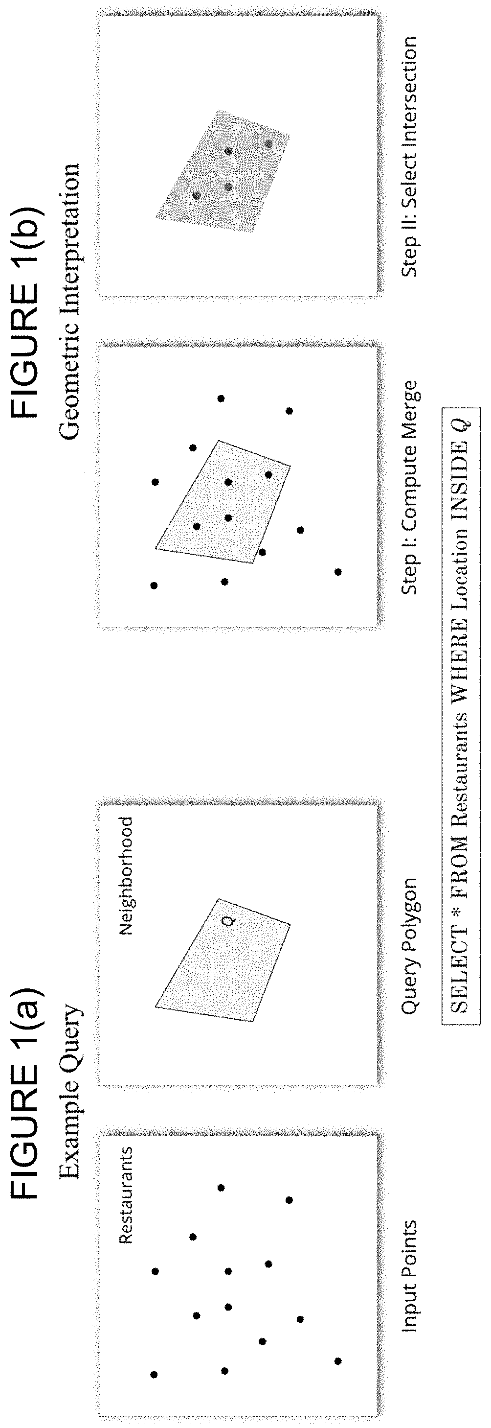
Thus, a technique that works for one geometric type (e.g., points) is not applicable for another type (e.g., polygons), and even small extensions to a query often has to be implemented from scratch (as in the above example, where the input is changed from points to polygons).
This trait also restricts the ways in which complex queries can be composed using the different operators, because these operators themselves correspond to (often complex) queries, each having their own specific implementations.
Therefore, the query optimizer has limited options when deciding the order of spatial operations for a complex query, often resulting in the generation of costly query plans.
Consequently, the execution is sub-optimal and negatively impacts the response time.
However, like previous approaches, RasterJoin works only for one class of queries: namely, spatial aggregations involving point-based and polygon-based data sets.
Current approaches also make it difficult for new advances (e.g., using modern hardware such as graphics processing units or GPUs) proposed for one type of query to be carried over to other similar queries.
While concepts introduced in these approaches (e.g., GPU-friendly indexes, computing spatial intersections) can be useful for other queries, because the different query evaluation strategies are atomic, it is not possible to reuse them.
This makes it difficult to work with complex spatial objects.
Second, computing the relationships requires costly intersection tests to be performed between every pair of spatial objects, making the approach untenable for working with large spatial data sets.
Third, and more importantly, while intersection-based queries are straightforward, queries such as distance joins between points, or nearest neighbors, etc., cannot be expressed using this model.
Given this representation, there is a loss of accuracy introduced in the query results.
However, trying to overcome this using very small rectangles can result in a high memory overhead, and also requires expensive set operations making the practical applicability of this approach impractical.
There are several problems with this framework.
First, even though the redrawing operation ensures that queries involving intersection tests can be efficiently and precisely computed using only integer operations, due to the distortion involved, other queries which involve any kind of distance as part of the query (e.g., distance join, nearest neighbor) cannot be accurately computed.
Third, queries involving spatial objects outside the Realm boundaries are not possible.
This is a major drawback in modern exploratory data analysis tasks where users can dynamically change their focus depending on their ongoing analysis.
Finally, similar to the extended relational models, there are separate data types for points, lines, and polygons, thus making the implementation specific to these data types, and also making it difficult to incorporate complex spatial objects composed of more than one type.
But at the same time, leveraging these hardware not only requires multiple implementations of spatial operations, but their implementations are also complex, especially when using hardware such as modern GPUs.

Method used


Image

  • Spatial queries
  • Spatial queries
  • Spatial queries

Examples


example implementation

[0042]Example implementation strategies are described, including a subset of the proposed operators that demonstrates: (1) how the proposed geometric data representation and composable operators are naturally suited for GPUs; and (2) how example composable operators can be re-used in different queries. Example implementations consistent with the present description achieve over two orders of magnitude speedup over a custom CPU-based implementation, and consistently outperforms custom GPU-based approaches as well. (See § 4.4.2.)

[0043]The compatibility of the proposed operations with the relational model and its utility for query optimization is discussed. (See § 4.4.5.)

§ 4.1 Definitions and Representation of Spatial Data

[0044]§ 4.1.1 Data Representation

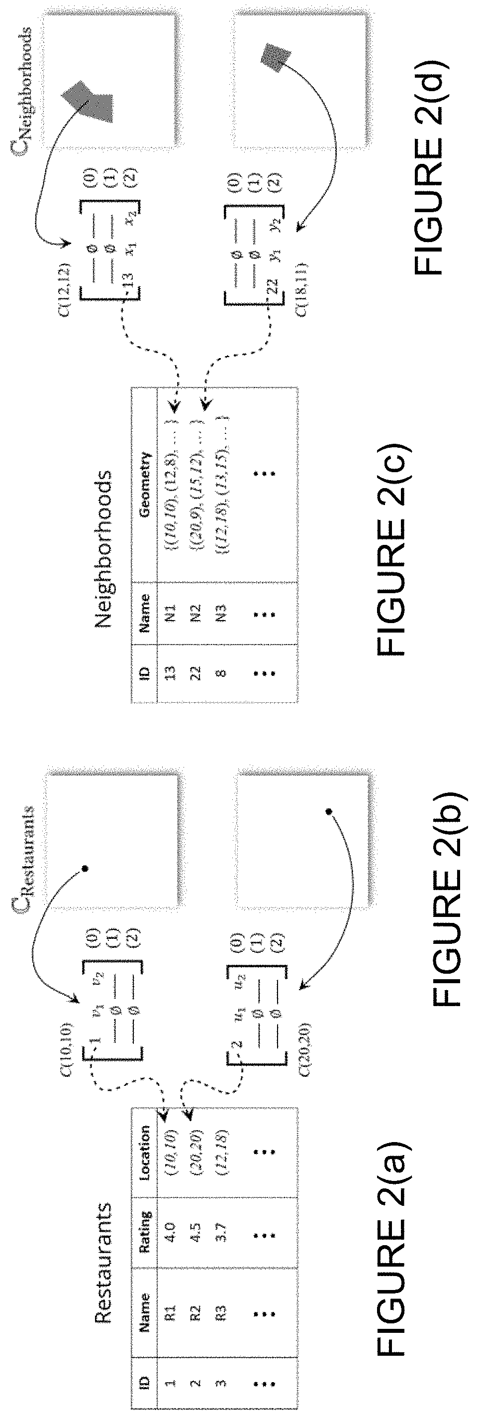
[0045]This section formalizes the notion of a spatial data set, and then defines the concept of a canvas, the spatial analogue of a relational tuple.

[0046]§ 4.1.1.1 Spatial Data

[0047]As discussed in § 1.2 above, the inventors believe t...


PUM


Abstract

Advances in technology and the availability of low cost sensors have led to an unprecedented growth in the volume of spatial data. Unfortunately, the time required to evaluate even simple spatial queries over large data sets greatly hampers the ability to interactively explore these data sets and extract actionable insights. While modern hardware (such as Graphics Processing Units or GPUs) are increasingly being used to speed up spatial queries, existing solutions have two important drawbacks: they are often tightly coupled to the specific query types they target, making it hard to adapt them for other queries; and since their design is based on CPU-based approaches, it can be difficult to effectively utilize all the benefits provided by the said hardware. To overcome these issues, spatial data are represented as geometric objects and a set of composable operators that operate over these objects are defined. The expressiveness of the proposed representation is demonstrated by realizing standard spatial queries as a composition of the proposed operators. To illustrate the performance gains that can be attained, a proof-of-concept GPU-based implementation focusing on a subset of the operators was built and evaluated.

Description

§ 0. RELATED APPLICATION(S)[0001]This application claims the benefit of U.S. Provisional Patent Application Ser. No. 62 / 840,377 (referred to as “the '377 provisional” and incorporated herein by reference), filed on Apr. 29, 2019, titled “IMPROVING SPATIAL QUERIES” and listing Harish DORAISWAMY and Juliana FREIRE as the inventors. Each of the references cited in the '377 provisional is incorporated herein by reference. The present invention is not limited to requirements of the particular embodiments described in the '377 provisional.§ 1. BACKGROUND OF THE INVENTION§ 1.1 Field of the Invention[0002]Example embodiments consistent with the present description concern spatial data and querying spatial data.§ 1.2 Background Information[0003]Advances in technology and the availability of low cost sensors such as GPS in vehicles and mobile devices has led to an unprecedented growth in the volume of spatial data. These include data captured by social media applications (e.g., Twitter, Insta...

Claims


Application Information

Patent Timeline
Patent Type & Authority Applications(United States)
IPC IPC(8): G06F16/9537G06F16/29G06F16/26G06F16/9538G06T1/20
CPCG06F16/29G06T1/20G06F16/9538G06F16/9537G06F16/26
Inventor DORAISWAMY, HARISHFREIRE, JULIANA
Owner NEW YORK UNIV
Learn More