Methods and apparatus for geospatial data generation

a geospatial data and data generation technology, applied in the field of geospatial data and analytics, can solve the problems of localized inaccuracy, different look angles for imagery and lidar, holes or “occlusions”, etc., to achieve accurate coloration of the sides of objects, reduce occlusion, and effectively fill the hole

Pending Publication Date: 2022-02-10
NV5 GEOSPATIAL INC
View PDF0 Cites 0 Cited by
  • Summary
  • Abstract
  • Description
  • Claims
  • Application Information

AI Technical Summary

Benefits of technology

[0005]In the present disclosure, the ray tracing approach to colorization effectively performs a localized rectification of every pixel using each lidar point, thereby joining the lidar to the imagery not by horizontal position—as done in traditional colorization—but by the vector (or ray) of collection. This results in a colorized lidar dataset with minimized occlusion where there are overlapping images by effectively filling the hole created by building lean with an adjacent frame with a different look angle at the scene. This results in a final product that approximates a True Orthophoto. Additionally, ray tracing colorization is able to more accurately color the sides of objects where multiple look angles exist from the raw image frames.

Problems solved by technology

Traditional methods of spectral assignment from imagery rely on surface generation for rectification, but can result in localized inaccuracies due to feature lean and occlusion.
This process is further complicated by the flight plans for lidar and imagery collection differing significantly, resulting in drastically different look angles for imagery and lidar.
For objects towards the edge of a collected frame, this offset is significant, resulting in holes or “occlusions” in the dataset when used to colorize lidar points that lie near a leaning or tilted tree, building, or other relatively tall object.

Method used


Image

  • Methods and apparatus for geospatial data generation
  • Methods and apparatus for geospatial data generation
  • Methods and apparatus for geospatial data generation

Examples


Embodiment Construction

[0022]The description of the preferred embodiments is intended to be read in connection with the accompanying figures, which are to be considered part of the entire written description of these disclosures. While the present disclosure is susceptible to various modifications and alternative forms, specific embodiments are shown by way of example in the drawings and will be described in detail herein. It should be understood, however, that the present disclosure is not intended to be limited to the particular forms disclosed. Rather, the present disclosure covers all modifications, equivalents, and alternatives that fall within the spirit and scope of these exemplary embodiments.

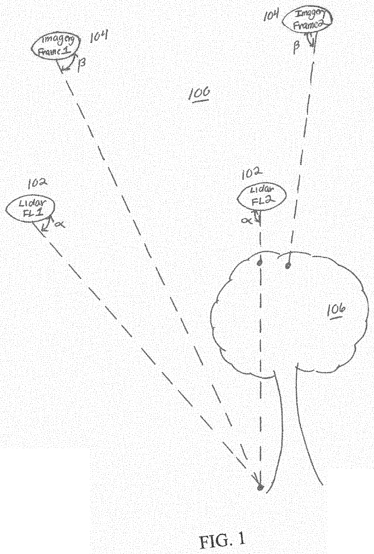
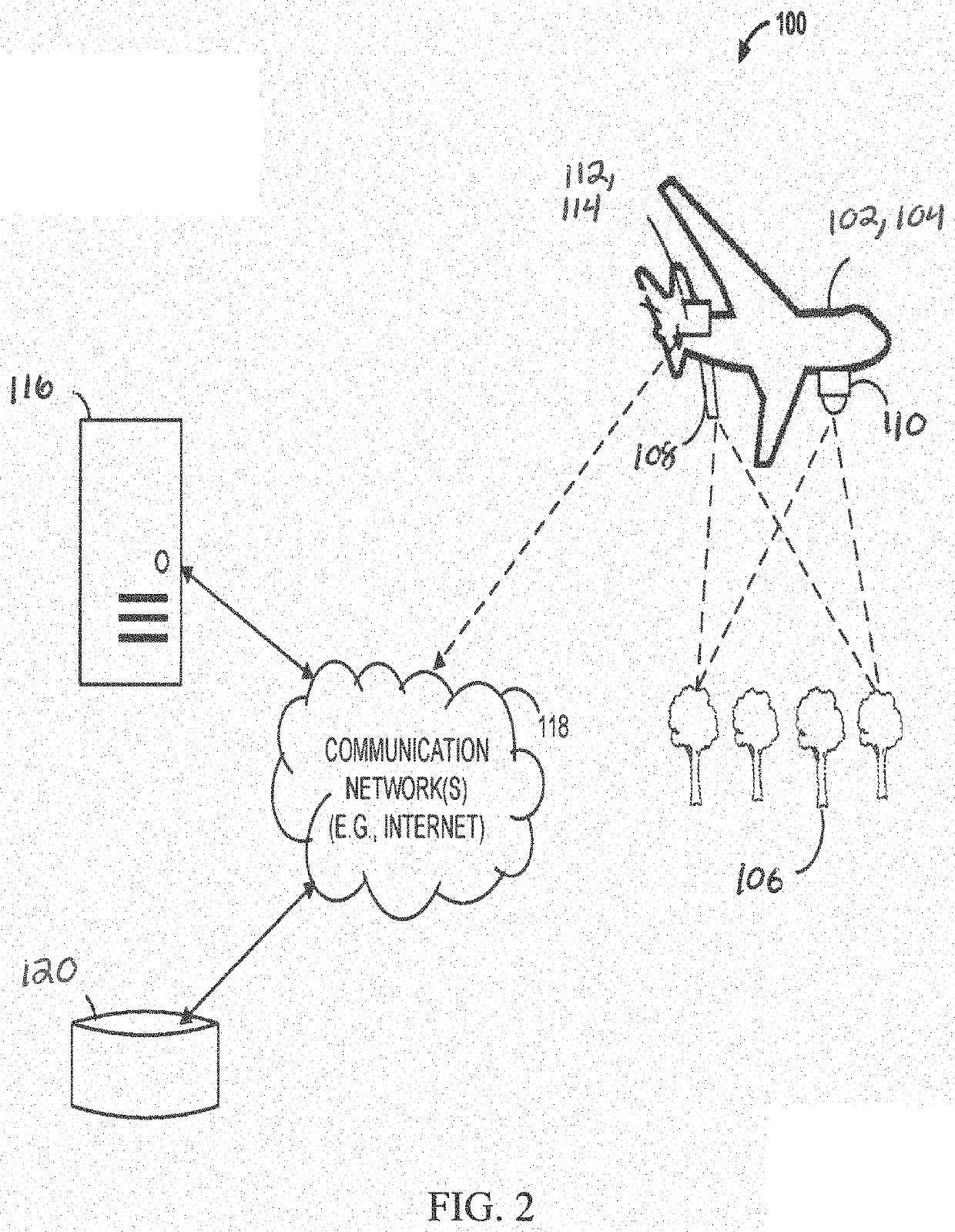
[0023]Referring now to the figures in which like reference designators refer to like elements, there is shown in, FIGS. 1 and 2 diagrams of a geospatial data capture system 100. The geospatial data capture system 100 can include multiple aircraft 102, 104 flying over a scene (e.g., trees) 106. The aircraft 10...


PUM


Abstract

A system and method of generating enhanced lidar data for a scene is provided. The system having a lidar point collection system, with a lidar sensor and a lidar point processing system, and an image collection system with an image sensor and an image processing system. The lidar point collection system can obtain lidar data of the scene with the lidar sensor, and the image collection system can obtain a plurality of images of the scene with the image sensor. The system further has a processing system for comparing the collected lidar data and plurality of images to generate enhanced lidar data of the scene.

Description

CROSS-REFERENCE TO RELATED APPLICATION[0001]This application claims the benefit of U.S. Provisional Application No. 63 / 061,117 entitled METHODS AND APPARATUS FOR GEOSPATIAL DATA GENERATION, filed on Aug. 4, 2020, the content of which is herein incorporated by reference in its entirety.FIELD OF THE INVENTION[0002]The disclosure relates generally to geospatial data and analytics and, more particularly, to the generation of geospatial data.BACKGROUND OF THE INVENTION[0003]The full possibilities of derived analytics from remotely sensed data often depend on fusion of data from multiple sensors. Lidar provides significant structural information, but little spectral information relative to imagery sensors. Accurate assignment of spectral information directly to lidar point clouds further enables feature extraction, classification, visualization, and analysis beyond lidar or imagery alone. Traditional methods of spectral assignment from imagery rely on surface generation for rectification,...

Claims


Application Information

Patent Timeline
Patent Type & Authority Applications(United States)
IPC IPC(8): G01S17/89G06T7/20G06T7/70G06K9/62
CPCG01S17/89G06T7/20G06T2207/30241G06K9/6202G06K9/6228G06T7/70G06V10/28G06V20/17G06T7/00G06T2207/10028G06T2207/10032G01S7/4808G01S17/86G06V10/751G06F18/211
Inventor HEY, MISCHAEVELY, CHAD
Owner NV5 GEOSPATIAL INC
Why Eureka
Try Eureka