Intelligent geographic locating system by imaging of sky, and method for geographic locating

a geographic positioning and intelligent technology, applied in the field of systems and methods for geographic positioning for navigation by reference to the sky, can solve problems such as inability to accurately perform, physical and sighting errors, and calculation errors that may be expected, and achieve reliable results

Pending Publication Date: 2022-04-14
TERRADEPTH INC
View PDF0 Cites 1 Cited by
  • Summary
  • Abstract
  • Description
  • Claims
  • Application Information

AI Technical Summary

Benefits of technology

[0006]In one aspect, embodiments according to this disclosure may include improved systems and methods for geographic locating in navigation, by capturing sky images. In an aspect, embodiments may include such improved systems and methods for geographic locating in

Problems solved by technology

Use of a sextant to navigate by reference to celestial objects requires knowledge of celestial objects, training in the use of star charts, is time intensive, generally cannot be performed in a reliable manner by an inexperienced person, and is subject to inadvertent introductio

Method used


Image

  • Intelligent geographic locating system by imaging of sky, and method for geographic locating
  • Intelligent geographic locating system by imaging of sky, and method for geographic locating
  • Intelligent geographic locating system by imaging of sky, and method for geographic locating

Examples


Embodiment Construction

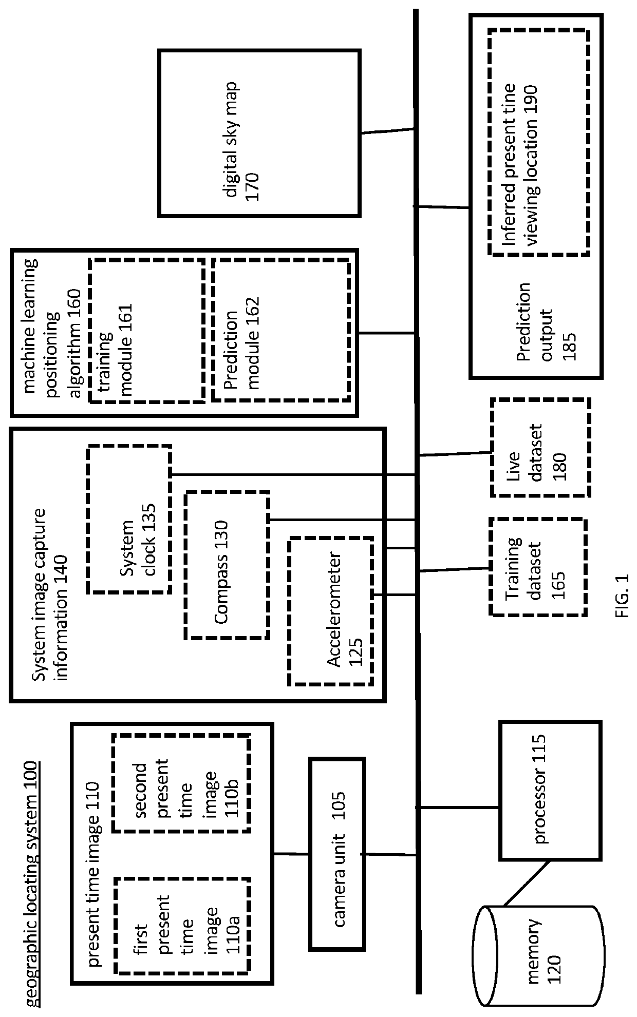
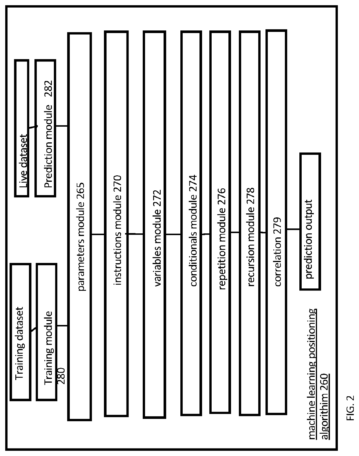
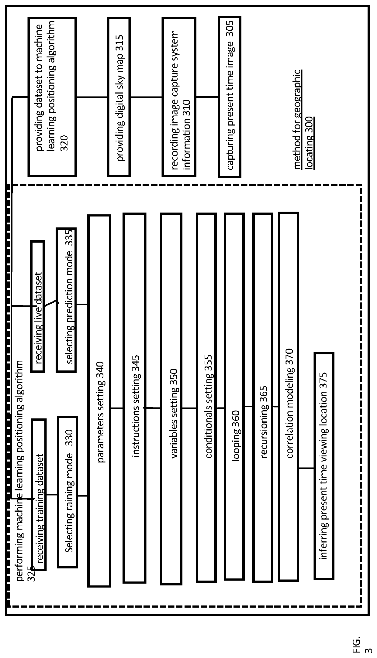
[0015]In the following detailed description, reference is made to the accompanying drawings which form a part hereof, and in which is shown by way of illustration specific embodiments which may be practiced. These embodiments are described in sufficient detail to enable those skilled in the art to practice the embodiments and disclosure. It is to be understood that other embodiments may be utilized, and that logical, mechanical, electrical, and other changes may be made without departing from the scope of the embodiments and disclosure. In view of the foregoing, the following detailed description is not to be taken as limiting the scope of the embodiments or disclosure.

[0016]The terminology used herein is for the purpose of describing particular embodiments only and is not intended to be limiting. As used herein, the singular forms “a”, “an”, and “the” are intended to include the plural forms as well, unless the context clearly indicates otherwise. It will be further understood that...


PUM


Abstract

An autonomous system for geographic locating may include a camera unit capable of capturing a present time image of a night sky, a processor operable to execute instructions accessible in memory, the processor capable of implementing a machine learning positioning algorithm comprising a finite sequence of instructions, the machine learning positioning algorithm comprising a training module operable in a training mode with a training dataset to train same, the machine learning positioning algorithm including a prediction module operable in a prediction mode with a live dataset to provide a prediction of an inferred geographic location of capturing the present time image.

Description

CROSS REFERENCE TO RELATED APPLICATIONS[0001]This application is related and claims priority to U.S. Provisional Application 63 / 089,639 filed Oct. 9, 2020, which is incorporated by reference herein in entirety.FIELD OF THE INVENTION[0002]This disclosure relates generally to systems and methods for geographic locating for navigation. The disclosure, more particularly, relates to systems and methods for geographic locating for navigation by reference to the sky.BACKGROUND OF THE INVENTION[0003]Various systems, apparatus and methods exist for geographic locating in navigation, such as for use aboard transports such as ocean vessels and aircraft (hereinafter “transports”). Systems for geographic locating, for example, may include satellite positioning systems (“GPS”) using signals to and / or from satellites. Prior to the deployment of GPS systems, marine navigation of ships on the oceans often relied on the skilled use of a dual reflection instrument, the sextant, by mariners to navigate...

Claims


Application Information

Patent Timeline
IPC IPC(8): G01C21/02G06N20/00G01C21/16G01C21/24
CPCG01C21/025G01C21/24G01C21/16G06N20/00G01C21/02G01C17/00
Inventor KAUFFMAN, JUDSON A.WOLFEL, JOSEF
Owner TERRADEPTH INC
Why Eureka
Try Eureka