Active separation tracking and positioning system for towed seismic arrays

a positioning system and active separation technology, applied in the direction of instruments, scientific instruments, measurement devices, etc., can solve the problems of unwieldy, cumbersome operation, complex structure of known components,

Inactive Publication Date: 2004-02-10
WESTERNGECO LLC
View PDF16 Cites 146 Cited by
  • Summary
  • Abstract
  • Description
  • Claims
  • Application Information

AI Technical Summary

Benefits of technology

The active tracking and positioning system of the present invention provides a method and apparatus that enables relative positional control of any number of towed seismic streamers. The present invention controls streamer positions horizontally and vertically using active control units positioned on each streamer within the seismic array. The three component (x, y, z) position of each streamer element, relative to the vessel, relative to each other and relative Earth coordinate latitude and longitude is controlled, tracked and stored with respect to time during each seismic data acquisition run. This stored data is referred to as legacy data. Environmental factors (wind speed, currents, temperature, salinity, etc), and maneuverability data for the streamers and geometry of the towed array (cable diameter, array type, deployed configuration, vessel type, device type, etc.) for the seismic data acquisition run are also sensed with respect to time and stored as legacy data. The acquisition of legacy data enables repetition of seismic data acquisition runs.
The present invention provides active streamer positioning devices (ASPDs) as control elements, which are installed on individual streamers comprising an array, alternatively at the diverter position, streamer head, along the length of the streamer or at the tail of the streamer. One or more ASPD is employed on each seismic array. The active control elements are also installed at the head tow point of an array, at the head or tail of one or more streamers comprising an array, and / or along any streamer comprising an element of an array. The control elements attached at the streamer head are alternatively detachably connected to the front of the array to facilitate detachment and removal of a single streamer element from the array during a data acquisition run.
The apparatus and method of the present invention enables a seismic array to be maneuvered as the towing vessel maintains it desired course or as the towing vessel maneuvers to assist in the repositioning of the array during a seismic data acquisition run. The present invention may alternatively employ methods such as force vectoring, active wings, or other known means of changing the spatial or temporal, that is the vertical or z-depth position of the streamer elements comprising the array. In addition to enabling change in the spatial and temporal positions of individual array elements, the tracking and positioning system enables maintenance of specific array position and geometry in the presence of variable environmental factors. In this mode, the control system of the present invention adjusts the lifting force of the streamer to accommodate variations in the tide, real-time current velocity and direction, water depth, towed speed, cable maneuverability, towed direction and water salinity, and salinity variations, all of which may affect the buoyancy and position of the towed seismic array. The salinity of the water in which the array is towed may vary abruptly when a salt water towing operation passes by the mouth of a fresh water supply such as a river. The salinity may diminish considerably in the fresh water region near the mouth of a river, thereby requiring adjustment of the array towing forces to maintain desired array geometry and depth.
The present invention enables repeatable, four-dimensional seismic data acquisition by sensing and storing environmental data, temperature sensitive array maneuverability data and positional tracking data for a towed array and each individual element of the towed array with respect to time. The relative horizontal and vertical positioning of each seismic cable and energy source independent of the streamer attached to the array or streamer is controlled, monitored and stored, along with real-time environmental data during a seismic data acquisition operation. The composite stored data comprises legacy data for the data acquisition run. Thus, a seismic data acquisition run can be duplicated at a later date to reproduce the same array geometry and path during subsequent data acquisition runs, in the presence of varying environmental and maneuverability conditions. That is, a particular seismic data acquisition operation is repeatable based on the legacy data, thereby enabling repeatable four-dimensional data (x, y, z, time) gathering for multiple runs over a seismic target area. The present invention also enables implementation of non-acquisition ancillary array configurations such as augmented array geometry for collapsing or expanding an array during deployment or retrieval. The present invention also enables raising a single array element for retrieval from a deployed array during acquisition.
One array section or one streamer of an array section can be deflected out of the array geometry during a data acquisition run and vertically to the surface for detachment, retrieval and / or maintenance. The present invention also enables compensation for a failed or missing streamer. Streamers adjacent a failed or missing / removed streamer can be moved closer together to compensate for the failed or missing streamer array element with or without removal of the element. This enables repair and / or removal and replacement of such a failed array element during a seismic data acquisition run without interruption of the data acquisition run to repair and or replace the disabled streamer. Runtime removal of streamers and compensation for failed streamers enables continuation of data acquisition without causing the vessel and / or array to deviate from its planned data acquisition path.
The instant invention also enables configuring the towed array geometry to compensate for changing environmental and operational conditions that affect maneuverability. The array geometry can also be configured to increase or decrease the temporal resolution and spacing of the array to avoid ghost notching. Deployment and ancillary configurations are also provided wherein, for example, the width of an array may be increased to reduce chances of streamer tangling during deployment. The present invention also enhances in fill shooting where an optimal path has been selected. The present invention enables movement of the array in conjunction with movement of the vessel along an optimal in fill shooting path. The present invention individually controls positioning of the vessel and positioning of the array. Thus, the present invention also enables the towing vessel to account for a portion of the positioning along the selected optimal in fill path or data acquisition path and positioning of the array to account for the remainder of the positioning along the path. This division of positioning movements between the vessel and the array provides a more flexible and efficient positioning system for use during in fill shooting and / or other data acquisition positioning maneuvers.

Problems solved by technology

With known seismic cable tracking and positioning systems, the location and spacing of system components is limited by the type, size, and length of cables used and by the characteristics of the towing vehicles and other control devices utilized by the known seismic tracking and positioning systems.
Typically, changing the configuration of such a towed streamer array, comprised of known components is a complex, cumbersome, time-consuming operation and can often become somewhat unwieldy.
Moreover, the spatial and temporal positioning capability of known towing and tracking and positioning systems is limited.
There is no known seismic tracking and positioning system that enables independent and relative positioning of individual seismic streamer array elements, for example "birds", seismic streamers, comprising sensors, sources and depth and position controls, for example to configure, manipulate and / or maintain a desired geometry of and within a towed seismic streamer array.
There is also no known seismic tracking and positioning system that enables relative positioning and manipulation of an entire seismic streamer array.
There is also no known tracking and positioning system that enables specification of a plurality of diverse acquisition and ancillary non-acquisition array geometries that facilitates run-time maintenance, retrieval and deployment of a towed seismic array.
It is time consuming, difficult and expensive to interrupt the towing vessel during a data acquisition run.
This process is difficult and time consuming, if not impossible.

Method used


Image

  • Active separation tracking and positioning system for towed seismic arrays
  • Active separation tracking and positioning system for towed seismic arrays
  • Active separation tracking and positioning system for towed seismic arrays

Examples


Embodiment Construction

To one skilled in this art who has the benefit of this invention's realizations, teachings, disclosures, and suggestions, other purposes and advantages will be appreciated from the following description of preferred embodiments, given for the purpose of disclosure, when taken in conjunction with the accompanying drawings. The detail in these descriptions is not intended to thwart this patent's object to claim this invention no matter how others may later disguise it by variations in form or additions of further improvements.

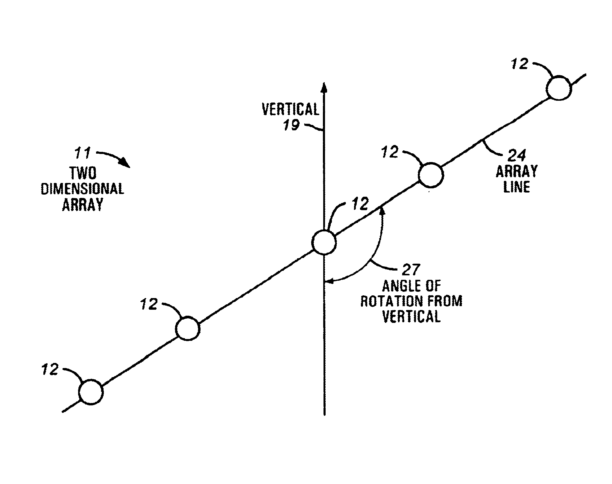
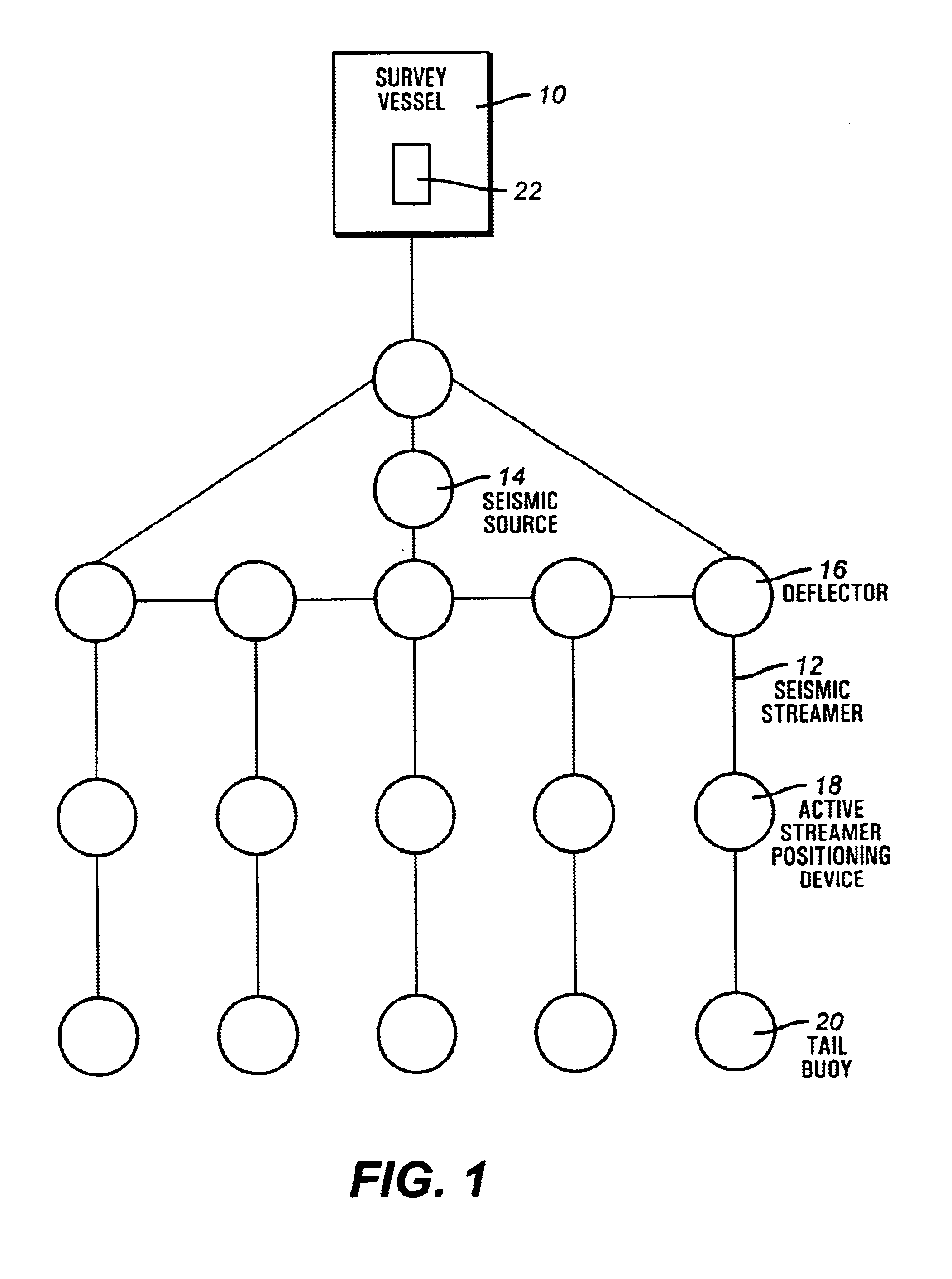
Turning now to FIG. 1, a seismic survey vessel 10 is shown towing a plurality of marine seismic streamers 12 that may, for instance be 3000 meters in length. The outermost streamers 12 in the array can be as much as 400 meters apart, resulting in a horizontal displacement between each streamer of 100 meters, in an equally-spaced array configuration. A seismic source 14, typically an airgun or one or more array of airguns, is also shown towed behind the seismic su...


PUM


Abstract

A method and apparatus comprising an active control system for a towed seismic streamer array that enables any relative positional control of any number of towed seismic streamers. The streamer positions are controlled horizontally and vertically using active control units positioned within the seismic array. The three component (x, y, z) position of each streamer element, relative to the vessel and relative to each other is controlled, tracked and stored during a seismic data acquisition run. The present invention enables a seismic array to be maneuvered as the towing vessel maintains course, enables maintenance of specific array position and geometry in the presence of variable environmental factors and facilitates four-dimensional seismic data acquisition by sensing and storing the position of the array and each array element with respect to time.

Description

The present invention relates generally to a method and apparatus for controlling sea borne seismic data acquisition systems comprising an array of streamers, and in particular to the relative vertical and horizontal positioning of seismic streamers forming a seismic array towed behind a sea borne towing vessel.DESCRIPTION OF THE RELATED ARTThe related art discloses a wide variety of towed marine seismic tracking and positioning systems and methods typically comprising one or more seismic streamers and / or one or more seismic sources. Some these seismic tracking and positioning systems and methods utilize a main or host vessel and / or other-associated unmanned vessels or vehicles to tow the seismic array. Typically towing is controlled or guided by a central control system. The known marine seismic tow tracking and positioning systems and methods are comprised of apparatuses such as seismic hydrophone streamers and attached floats, paravanes, and / or buoyant members. Typically each str...

Claims


Application Information

Patent Timeline
Patent Type & Authority Patents(United States)
IPC IPC(8): G01V1/38
CPCG01V1/3826G01V1/3817
Inventor ZAJAC, MARK
Owner WESTERNGECO LLC
Why Eureka
Try Eureka