Integrated laser mapping tablet and method of use

a laser mapping and tablet technology, applied in the field of digital mapping and data capture, can solve the problems of burdensome number of pieces of equipment required for data capture in digital mapping, difficult to bring into the field, and laborious manual mapping

Inactive Publication Date: 2005-05-17
RUBICON DIGITAL MAPPING ASSOCS
View PDF3 Cites 102 Cited by
  • Summary
  • Abstract
  • Description
  • Claims
  • Application Information

AI Technical Summary

Problems solved by technology

Mapping has traditionally been a laborious manual process.
Prior to the introduction of computers, mapping was a laborious process requiring hand entry of data and measurements using simple tools, such as surveyor instruments, compasses, tape measures, protractors and the like.
However, the number of pieces of equipment required for data capture in digital mapping are burdensome and difficult to bring into the field.
Unless the GPS is interfaced with the computer, the reverence points must be manually entered into the portable computer thus slowing the overall mapping process.

Method used


Image

  • Integrated laser mapping tablet and method of use
  • Integrated laser mapping tablet and method of use
  • Integrated laser mapping tablet and method of use

Examples


Embodiment Construction

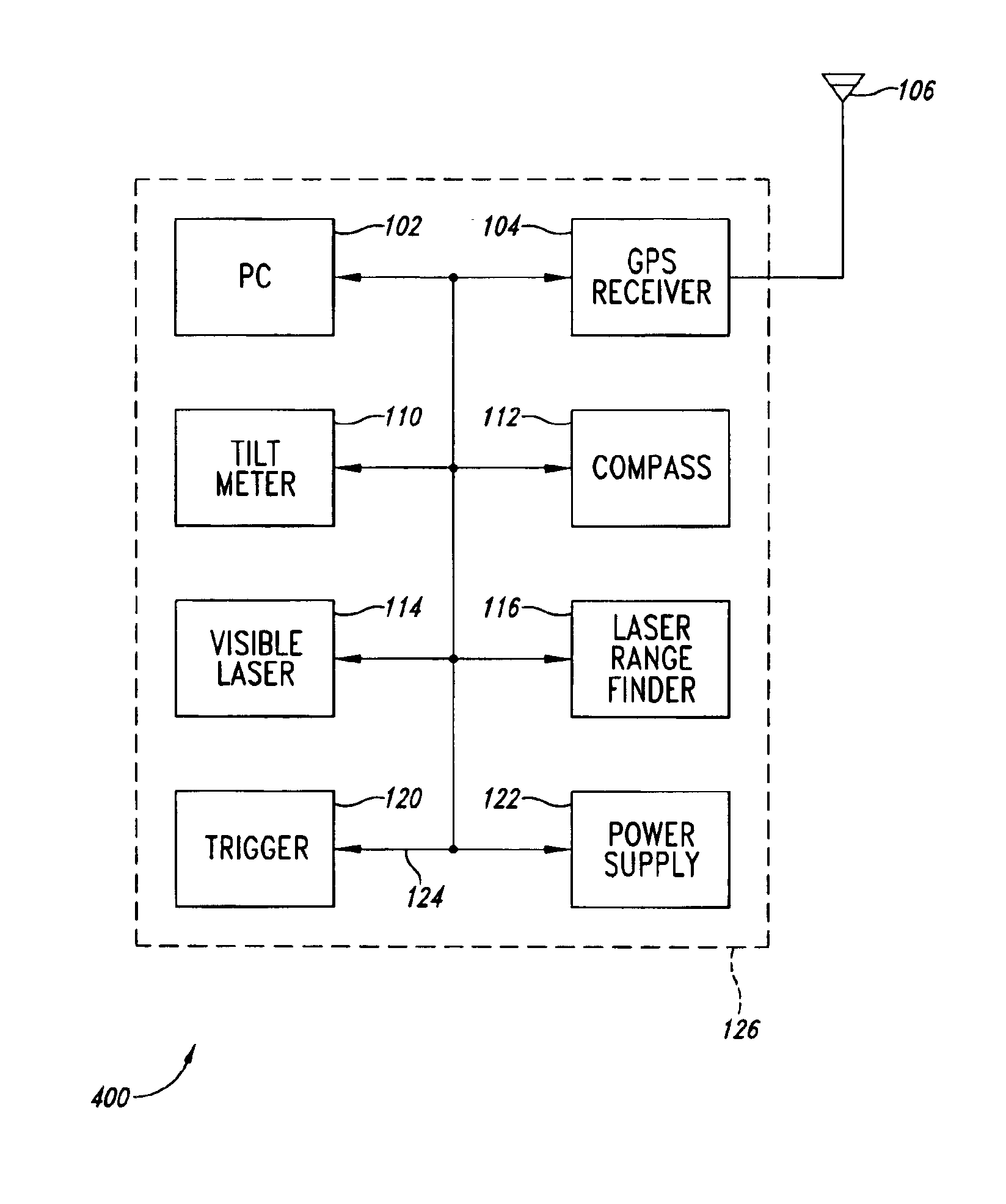
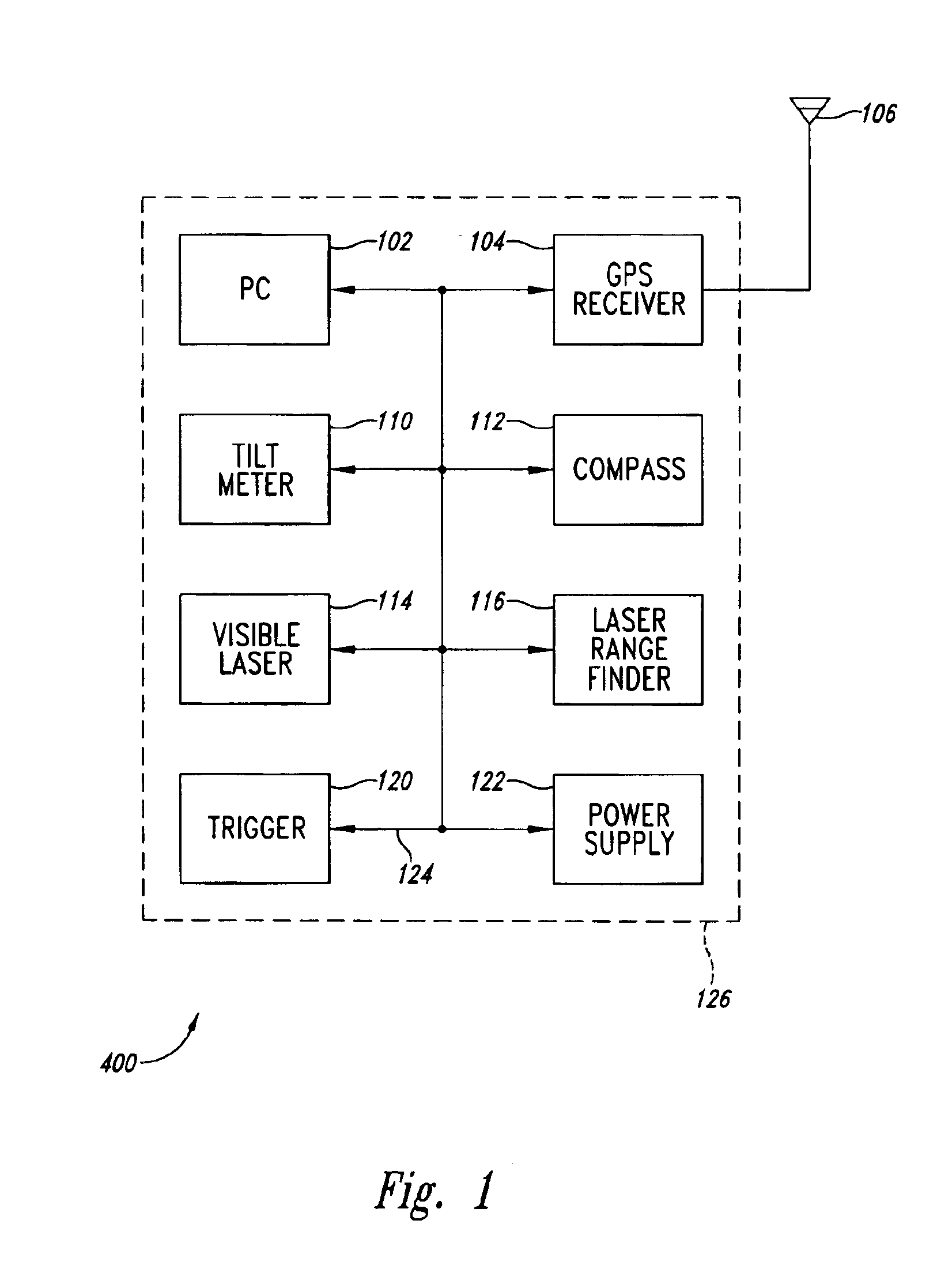
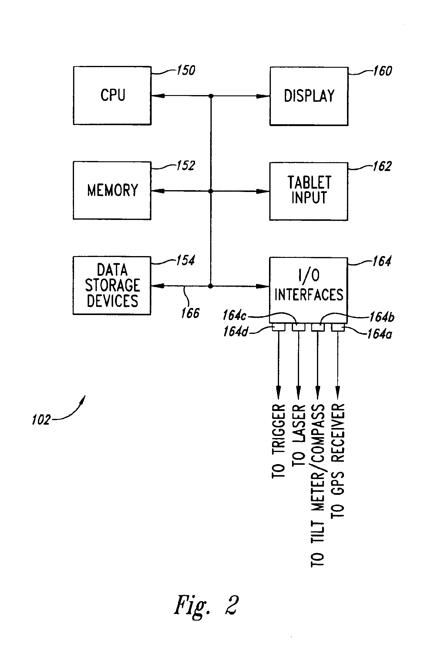
[0026]The present invention is directed to an integrated digital mapping system. A number of separate components are integrated into a single convenient package that allow a high degree of automation in digital mapping. A personal computer (PC) is provided in the form of a pen-tablet computer that allows the user to define selected map features and to set up for automatic data entry. A number of different measurement instruments are integrated into a single housing that also contains the PC. In an exemplary embodiment, the various instruments are triggered by a single source with the result that a plurality of different types of data are collected at the same time and automatically provided to the PC. The data is supplied in various formats that are converted to a single unified format for processing by digital application mapping programs.

[0027]Digital mapping, such as described herein, is useful in the area of geographic information systems (GIS). Digital mapping is also useful in...


PUM


Abstract

An integrated digital mapping device contains a personal pen tablet computer (PC), GPS receiver, tilt meter (liquid filled or accelerometer-based), compass and laser range finder integrated into a single housing. The laser range finder is combined with a visible laser to provide convenient aiming. The device also includes a trigger to initiate a measurement cycle. In response to activation of a measurement cycle, the GPS receiver determines the precise location of the measurement device while the other components provide a measurement of tilt angle (up or down inclination pitch), azimuth, and distance an object or area of interest. The roll (left or right sideways tilt) of the tilt meter also provides information when the tablet is aligned with planar objects. The data from a measurement cycle is converted into a predetermined data format for use with the conventional digital mapping software application program operating within the PC.

Description

BACKGROUND OF THE INVENTION[0001]1. Field of the Invention[0002]The present invention is directed generally to digital mapping and data capture in Geographic Information Systems (GIS), and, more particularly, to an integrated digital mapping apparatus and method of use[0003]2. Description of the Related Art[0004]Mapping has traditionally been a laborious manual process. There are many different types of mapping. These range from maps, such as geopolitical maps to topographic maps. Another type of mapping may typically be used in a localized area, such as a geological map of a region, a watershed map, a mine map, or maps that describe natural resources.[0005]Prior to the introduction of computers, mapping was a laborious process requiring hand entry of data and measurements using simple tools, such as surveyor instruments, compasses, tape measures, protractors and the like. With the advent of portable computers, especially pen tablet computers, digital mapping offers the promise of c...

Claims


Application Information

Patent Timeline
Patent Type & Authority Patents(United States)
IPC IPC(8): G01C17/00G01C9/00H04B7/185G01C15/00G01S17/36G01S17/89G01S19/48
CPCG01C15/002G01S17/89G01S17/36
Inventor BRIMHALL, GEORGERIVERS, MARK
Owner RUBICON DIGITAL MAPPING ASSOCS
Why Eureka
Try Eureka