Method for identifying sedimentary bodies from images and its application to mineral exploration

a technology of image and sedimentary bodies, applied in the field of geologic mapping of sedimentary bodies, can solve the problems of time-consuming and expensive exploration techniques known in the art, and achieve the effect of reducing the cost of exploration and improving the quality of exploration

Inactive Publication Date: 2006-01-10
NASA +1
View PDF3 Cites 10 Cited by
  • Summary
  • Abstract
  • Description
  • Claims
  • Application Information

AI Technical Summary

Benefits of technology

[0010]The invention is a method for identifying a sediment accumulation from an image of a part of the earth's surface. The method includes identifying a topographic discontinuity from the image. A river which crosses the discontinuity is identified from the image. From the image, paleocourses of the river a

Problems solved by technology

The exploration techniques known in the art, however, can be time consuming and expensive, and may ultimately fail to identify certain very large

Method used


Image

  • Method for identifying sedimentary bodies from images and its application to mineral exploration
  • Method for identifying sedimentary bodies from images and its application to mineral exploration
  • Method for identifying sedimentary bodies from images and its application to mineral exploration

Examples


Embodiment Construction

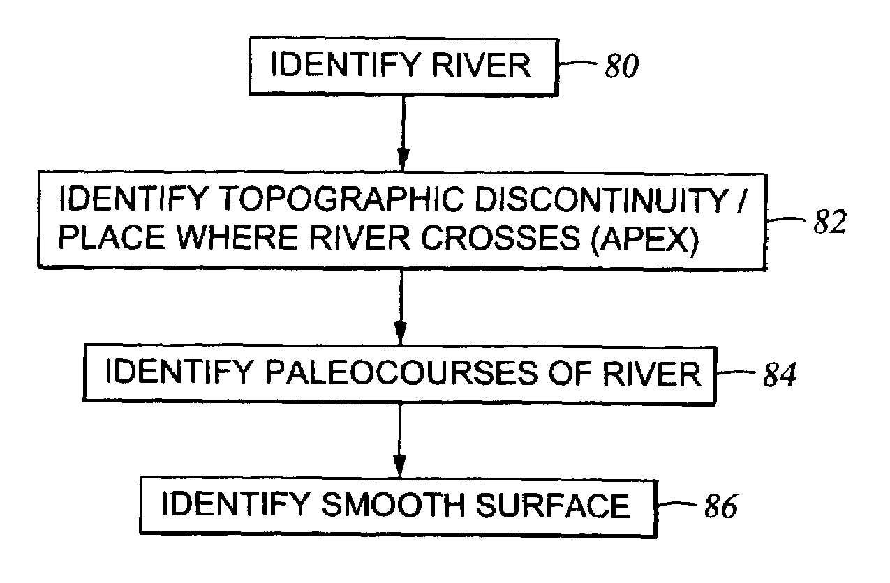
[0026]Generally speaking, embodiments of a method according to the invention use remotely-sensed images of a portion of the earth's surface as input to a process for identifying particular types of sediment accumulations. “Remotely-sensed images” as used herein may include photographs made from atmospheric traveling aircraft, or spacecraft disposed above the earth's atmosphere. “Photographs” as used herein may include conventional photochemical images, or electronically generated, stored and reproduced images such as those made using a charge coupled device (CCD) camera coupled to suitable signal processing and storage circuitry.

[0027]Various embodiments of the invention, as will be further explained, include identification of selected features from the images. Identification of the selected features may include appropriate programming operating on a computer which enables the computer to discriminate portions of the image on the basis of image attributes such as color or brightness...


PUM


Abstract

A method is disclosed for identifying a sediment accumulation from an image of a part of the earth's surface. The method includes identifying a topographic discontinuity from the image. A river which crosses the discontinuity is identified from the image. From the image, paleocourses of the river are identified which diverge from a point where the river crosses the discontinuity. The paleocourses are disposed on a topographically low side of the discontinuity. A smooth surface which emanates from the point is identified. The smooth surface is also disposed on the topographically low side of the point.

Description

CROSS-REFERENCE TO RELATED APPLICATIONS[0001]This invention claims priority from U.S. provisional application Ser. No. 60 / 362,670 filed on Mar. 8, 2002.STATEMENT REGARDING FEDERALLY SPONSORED RESEARCH OR DEVELOPMENT[0002]This invention was made in the performance of work under a NASA contract and is subject to the provisions of Section 305 of the National Aeronautics and Space Act of 1958, Public Law 85-568 (72 Stat. 435, 42 U.S.C § 2457).BACKGROUND OF INVENTION[0003]1. Field of the Invention[0004]This invention relates generally to the field of geologic mapping of sedimentary bodies on the earth's surface. More specifically, the invention relates to techniques for identifying sedimentary bodies and patterns using aerial or space-based images.[0005]2. Background Art[0006]Exploration for minerals, including petroleum, includes as one of several initial tasks identifying geographic areas of the earth in which accumulations of geologically prospective materials is likely. Particularly ...

Claims


Application Information

Patent Timeline
IPC IPC(8): G06K9/00G06V20/13
CPCG06K9/0063G01V99/005G01V2210/661G01V2210/64G06V20/13
Inventor WILKINSON, MURRAY JUSTIN
Owner NASA
Why Eureka
Try Eureka