Multi-gimbaled borehole navigation system

a navigation system and multi-gimbal technology, applied in the field of multi-gimbal borehole navigation system, can solve the problems of insufficient internal diameter of drill pipe to fit the optimal number of typical navigation sensors, and the cost of drilling a borehole at a cost of about $500,000 per day,

Inactive Publication Date: 2006-08-22
CHARLES STARK DRAPER LABORATORY
View PDF26 Cites 59 Cited by
  • Summary
  • Abstract
  • Description
  • Claims
  • Application Information

AI Technical Summary

Benefits of technology

[0012]It is a further object of this invention to provide such a borehole navigation system that can determine position and attitude for any orientation of the borehole navigation system.
[0013]It is a further object of this invention to provide such a borehole navigation system that can average out the navigation errors due to gyro and accelerometer bias errors and average out the navigation errors due to gyro scale factor and input axis alignment errors during navigation of the borehole navigation system.
[0014]It is a further object of this invention to provide such a borehole navigation system that allows gyro and accelerometer bias calibration and gyro scale-factor calibration as well as attitude determination during gyrocompassing.
[0016]It is a further object of this invention to provide such a borehole navigation system that can determine position and attitude while drilling, when the drill bit is stopped, or when the drill bit is inserted or withdrawn.
[0017]It is a further object of this invention to provide such a borehole navigation system that can determine position and attitude while logging, both descending and ascending on a log line after the drill bit has been withdrawn.
[0019]It is a further object of this invention to provide such a borehole navigation system that can effectively control the orientation of the stacked inner gimbals.

Problems solved by technology

One reason is that it is expensive to drill a borehole at a cost of about $500,000 per day.
Many prior art systems have attempted to accurately and efficiently monitor the location of the drill bit to determine its location, but each system has had limitations.
For example, the internal diameter of a drill pipe may not be large enough to fit the optimal number of typical navigation sensors.
A disadvantage of this system is that it is costly to stop drilling and spend time removing the drill bit to take measurements with the monitoring tool.
Prior art systems have used single orientation gyroscopes and / or single orientation accelerometers due to size limitations.
However, these systems can suffer from long-term bias stability problems.
A system such as this, however, does not provide the drill bit's orientation relative to north, which is necessary to determine the full location of a borehole: a system that uses accelerometers is typically only adequate if the oil rig is going to drill a vertical borehole, since an accelerometer system cannot determine north.
Additionally, systems that rely only on magnetometers to determine north can suffer accuracy degradation due to the Earth's changing magnetic field.
Moreover, a navigation system that uses two or more gimbals only requires the sensors to be stable for a few minutes, rather than for days, in comparison to a system that doesn't use gimbals.
However, this system does not allow simultaneous estimation of all sensor biases nor the estimation of the north and the vertical for all borehole orientations.
Other systems have used gimbals within a gyro sensor, but this does not provide all axes of observability.

Method used


Image

  • Multi-gimbaled borehole navigation system
  • Multi-gimbaled borehole navigation system
  • Multi-gimbaled borehole navigation system

Examples


Embodiment Construction

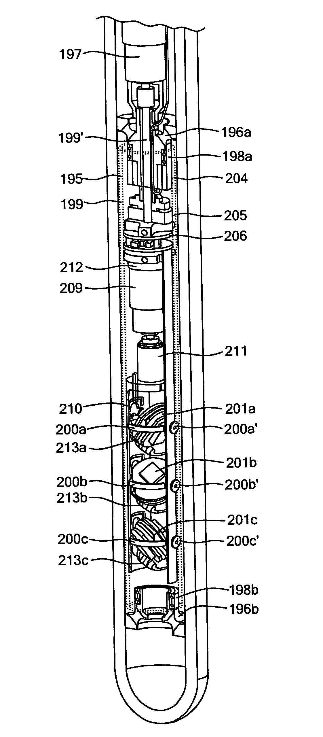
[0047]Aside from the preferred embodiment or embodiments disclosed below, this invention is capable of other embodiments and of being practiced or being carried out in various ways. Thus, it is to be understood that the invention is not limited in its application to the details of construction and the arrangements of components set forth in the following description or illustrated in the drawings.

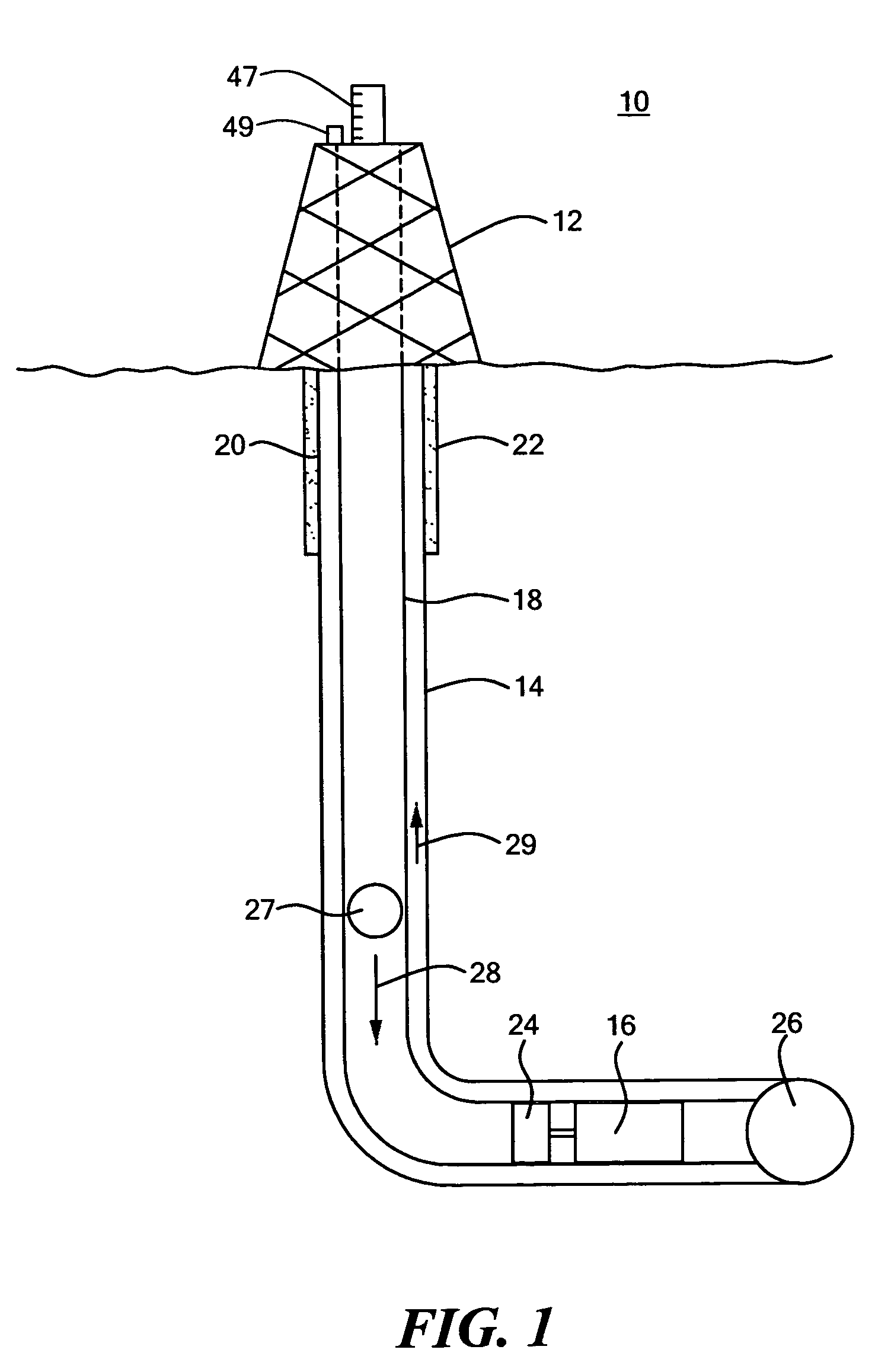
[0048]There is shown in FIG. 1 a drilling system 10 that includes drilling rig 12 in borehole 14, and borehole mitigated navigation system 16. Drilling rig 12 may be located on top of an ocean surface or on a land surface. Borehole 14 includes one or more connected drill pipes 18 that are surrounded by steel casing 20 and cement liner 22. Navigation system 16 includes DC power generator 24 and is adjacent to drill bit 26. While drilling, the mud flows to drive the drill bit, and also drives DC power generator 24. Mud 27 is flowed down the inside of the drill pipe in the direction of arrow 2...


PUM


Abstract

An omnidirectional borehole navigation system is provided that includes a housing that can be placed within the smaller diameter drill pipes used towards the bottom of a borehole, an outer gimbal connected to the housing, and at least two or more stacked inner gimbals that are nested in and connected to the outer gimbal, the inner gimbals each having an axis parallel to one another and perpendicular to the outer gimbal. The inner gimbals contain electronic circuits, gyros whose input axes span three dimensional space, and accelerometers whose input axes span three dimensional space. There are an outer gimbal drive system, an inner gimbal drive system for maintaining the gyro input axes and the accelerometer input axes as substantially orthogonal triads, and a processor responsive to the gyro circuits and the accelerometer circuits to determine the attitude and the position of the housing in the borehole.

Description

RELATED APPLICATION[0001]This application is a continuation-in-part of U.S. patent application Ser. No. 10 / 632,717, filed on Aug. 1, 2003 entitled “BOREHOLE NAVIGATION SYSTEM”, now issued as U.S. Pat. No. 6,895,678, issued on May 24, 2005, which is herein incorporated by reference.FIELD OF THE INVENTION[0002]This invention relates to a navigation system for traversing a borehole. More specifically, the invention relates to a borehole navigation system that can determine position and attitude for any orientation in a borehole utilizing multiple gimbals containing solid state or other gyros and accelerometers that fit within the small diameter of the borehole drill pipe.BACKGROUND OF THE INVENTION[0003]For several reasons, it is essential to accurately monitor and guide the direction of the drill bit such that a borehole is created where desired. One reason is that it is expensive to drill a borehole at a cost of about $500,000 per day. Another reason is that it may be necessary by la...

Claims


Application Information

Patent Timeline
Patent Type & Authority Patents(United States)
IPC IPC(8): G01C19/00G01C21/26
CPCE21B47/022
Inventor HANSBERRY, MITCHELL L.ASH, MICHAEL E.MARTORANA, RICHARD T.
Owner CHARLES STARK DRAPER LABORATORY
Why Eureka
Try Eureka