Hi-resolution three-dimensional imaging apparatus for topographic and 3d models

a three-dimensional imaging and topographic technology, applied in the direction of instruments, superimposed coating process, liquid/solution decomposition chemical coating, etc., can solve the problems of time-consuming and less accurate disadvantages, no technology provides the means for imaging content of similar resolution onto the surface of topographical, or other 3d models, and achieve accurate registration and scaling. , the effect of speed improvemen

Active Publication Date: 2007-11-06
SOLID TERRAIN MODELING
View PDF14 Cites 22 Cited by
  • Summary
  • Abstract
  • Description
  • Claims
  • Application Information

AI Technical Summary

Problems solved by technology

By contrast, two-dimensional map reading, or 2D topographical visualization, particularly by individuals who are not often exposed to such maps, can be much more challenging and is typically a skill that has to be learned and is developed over time.
However, none of these technologies provide the means for imaging content of similar resolutions onto the surface of topographical, or other 3D, models.
However the techniques used to render such surface features on 3D models while also indicating their relative positions have remained either coarse in implementation, or they have remained overly time-consuming or complicated when the image-content is hand-done.
Most approaches to date comprise various methods of topographical model making that is done by hand or has indicia or “terrain accessories” that are placed by hand on 3D models—and therefore are subject to human error particularly when the scale of the content is small and hi-resolution.
Each of these methods are very time-consuming and subject to human error.
. . ” and states that “These flexible accessories are realistically contoured models representing roads, streams, stream banks, earthworks, and walls, or segments thereof.” Brokaw's approach subject to human error, suggesting a time-consuming process where numerous ‘accessories’ would need to be added to maps, each of which would be subject to movement in position, raising questions as to the durability of this approach particularly for in-the-field applications.
Thus, none of the above-referenced prior art incorporates the accurate topographic method and repeatability of a computer-imaging system comprising apparatus for imaging hi-resolution content onto the surfaces of terrain models, and other 3D models, and for rendering accurately registered indicia onto the surfaces of such models.

Method used


Image

  • Hi-resolution three-dimensional imaging apparatus for topographic and 3d models
  • Hi-resolution three-dimensional imaging apparatus for topographic and 3d models
  • Hi-resolution three-dimensional imaging apparatus for topographic and 3d models

Examples


Embodiment Construction

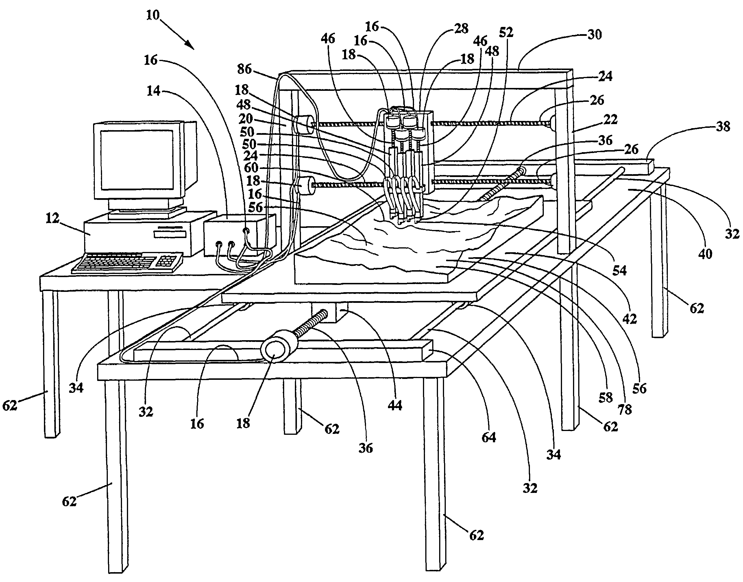
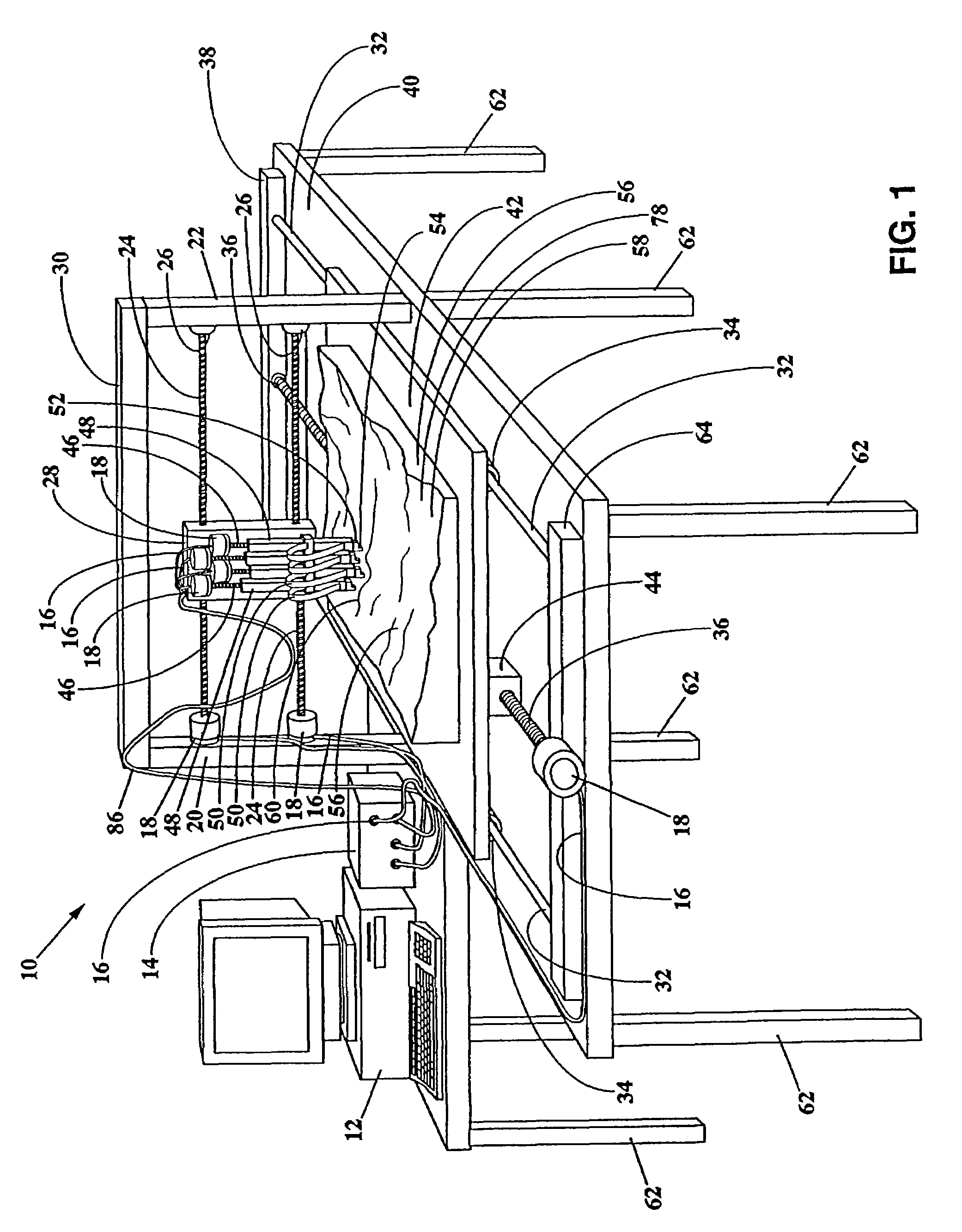
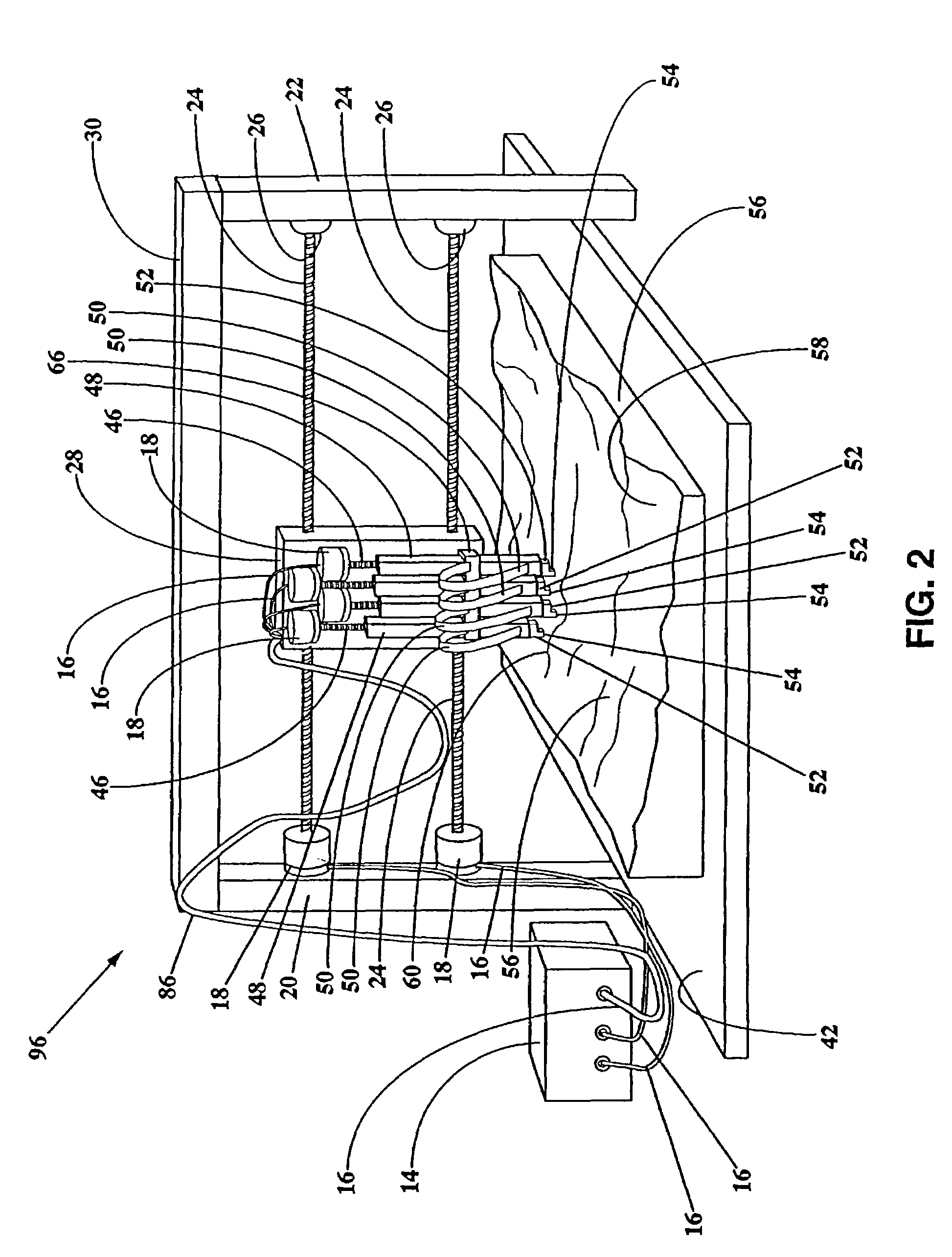
[0029]With reference to FIG. 1, a hi-resolution 3D printing apparatus 10 for imaging content onto topographical, and other 3D, models, is shown adjacent to, and is electronically coupled with, a computer system 12. The computer has a central processor that executes instructions, a memory for storing instructions to be executed, and non-volatile storage for storing the messages. Also included is a control interface 14 having electronic coupling 16 to control a plurality of stepper motors 18. It is noted that although interface 14 is shown in a housing which is external to the computer and separate from the stepper motors, one or more of the apparatus-controlling components housed therein could instead be located within the housing of the computer (e.g., on a circuit board interfaced with the CPU of the computer), and / or could be located within, or adjacent to, one or more stepper motor housings. Adjacent to computer 12 and interface 14 is a Y-axis support bed 40 that is supported by ...


PUM

PropertyMeasurementUnit
surface featuresaaaaaaaaaa
elevationaaaaaaaaaa
coloraaaaaaaaaa

Abstract

The present invention is directed to an automated system that includes a hi-resolution three-dimensional imaging apparatus for topographic modeling that is electronically coupled with a computer. The system incorporates one or more algorithms for converting the complex and randomly-occurring contours found in natural terrain into an efficient series of adjacent and parallel coloring-agent imaging paths or swaths (comprised of inks, dyes, paints, and / or pigments). The swaths are defined in simplified 2-axis surface contour-following printer-head movements by the system's CPU, printer driver software, driver circuitry and / or logic circuitry. This multi-axis control of the system assures that each of the swaths are seamlessly rendered next to one another while also maintaining an optimal proximity between the upper surface of the 3D model and the nozzle end of one or more hi-resolution printer. A single coloring-agent such as black ink, may be used solely, or in combination with a plurality of colors such as a Cyan, Magenta, Yellow and Black or “CMYK” combination. The system also incorporates algorithms for applying accurately registered indicia of a prescribed color, or colors, onto the surface of models including man-made boundaries such as property lines, easements, right-of-ways, land-development features; naturally occurring boundaries such as ridges and flow-lines, bodies of water, lakes, lake-beds, rivers, river-beds and forested areas including tree varieties; lettering including the accommodation of a variety of fonts; graphical embellishments; and cartographic elements.

Description

[0001]This application claims the benefit of U.S. Provisional Patent application Ser. No. 60 / 195,129 filed on Apr. 6, 2000, the entire disclosures of which are incorporated herein by reference.BACKGROUND OF THE INVENTION[0002]1. Field of the Invention[0003]The present invention generally relates to apparatus, methods and systems for printing in hi-resolution onto the surface of topographic and three-dimensional models, and more specifically, it pertains to apparatus for accurately and durably rendering topographic, photographic and / or cartographic content onto the surface of three-dimensional (3D) terrain models generally, or for making such models quickly when needed in emergency situations, or for adding accurately and durably registered indicia to any in a variety of types of topographical models.[0004]2. Description of Related Arts[0005]Three-dimensional topography, and the cartography related thereto, have been useful media in assisting in the visualization of features pertaini...

Claims


Application Information

Patent Timeline
Patent Type & Authority Patents(United States)
IPC IPC(8): B05B13/04G06T17/05G09B25/06
CPCG09B25/06G06T17/05
Inventor FAULKNER, LAWRENCE Q.FISHER, MARK E.LUTON, JUSTIN
Owner SOLID TERRAIN MODELING
Why Eureka
Try Eureka