
System and method for providing routing, mapping, and relative position information to users of a communication network

a communication network and user technology, applied in the field of location and navigational systems and the determination of local and remote position information, can solve the problems of inability to implement cross-referencing of telephone numbers to addresses locally, information that is out of date and inaccurate, and systems that do not have storage capacity, etc., to achieve the effect of low processing capacity, limited resources, and small display area

Inactive Publication Date: 2008-02-19
ARTAX LLC
View PDF27 Cites 207 Cited by
  • Summary
  • Abstract
  • Description
  • Claims
  • Application Information

AI Technical Summary

Benefits of technology

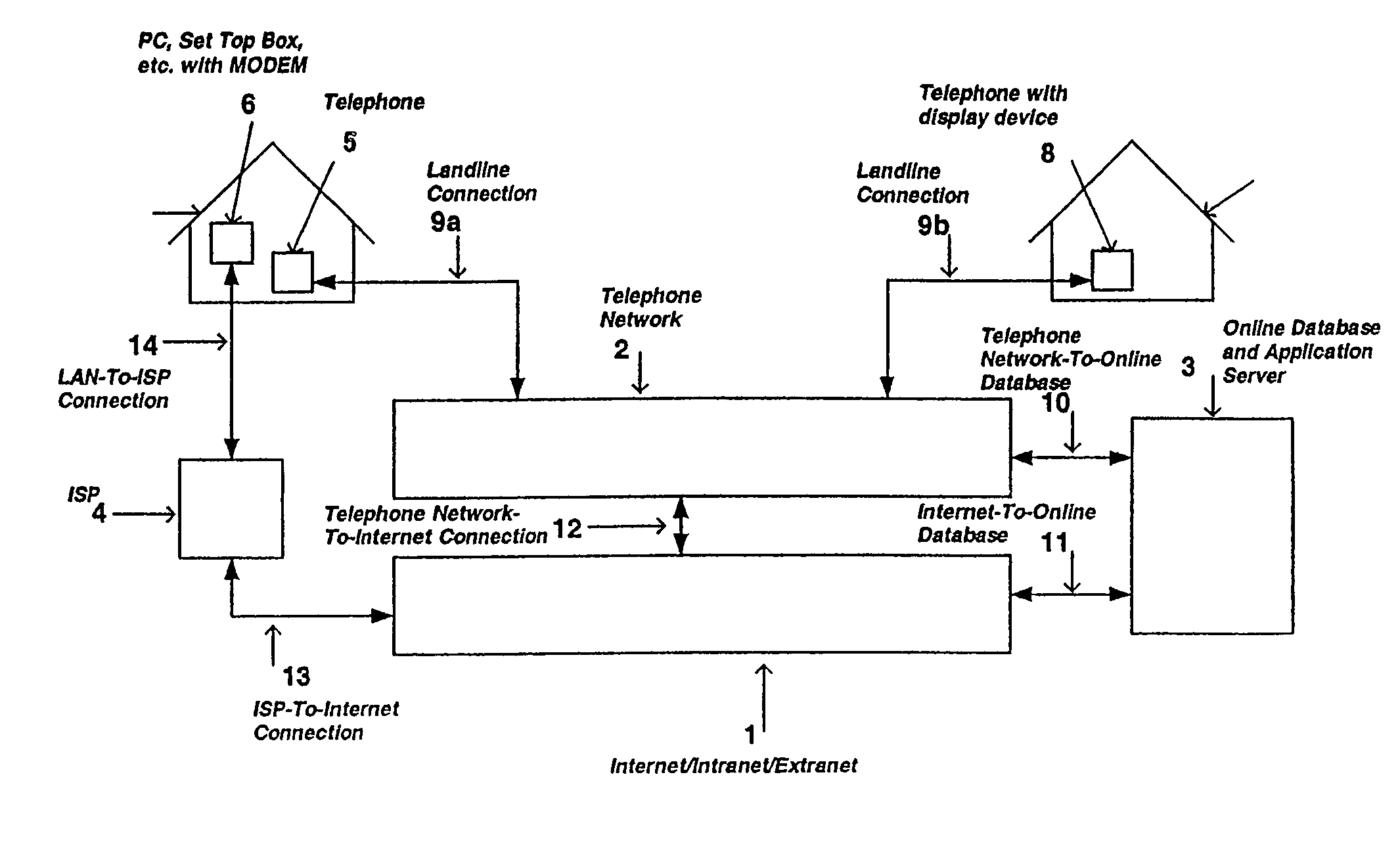
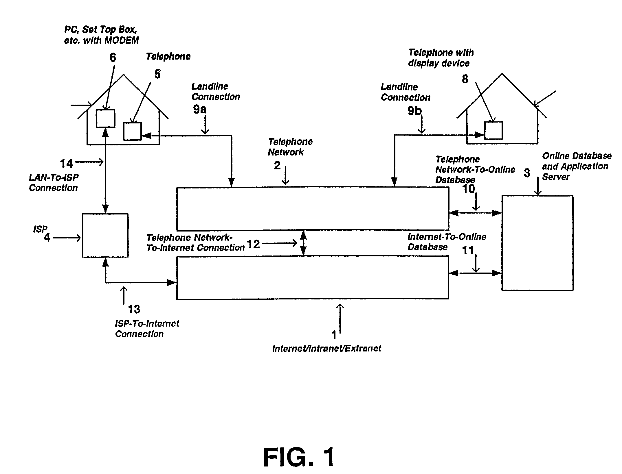
[0020]In accordance with one embodiment of the present invention, for a landline-to-landline application, such as a call made between two standard telephones, a user can dial a telephone number to a remote device. The act of dialing the telephone number to another remote landline telephone, such as a residential telephone, triggers the transfer of position information, such as in the form of a map, to either one or both of the local and / or remote telephone devices. If the local and / or remote telephone devices do not incorporate a display unit, the position information can be routed to an adjacent computing and / or display device, such as a personal computer or cable television's set top box, that is connected to a network, such as a telephone or wireless network or the Internet. In this case, users who are initiating or receiving the telephone calls have their local telephone numbers stored into a database that resides on a secure network. Once the user has logged on to the personal computer via authentication and authorization procedures, any call that originates or is destined to their telephone number can identify the position of the other landline telephone number, based on predetermined privacy settings associated with the other landline telephone number. Alternatively, the user placing the call can obtain similar information about the destination telephone number.
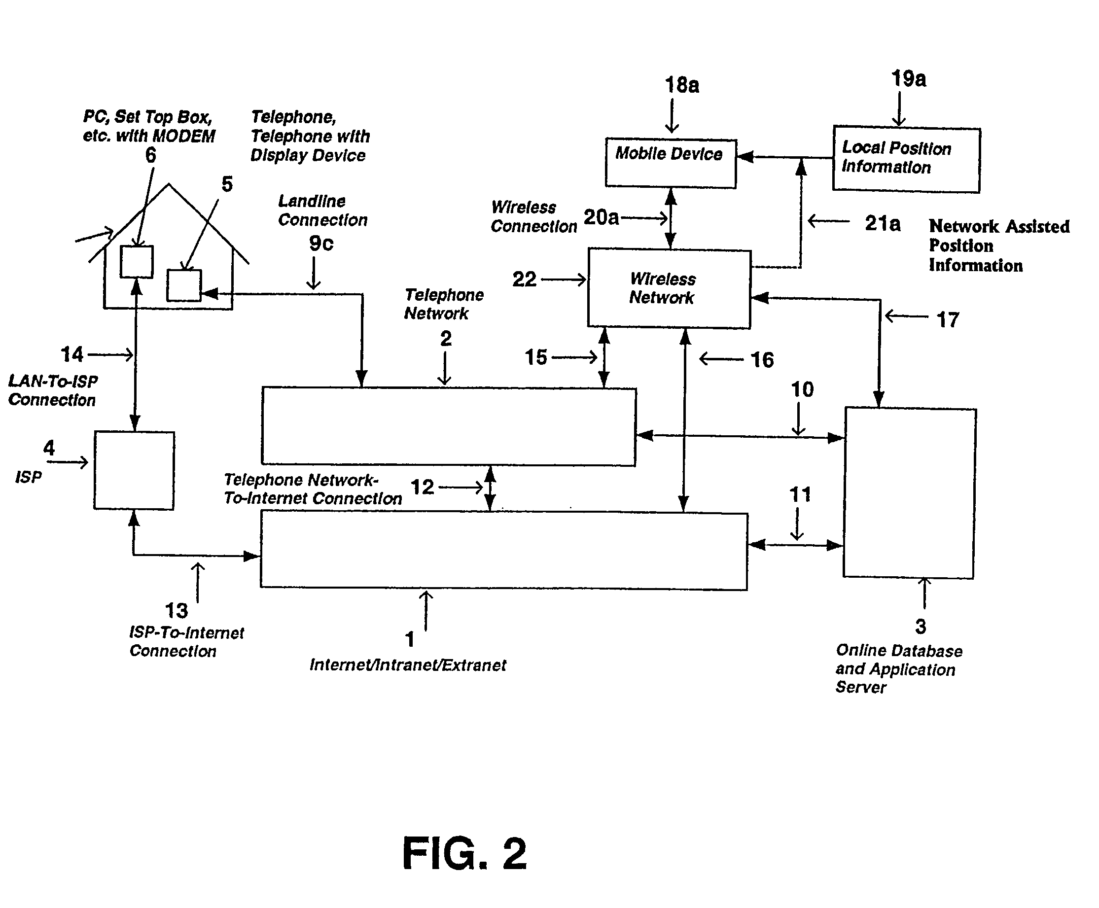
[0024]Wireless and / or landline devices are not always suited to post-process the local and remote position information obtained from some of the methods previously described. In one embodiment, a wireless telephone that obtains both local and remote position information can pass the obtained position information to another device which can better process and / or display the data. This is applicable to current wireless phones that have limited resources, such as a small display area, low processing capability, limited memory, and short battery duration, in contrast to an in-vehicle navigation system that typically has an abundance of these resources. It is therefore advantageous and convenient, since most in-vehicle navigation system do not posses wireless capability, for the wireless telephone to pass the remote and / or the local, position information to the in-vehicle navigation system for processing and display of the route and map information. In this embodiment, the connection between the wireless telephone and in-vehicle navigation system can be established via a wireless connection, such as a Bluetooth connection, an infrared connection, or a wired connection such as a serial or USB cable.

Problems solved by technology

As an additional drawback, some navigation systems that do not have the storage capability, such as wireless PDAs (Personal Digital Assistant) or typical cell phones, are not able to implement cross referencing of telephone numbers to addresses locally due to the large memory and storage size requirements of such an operation and low computational power of the devices.
Furthermore, since most businesses and individuals can change their telephone numbers numerous times while at their current address determining destination locations from telephone numbers on a locally-stored database inherently causes the information to be out of date and inaccurate.
These and other changes, such as a new telephone line or an area code change, would invalidate the current version of locally-stored DVD or CD-ROM disc information.
As a further drawback, mobile navigation devices and stationary landline computing devices are not always associated with telephone numbers, but rather Internet Protocol (IP) addresses or the like.
Convention art systems are typically incapable of obtaining position information over dynamically-configured connections such as, for example, current fleet tracking systems that require predefined user and / or device configurations before the transfer of position information is possible.

Method used


Image

  • System and method for providing routing, mapping, and relative position information to users of a communication network
  • System and method for providing routing, mapping, and relative position information to users of a communication network
  • System and method for providing routing, mapping, and relative position information to users of a communication network

Examples


Embodiment Construction

[0035]The various embodiments of the present invention will be described with reference to FIGS. 1-9. In the landline-to-landline example, as illustrated in FIGS. 1-9, a user places a telephone call from a standard telephone 5 and 54 to a destination telephone, such as another landline telephone 8 and 55. The landline standard telephones are typically connected to the telephone network 2 through a dedicated landline connection 9a and 9b. The telephone number that is dialed is known to the telephone network 2. When a standard telephone 5 and 54 is used to place a telephone call the telephone network 2 updates the online database and application server (ODAS) 3 with the originating and destination telephone numbers. In one embodiment this is typically done using a signaling system 7 (SS7) architecture via a connection 10 to the ODAS 3. The destination telephone 8 and 55 has an extended form of Caller-ID, such as consisting of a display, a processing unit, and a MODEM. This extended fo...


PUM


Abstract

The present invention is directed to a system and method for providing real-time position information of one party to another party by utilizing a conventional telecommunication network system such as the convention telephone network, a mobile telecommunications network, a computer network, or the Internet. More specifically, the preferred embodiments of the present invention allow a caller and a receiver of a telephone call to provide to and receive from each other position information related to the caller and / or receiver's physical location, including address information, GPS coordinates, nearby fixed locations such as a parking structure, etc. Additionally, the preferred embodiments of the present invention allow a caller and receiver to retrieve routing instructions or maps for traveling to or from each other. In another embodiment of the present invention, a party may locate the position of another party via the entry of the other party's unique identifier such as a phone number of the other party's mobile phone. In yet another embodiment of the present invention, the position information of a party may be concurrently delivered to another party's computer terminal whereby the other party can process the information in further detail.

Description

CROSS-REFERENCE TO RELATED APPLICATIONS[0001]Embodiments of the present invention claim priority from U.S. provisional patent application Ser. No. 60 / 305,975 filed Jul. 17, 2001.BACKGROUND OF THE INVENTION[0002]1. Field of Invention[0003]This invention relates to location and navigational systems and to the determination of local and remote position information in ad-hoc landline and wireless systems, including the utilization of unique identification addresses, such as telephone numbers or Internet Protocol (IP) addresses, for such purposes as providing real-time location information, maps, routing, and direction finding.[0004]2. Description of the Related Art[0005]Navigational systems, defined as systems that provide a unit's local position and a way of planning a course around the unit's local position, sometimes to a remote position, such as in-vehicle navigations systems do, are well know in the art. Typically, an in-vehicle navigation system consists of a display screen, proce...

Claims


Application Information

Patent Timeline
Patent Type & Authority Patents(United States)
IPC IPC(8): H04Q7/20G01C21/26H04M1/57H04M1/725H04M3/42
CPCG01C21/26H04M3/42H04M1/575H04M3/42042H04M3/42093H04M3/42348H04M2242/22H04M2250/10
Inventor SHEHA, MICHAEL A.PETILLI, STEPHENSHEHA, ANGIE
Owner ARTAX LLC
Learn More