Mapping program including a map, process and system for precisely representing or determining a location on the map and an electronic device and a storage medium therefor

a mapping program and map technology, applied in the field of precisely determining a position on a map, can solve the problems of difficult to remember a particular location, and no way in which individuals or businesses could easily specify the location of their residence, and achieve the effect of more usable forma

Inactive Publication Date: 2008-06-03
BOWLING SHANNON
View PDF5 Cites 2 Cited by
  • Summary
  • Abstract
  • Description
  • Claims
  • Application Information

AI Technical Summary

Benefits of technology

[0013]It is another object of the invention is to provide a method that offers intuitive information about a location. This method may provide points of interest with a set of characters to easily represent location that have no addresses.
[0014]It is still another object of the invention to provide a more practical method and system for representing a location in a more usable format that the current coordinate system. A character code may be entered into a handheld device with relative ease requiring only eight digits to represent any location in the continental United States. This overcomes the present dilemma of requiring as many as twenty to forty digits to define a particular address.

Problems solved by technology

One problem associated with using latitude and longitude coordinates to represent a location is the difficult nature of easily remembering a particular location when it does not correspond to an absolute elevation angle and particular meridian.
Until now, there were no ways in which individuals or business could easily specify the location of their residences without the use of a cumbersome coordinate code or address.

Method used


Image

  • Mapping program including a map, process and system for precisely representing or determining a location on the map and an electronic device and a storage medium therefor
  • Mapping program including a map, process and system for precisely representing or determining a location on the map and an electronic device and a storage medium therefor
  • Mapping program including a map, process and system for precisely representing or determining a location on the map and an electronic device and a storage medium therefor

Examples


Embodiment Construction

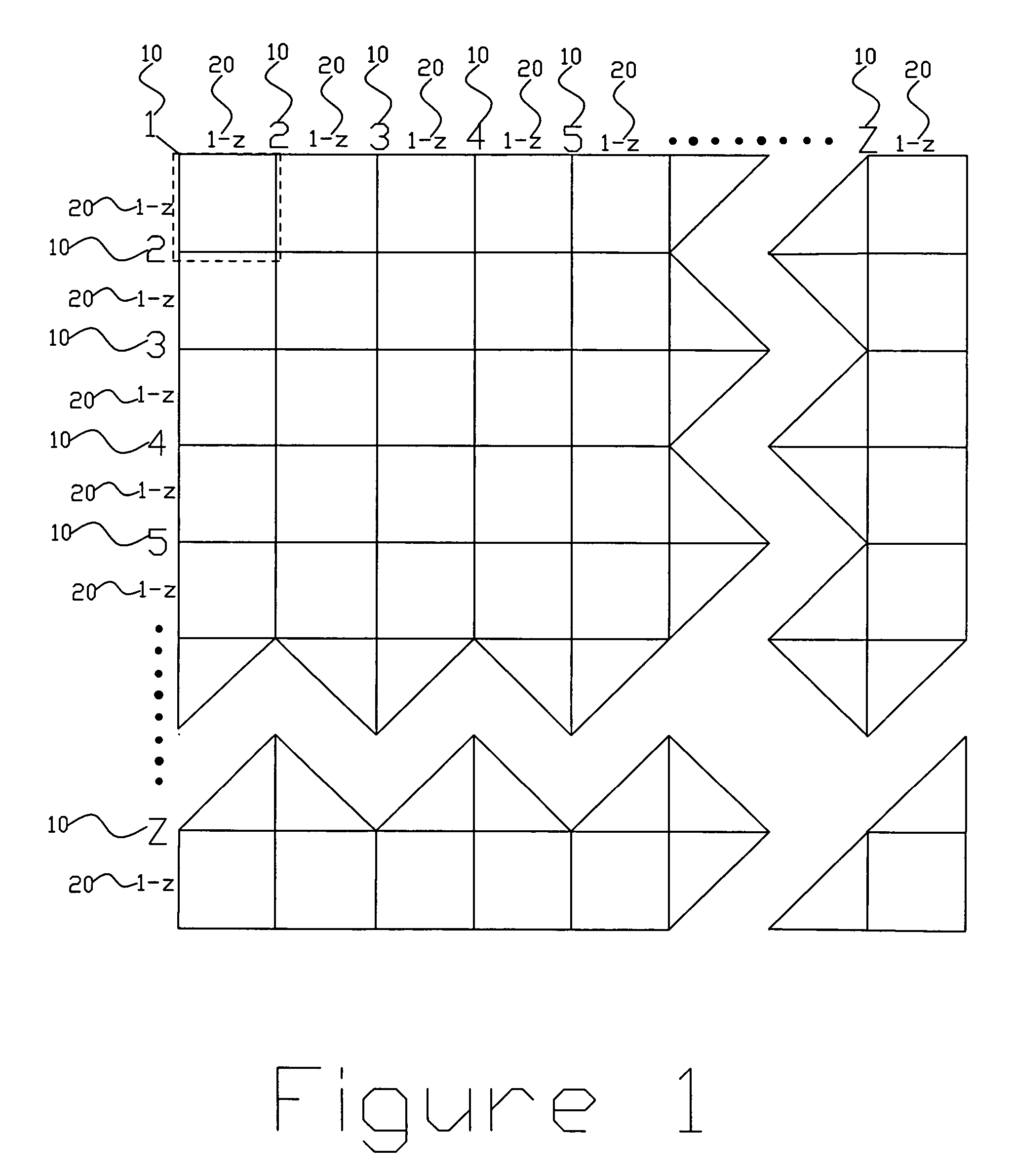
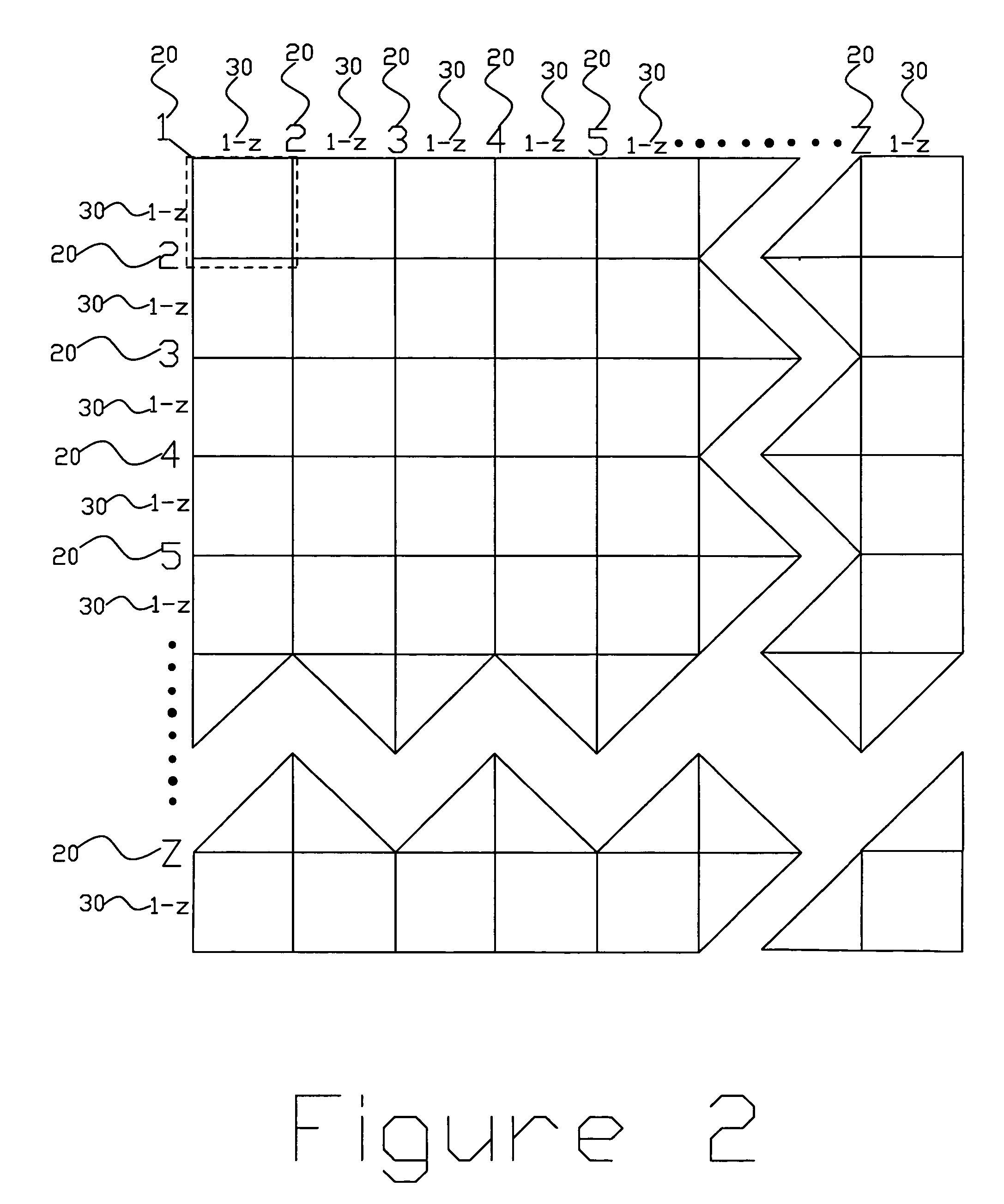
[0026]FIGS. 1 through 3 depict grids for overlaying a map to define a point. The present invention includes a base number of 35. This is created by using the numbers 1-9 and the letters A-Z. Thus, 1-Z corresponds to 35 individual characters. A 35×35 line grid may be constructed in this manner. Each individual grid defined by two horizontal and two vertical lines may be further broken down by adding a second set of characters relating to 1-Z. This process can be continued until an infinite number of smaller grids are created. Thus, the base number of 35 is raised to an exponential value each time another set of characters are added.

[0027]In FIG. 1, characters 10A and 10B relate to a first number of each set of characters defining a point. Characters 20A and 20B, as shown in FIG. 1, relate to the second number in each set of characters. When written in the following coordinates format {XX; XX}, as shown in FIG. 5B, the first set of characters relate to latitude and the second set of c...


PUM


Abstract

A mapping program includes an overlay grid of intersecting lines represented by two series of numbers. An origin is defined and an area of interest is defined. The origin corresponds to a location on a map. One series of numbers relates to longitude; while the other series of numbers relates to latitude. Each series of numbers are represented by two or more digits. Each digit represents up to 35 different numerals or letters. When two digits are used to represent a location, the combined number of lines for each series of number may comprise up to 1225 lines. Thus, the total number of lines represented by each series of number corresponds to a power of the base number of possibilities up to 35; the power being represented by the number of digits used in each series of numbers. These numbers are overlaid onto a map having points corresponding to actual longitudinal and latitudinal locations. A device for converting between the latitude and longitude is provided. A storage medium is also provided for storing a series of steps to perform the operations.

Description

[0001]The present application claims priority from U.S. Provisional Patent Application Ser. No. 60 / 650,275 filed on Feb. 4, 2005 and claims priority therefrom.[0002]This application did not receive federal research and development funding.BACKGROUND OF THE INVENTION[0003]The present invention relates to systems, devices and methods for precisely determining a position on a map. More specifically, the present invention relates to a novel method and apparatus for determining a position with a new coordinate system. Characters represented by letters and numbers are used to reduce the quantity of numbers ordinarily necessary for representing a position on a map.[0004]Any location on earth may be described by two sets of characters that represent coordinates on a map. Latitude and longitude are currently used for representing positions on a map. Both latitude and longitude are angles measured in degrees, minutes of arc and seconds of arc. To specify the latitude of a point on the surface...

Claims


Application Information

Patent Timeline
Patent Type & Authority Patents(United States)
IPC IPC(8): G08G1/123
CPCG09B29/007
Inventor BOWLING, SHANNON
Owner BOWLING SHANNON
Why Eureka
Try Eureka