Methods and systems for enhancing accuracy of terrain aided navigation systems

a technology of terrain aided navigation and methods, applied in the field of air vehicle navigation, can solve the problem of low accuracy update of ptan over featureless terrain

Active Publication Date: 2008-08-05
HONEYWELL INT INC
View PDF20 Cites 6 Cited by
  • Summary
  • Abstract
  • Description
  • Claims
  • Application Information

AI Technical Summary

Problems solved by technology

For example, PTAN provides a very low accuracy update over featureless terrain such as water, or flat desert since it is difficult to correlate the featureless terrain with the data stored in the DEM.

Method used


Image

  • Methods and systems for enhancing accuracy of terrain aided navigation systems
  • Methods and systems for enhancing accuracy of terrain aided navigation systems
  • Methods and systems for enhancing accuracy of terrain aided navigation systems

Examples


Embodiment Construction

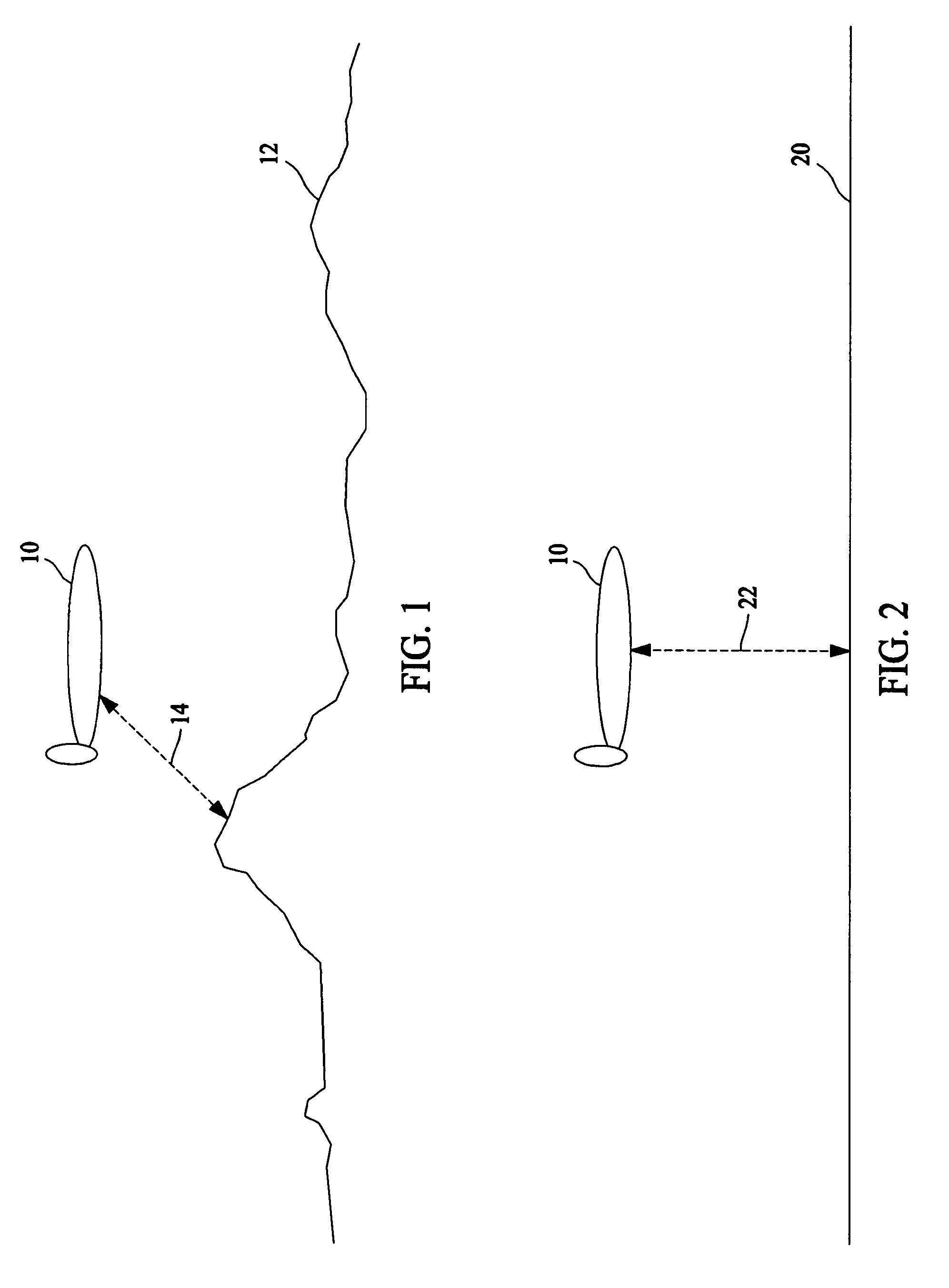
[0015]FIG. 1 illustrates an aircraft 10 flying over a terrain 12 with abundant features. A radar altimeter (not shown) within aircraft 10 transmits a beam 14 towards terrain 12 and receives the reflected beam 14 for processing. The widely varying features of terrain 12 allow for easy correlation of the altitudes provided by the radar altimeter with a digital elevation map (not shown). Correlation of the altitudes provided by the radar altimeter with the digital elevation map provide a mechanism for determining a location of aircraft 10 with respect to the digital elevation map.

[0016]FIG. 2 illustrates aircraft 10 flying over a featureless terrain 20. Examples of featureless terrains similar to terrain 20 include bodies of water or a flat plain or desert. Again, the radar altimeter (not shown) within aircraft 10 transmits a beam 22 towards terrain 20 and receives the reflected beam 22 for processing. The non-varying features of terrain 20 make it difficult to correlate the altitudes ...


PUM


Abstract

A navigation system is described which includes a navigation processor, an inertial navigation unit configured to provide a position solution to the navigation processor, and a digital elevation map. The described navigation system also includes a radar altimeter having a terrain correlation processor configured to receive map data from the digital elevation map and provide a position solution based on radar return data to the navigation processor. A map quality processor within the navigation system is configured to receive map data from the digital elevation map and provide a map quality factor to the navigation processor which weights the position solution from the terrain correlation processor according to the map quality factor and determines a position solution from the weighted terrain correlation processor position solution and the position solution from the inertial navigation unit.

Description

BACKGROUND OF THE INVENTION[0001]This invention relates generally to navigation of air vehicles, and more specifically, to methods and systems for enhancing accuracy of terrain aided navigation systems.[0002]Precision terrain aided navigation (PTAN) correlates interferometric Doppler radar ground return data with a digital elevation map (DEM), resulting in position updates that are provided to a navigation system. Typical navigation systems incorporate at least two sources of navigation data to provide a total position solution. For example, position data from an inertial navigation system (INS), can be combined with position data from PTAN to provide a total position solution. The radar updates from PTAN are utilized to subtract out drift errors that occur within inertial sensor systems like the INS.[0003]Accuracy of the PTAN system relies somewhat on the type of terrain features over which the aircraft is flying. For example, PTAN provides a very low accuracy update over featurele...

Claims


Application Information

Patent Timeline
Patent Type & Authority Patents(United States)
IPC IPC(8): G01C21/00G01C21/26G01S13/00G01S13/86G01S13/88G06F19/00
CPCG01C21/005G01S13/882G01S13/86
Inventor HAGER, JAMES R.ALMSTED, LARRY D.
Owner HONEYWELL INT INC
Why Eureka
Try Eureka