Satellite based vehicle guidance control in straight and contour modes

a satellite-based vehicle and guidance control technology, applied in the direction of distance measurement, navigation instruments, instruments, etc., can solve the problems of slow field operation, poor driving training of operators, and high crop yield

Active Publication Date: 2008-10-14
AGJUNCTION INC
View PDF16 Cites 122 Cited by
  • Summary
  • Abstract
  • Description
  • Claims
  • Application Information

AI Technical Summary

Problems solved by technology

These techniques strive to minimize overlapping of rows and gaps between rows and reduce damage to crops by physical contact, and thereby result in higher crop yield, faster field operations and decreased costs to the farmer.
These have been used for automatic steering of a main vehicle e.g., tractor and are often used on large farms where high value crops are grown and operators are not well trained in driving.
Unfortunately, most inertial and gyro based systems are expensive and large.
Existing auto steer guidance methods solve the positioning of the vehicle in straight-line guidance mode, but do not necessarily address the positioning of the implement.
As farming becomes increasingly mechanized and farm implements faster and larger so too does the difficulty of accurate positioning.

Method used


Image

  • Satellite based vehicle guidance control in straight and contour modes
  • Satellite based vehicle guidance control in straight and contour modes
  • Satellite based vehicle guidance control in straight and contour modes

Examples


Embodiment Construction

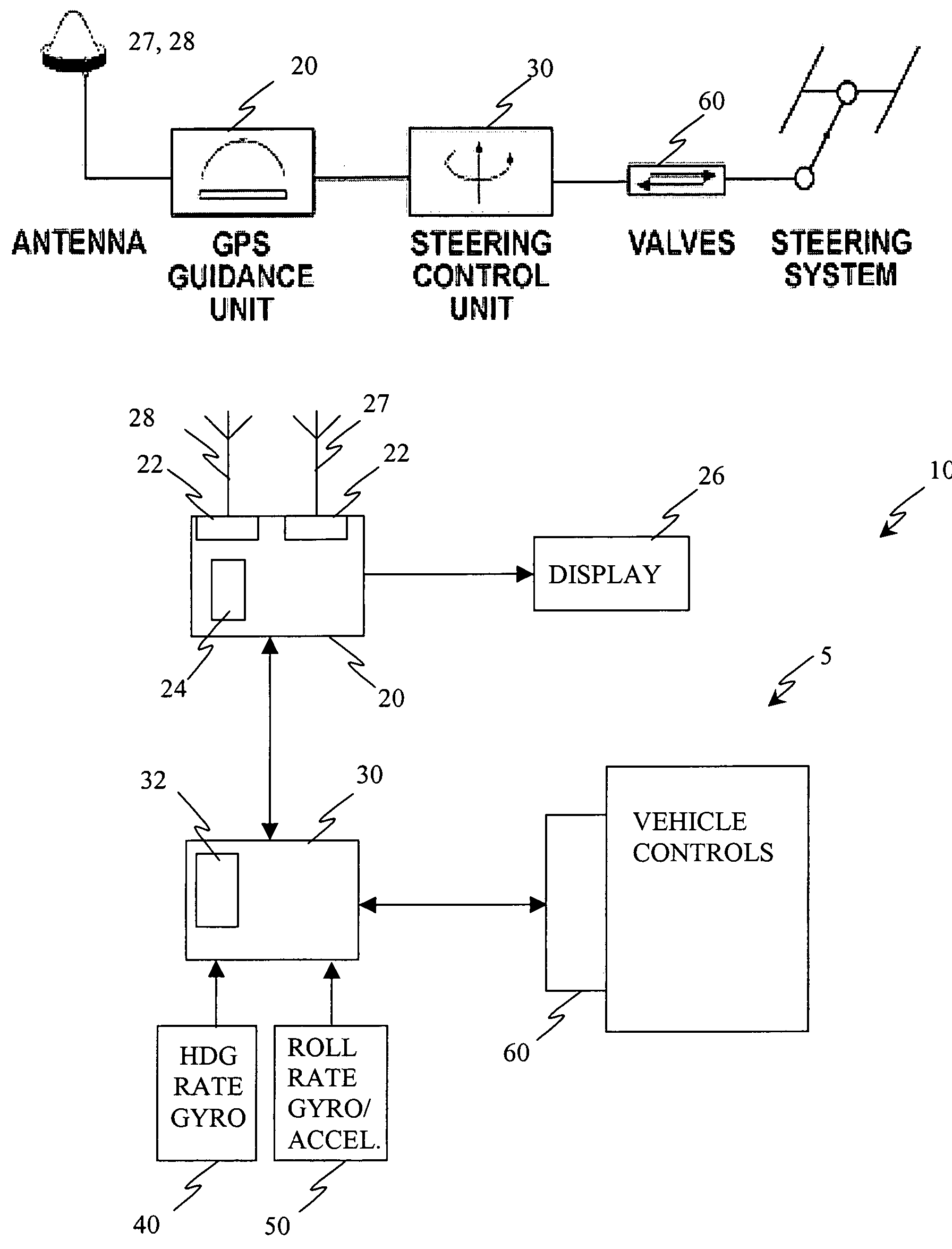
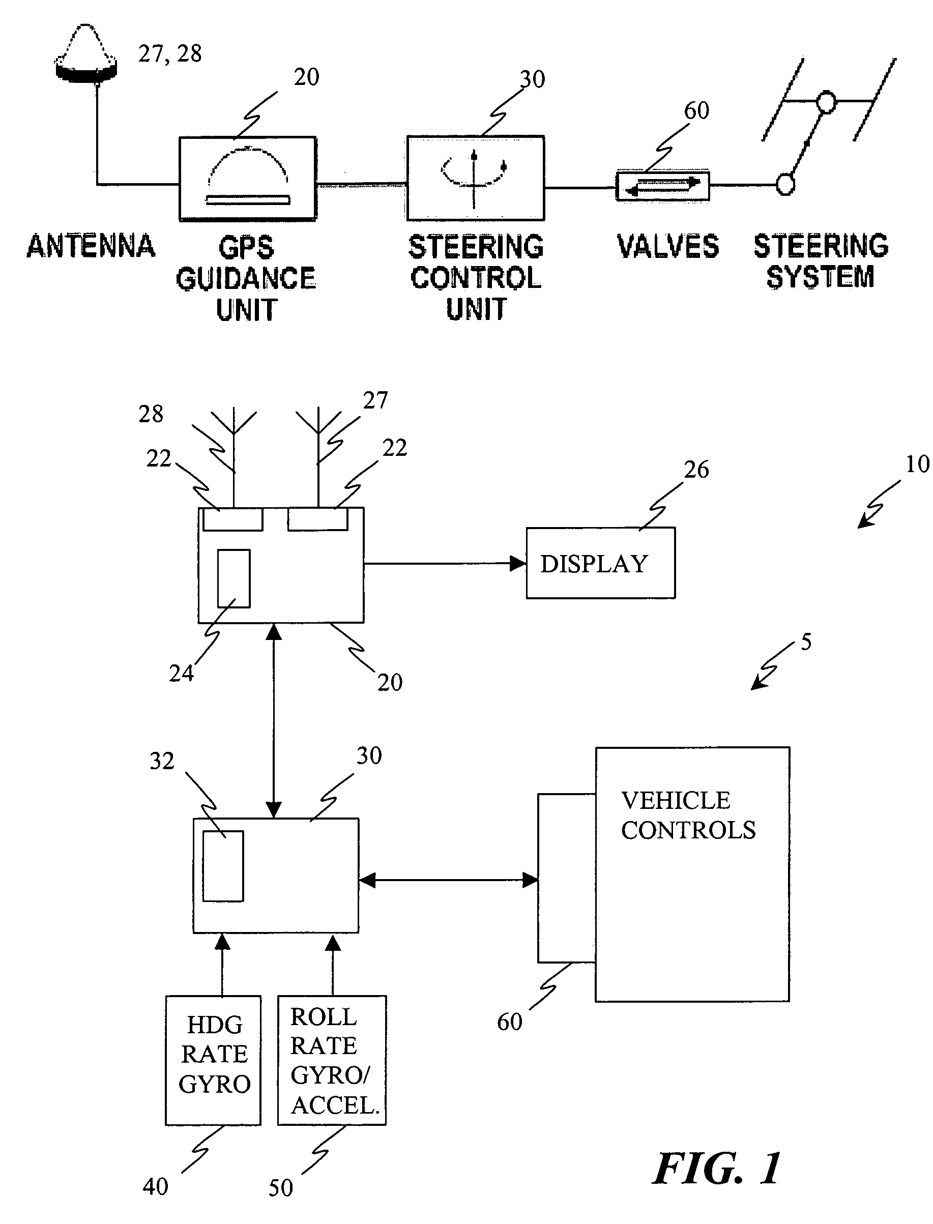
[0022]Referring to FIG. 1, an exemplary embodiment of a guidance system 10 for a vehicle 5 includes, but is not limited to, two primary components: a DGPS guidance unit 20 and a steering control unit (SCU) 30. In the DGPS guidance unit 20, a DGPS receiver 22 is connected to a controller e.g., processor 24, which generates a graphical and numerical display 26 for an operator and processes the control signal guidance algorithms. This controller 24 communicates with a controller 32 in the steering control unit 30 to direct the vehicle 5. It will be appreciated that the guidance unit 20 may include additional elements such as the antennae 27 and 28 for GPS and GPS differential corrections and other interfaces.

[0023]The steering control unit 30 includes a controller 32 that interfaces with a heading rate gyro 40 and cross aligned accelerometer and roll rate gyro 50 and generates steering control signals for hydraulically or electrically controlled steering mechanisms of the vehicle. The ...


PUM


Abstract

A method for steering an agricultural vehicle comprising: receiving global positioning system (GPS) data including position and velocity information corresponding to at least one of a position, velocity, and course of the vehicle; receiving a yaw rate signal; and computing a compensated heading, the compensated heading comprising a blend of the yaw rate signal with heading information based on the GPS data. For each desired swath comprising a plurality of desired positions and desired headings, the method also comprises: computing an actual track and a cross track error from the desired swath based on the compensated heading and the position; calculating a desired radius of curvature to arrive at the desired track with a desired heading; and generating a steering command based on the desired radius of curvature to a steering mechanism, the steering mechanism configured to direct the vehicle.

Description

CROSS-REFERENCE TO RELATED APPLICATIONS[0001]This application claims the benefits of U.S. Provisional Application No. 60 / 456,130, filed Mar. 20, 2003 the contents of which are incorporated by reference herein in their entirety, and is a continuation-in-part of U.S. patent application Ser. No. 10 / 396,788 filed on Mar. 25, 2003, now U.S. Pat. No. 6,711,501, issued Mar. 23, 2004, which is a continuation-in-part of U.S. patent application Ser. No. 09 / 733,641 filed on Dec. 8, 2000, now U.S. Pat No. 6,539,303, issued Mar. 25, 2003.BACKGROUND[0002]The invention relates to the use of satellite systems to control the guidance of vehicles and the positioning of towed implements. More particularly, steering control of agricultural, mining, and construction vehicles. For example, there is a need to accurately position agricultural vehicles and their implements (generally towed) used for plowing, listing, planting of crops, mechanically cultivating around crops and applying chemicals on and arou...

Claims


Application Information

Patent Timeline
Patent Type & Authority Patents(United States)
IPC IPC(8): G06F7/70A01B69/04G05D1/02G06F19/00
CPCA01B69/008G05D1/027G05D1/0278G05D2201/0201
Inventor MCCLURE, JOHN A.COLLINS, DENNIS M.TIMM, JOHN T. E.
Owner AGJUNCTION INC
Why Eureka
Try Eureka