
Systems and methods with integrated triangulation positioning and dead reckoning capabilities

a technology of dead reckoning and triangulation, applied in the field of navigation devices, can solve the problems of pdas, plug-in gps receiver modules and pdas, and large memory capacity, and achieve the effects of reducing the cost of pdas, and improving the accuracy of pdas

Inactive Publication Date: 2009-01-27
GARMIN
View PDF58 Cites 37 Cited by
  • Summary
  • Abstract
  • Description
  • Claims
  • Application Information

AI Technical Summary

Benefits of technology

The present invention provides a solution for the problems of navigational systems by providing complementary, mobile navigation devices that incorporate triangulation positioning and dead reckoning positioning components. This allows for reliable navigation in urban-canyons or when the primary positioning service is interrupted. The navigation method involves using the dead reckoning components to determine the position when the triangulation positioning is degraded. Overall, the invention improves the accuracy and reliability of navigation systems.

Problems solved by technology

Such processor and memory capability can be extensive since the cost of high end vehicles covers the added equipment.
However, such vehicles are often out of the price range for the average consumer.
There are problems associated with various plug-in GPS receiver modules and PDAs.
One problem is that a PDA with a plug-in GPS receiver module is cumbersome to handle and use.
Additionally, the plug-in GPS receiver module and the PDA do not function together to provide integrated PDA features.
Further, among portable electronic navigation devices, including PDAs with plug-in receiver modules, there does not exist a back-up mechanism for continuing navigation related services when positioning signal reception is lost.
This is particular problematic when such devices are used in “urban-canyons” such as street level in a city beneath towering sky scrapers which “shade” or block satellite reception.
Additionally, there are numerous other reasons which may cause a navigation device using a triangulation positioning technology to lose reception of positioning signals.

Method used


Image

  • Systems and methods with integrated triangulation positioning and dead reckoning capabilities
  • Systems and methods with integrated triangulation positioning and dead reckoning capabilities
  • Systems and methods with integrated triangulation positioning and dead reckoning capabilities

Examples


Embodiment Construction

[0025]In the following detailed description of the invention, reference is made to the accompanying drawings which form a part hereof, and in which is shown, by way of illustration, specific embodiments in which the invention may be practiced. The embodiments are intended to describe aspects of the invention in sufficient detail to enable those skilled in the art to practice the invention. Other embodiments may be utilized and changes may be made without departing from the scope of the present invention. The following detailed description is, therefore, not to be taken in a limiting sense, and the scope of the present invention is defined only by the appended claims, along with the full scope of equivalents to which such claims are entitled.

[0026]The present invention is drawn to, among other things, systems and methods for complementary, mobile navigation devices which incorporate triangulation positioning functionality and one or more dead reckoning positioning components, e.g. to...


PUM


Abstract

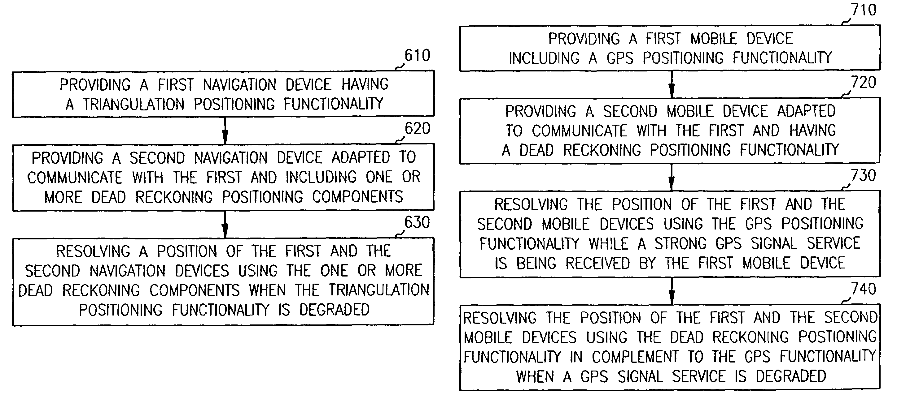
Systems and methods are provided for complementary navigation devices with various integrated positioning functionality. The navigation method includes providing a first navigation device. The first navigation device includes a triangulation positioning functionality. The method includes providing a second navigation device adapted to communicate with the first navigation device. The second navigation device includes one or more dead reckoning positioning components. The method further includes resolving a position of the first and the second navigation devices. Resolving the position includes using the one or more dead reckoning positioning components in complement to the triangulation positioning functionality to determine the position when the triangulation positioning functionality is degraded.

Description

[0001]This application is a Continuation of U.S. application Ser. No. 10 / 184,373, filed Jun. 28, 2002 now U.S. Pat. No. 6,801,855, the specification of which is incorporated herein by reference.CROSS REFERENCE TO RELATED APPLICATIONS[0002]This application is related to the following co-pending, commonly assigned U.S. patent application “Portable Navigation Device with Integrated GPS and Dead Reckoning Functionality”, Ser. No. 10 / 184,844, “Rugged, Waterproof, Navigation Device with Touch Panel”, Ser. No. 10 / 186,155, and “Rugged, Waterproof, Navigation Device with Touch Panel”, Ser. No. 10 / 185,604, which are herein incorporated by reference.FIELD OF THE INVENTION[0003]The present invention relates generally to navigation devices and, more particularly, to systems and methods with integrated Global Positioning System (GPS) and dead reckoning capabilities.BACKGROUND OF THE INVENTION[0004]Electronic navigation devices employing Global Positioning System (“GPS”) receivers are known. The G...

Claims


Application Information

Patent Timeline
Patent Type & Authority Patents(United States)
IPC IPC(8): G01C21/00G01S5/14G01S19/48H04B7/185
CPCG01C21/165G01S19/49G01S5/011G01C21/1654
Inventor WALTERS, THOMAS H.PEMBLE, CLIFF A.KAO, MIN H.
Owner GARMIN
Learn More