Automatic asset detection, location measurement and recognition

a technology of automatic asset detection and location measurement, applied in the field of automatic asset management system, can solve problems such as difficulty in maintaining network data up-to-date, inaccurate field data collection, and gps foot survey methods may prove tedious and costly operations

Active Publication Date: 2009-11-24
GEO 3D
View PDF19 Cites 32 Cited by
  • Summary
  • Abstract
  • Description
  • Claims
  • Application Information

AI Technical Summary

Problems solved by technology

Although this technique is widely used because it is reasonably economic, it is not as accurate as field data collection.
However, proceeding to an infrastructure network inventory by traditional surveying or GPS foot survey methods may prove to be a tedious and costly operation.
Furthermore, constraints for some organizations may translate into difficulties maintaining network data up-to-date.
This prevents managers from completing efficient planning over time to orient organizational development.

Method used


Image

  • Automatic asset detection, location measurement and recognition
  • Automatic asset detection, location measurement and recognition
  • Automatic asset detection, location measurement and recognition

Examples


Embodiment Construction

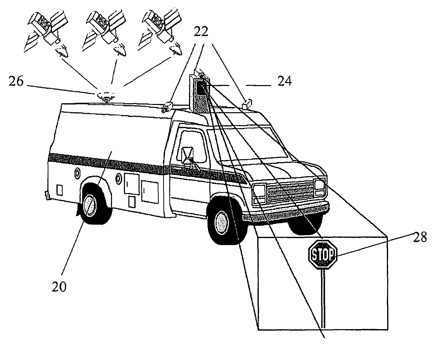
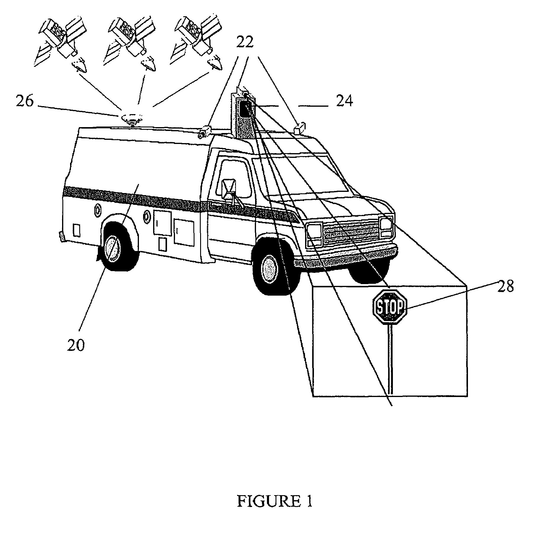
[0017]The system of the present invention can be used to perform the inventory of roadside infrastructure assets and features managed by transportation authorities (roads, public transit, railways, etc), utilities (telecommunications, electric distribution, etc), and municipalities. It is also possible to plan and monitor linear rights-of-ways (roads, railways, pipelines, electric transmission lines, etc) as well as shore evolution.

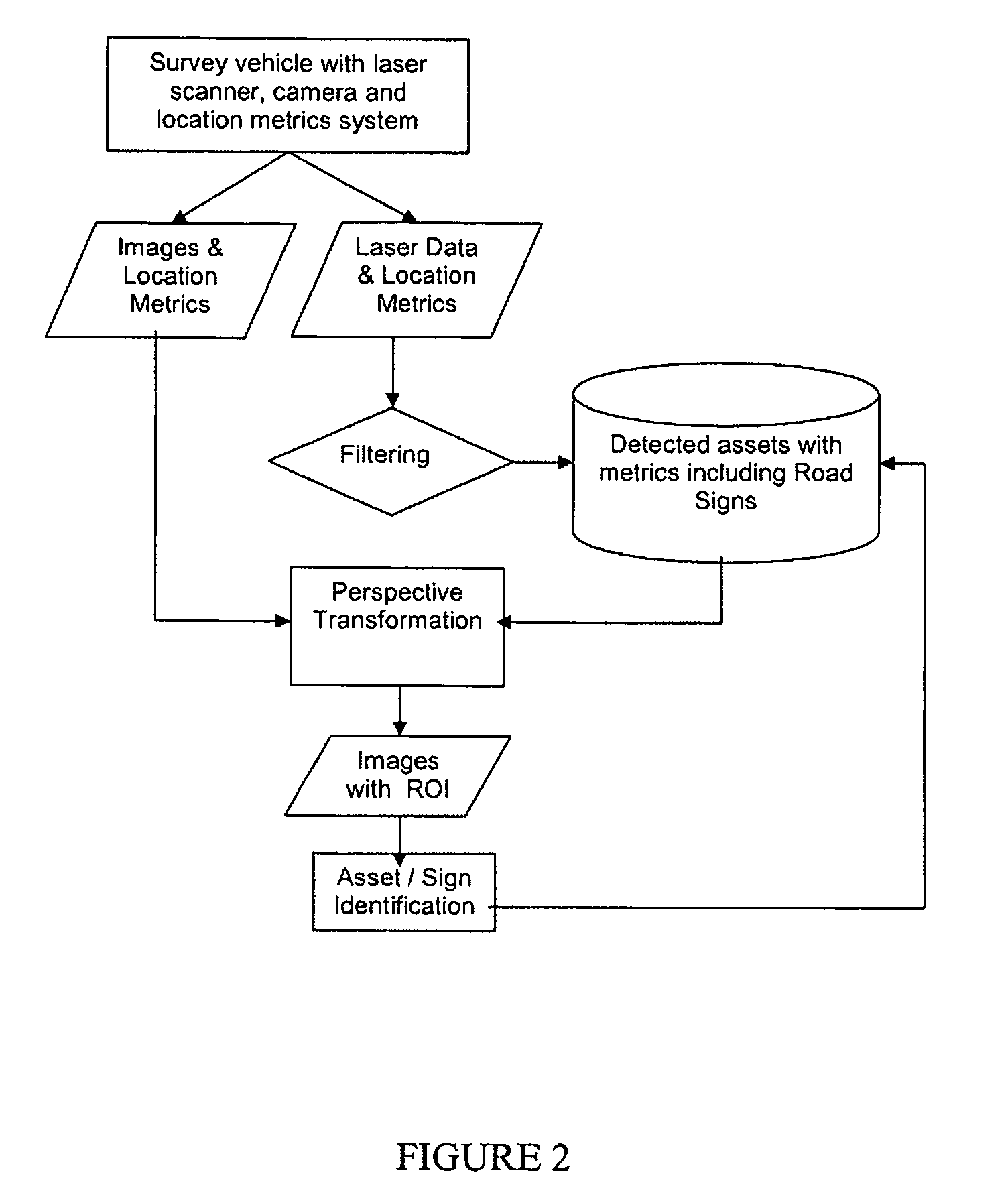
[0018]Data collection occurs in two phases. The first phase involves geo-referenced image and / or laser data collection performed on-board a land or rail vehicle. The second phase involves data extraction. This may be done either onboard the vehicle if the appropriate software is provided, or it may be undertaken by a computer that is not onboard the vehicle. A preferred embodiment of the system is based on the use of data acquisition and extraction software components coupled to high resolution cameras, 2D laser scanning devices, and / or positioning system...


PUM


Abstract

From a survey vehicle, two types of data are obtained: images from a camera and reflections from a laser. The laser data is filtered in order to detect assets. The detected assets are then processed to locate and measure the assets. Once this information has been obtained, it is combined with the images captured by the camera in order to recognize the assets.

Description

CROSS-REFERENCE TO RELATED APPLICATIONS[0001]The present claims priority of U.S. Provisional Patent Application No. 60 / 760,403 filed on Jan. 20, 2006.TECHNICAL FIELD[0002]The present invention relates to the field of automated asset management systems, and more specifically, to devices and methods used to detect, locate geographically, measure, and recognize objects found within right-of-ways.BACKGROUND OF THE INVENTION[0003]Several factors act as incentives for public and private organizations to build the equipment inventory of their infrastructure network. These may originate due to legislature or are associated with operations relative to maintenance, procurement, traffic, valuation, or safety and emergency response issues.[0004]Geographic information systems (GIS) are used to meet these goals in several fields, including those of transportation, electric distribution, and property assessments. Meanwhile, asset managers are interested in populating their customized GIS applicati...

Claims


Application Information

Patent Timeline
Patent Type & Authority Patents(United States)
IPC IPC(8): G01B11/14G06Q10/04
CPCG01C11/02G06K9/3241G01C15/00G06V10/255
Inventor LAFLAMME, CLAUDE
Owner GEO 3D
Why Eureka
Try Eureka