Automated asset positioning for location and inventory tracking using multiple positioning techniques

a technology of asset positioning and positioning technique, applied in direction finders using radio waves, instruments, data processing applications, etc., can solve the problems of radio-wave positioning, inherited noise, and inability to achieve 100% reliability or accuracy of real-time positioning systems, so as to accurately locate inventory, correct noise or errors, and high accuracy of positioning systems

Inactive Publication Date: 2010-01-12
MI JACK PRODS
View PDF42 Cites 101 Cited by
  • Summary
  • Abstract
  • Description
  • Claims
  • Application Information

AI Technical Summary

Benefits of technology

[0009]Embodiments of the present invention provide an improved method to intelligently combine multiple sensing systems and multiple positioning algorithms to obtain and report real-time position data with improved accuracy. In addition to real-time position data, the embodiments also provide post processing correction in a timely fashion as multiple data signals are received.
[0010]The invention employs multiple positioning systems and positioning algorithms or techniques to provide the real-time position of an asset being tracked. Either individual assets or multiple assets can be tracked at the same time. Assets can be processed by sensors locally on board the asset or external to the asset, with locations for some assets being processed in a centralized server or processors. Examples of the positioning systems used include DGPS, DGPS with RTK correction, DGPS / INS integration, machine vision with map integration, ultra wideband positioning system and RTLS. Different positioning methods, such as loosely-coupled DGPS / INS, tightly-coupled DGPS / INS, deeply-coupled DGPS / INS, DGPS integration with motion sensors, DGPS integration with dead-reckoning, GPS integration with RTLS as well as position error correction algorithms can also be used to provide one or more of the positioning techniques to improve the raw position data accuracy and provide motion data. The multiple position data of one or more assets can be stored in a data storage medium through wired or wireless communication.
[0011]Embodiments of this invention purposely include complementary and redundant algorithms to increase accuracy of sensor data. A position fusion or refining algorithm uses appropriate mathematical, statistical, or logical formulas to compute a new calibrated real-time position using the position data from multiple sources to result in a more accurate position than individual positioning systems can provide. The position fusion algorithm is intended to take advantage of the strength of some positioning techniques to compensate for the weaknesses of others. It will correlate linear and angular data using model-based or statistical analysis or heuristic approaches. It can use the stored movement history or external dynamic information to modify or identify the statistical properties or the confidence level of each position data point received, or to support the re-computation of a new real-time position. Some embodiments further allow the employment of positioning algorithms with different parameters but the same set of sensors to explore the inherited advantages of each different position integration algorithm.
[0013]Other available information is further used to support the determination or computation of a more accurate real-time position or more trustworthy past movement history. In one embodiment, a digital map of the storage facilities is used to improve the accuracy of the real-time position data or the adjusted past trajectory. In another embodiment data relating to the moving asset can be used to improve the accuracy of any corresponding position data, including detection sensor outputs indicating that the asset is arriving at a specific location, or RFID type or other on-board sensor outputs indicating a specific operation is performed or the identification code of the asset has been accessed.
[0015]In sum, RF positioning systems, such as GPS systems, can suffer from multi-path and blockage, and most complementary integration systems, such as GPS / INS systems, can drift away from true positions when losing GPS satellites for a long period of time. Using embodiments of the present invention to provide real-time and post processing of location data, correction for the noise or errors can be enabled. For example, post-processing can clearly identify the equivalent noise and drift terms in INS data collected after a GPS system that was inoperative has regained sufficient coverage. The post-processed positioning technique can fit the INS position solutions with respect to the segments of the “good” GPS data to accurately locate inventory in the “bad” GPS coverage areas, and resolve trustworthy past position locations even in the “bad” GPS coverage segments. The combination of multiple positioning sensor systems and the iterative application of the post-processing error correction algorithms creates a highly accurate positioning system for a reliable asset and inventory tracking system.

Problems solved by technology

Limitations in physics, however, generally prevent real-time positioning systems from achieving 100% reliability or accuracy.
Examples of those limitations with respect to radio-wave positioning include obstacles blocking line of sight position signals, or signals reflected from nearby surfaces (multi-path).
Further practical limitations in sensor technologies include electromagnetic and other inherited noise and biases in measurements, as well as a poor signal to noise ratio resulting from environmental interference sources.
These limitations result in common positioning errors such as inaccuracies, loss of position, or location drifts causing erroneous position or inventory data.
Even when more accurate real-time position data can be determined through a combination of sensors, data and methods, these solutions do not solve another important problem in the inventory and resource tracking environment, namely what happens when at least a portion of the real-time position sensor data is inaccurate, missing or is lost?
As a simple example, a real-time positioning system based on an expensive integrated GPS / INS solution can drift away from the true positions when the system enters an area covered by less than four GPS satellites for a long period of time.
In a typical inventory tracking environment, inaccurate location measurements, if not corrected in time, can propagate into widespread inventory location errors.
This occurs especially when tracking the position of containers or vehicles in a warehouse, container yard, or rail yard where tracking signals are often blocked.
The correction of the corrupted inventory database can create delays and often expensive corrective measures in resource management and inventory controls.
In sum, RF positioning systems, such as GPS systems, can suffer from multi-path and blockage, and most complementary integration systems, such as GPS / INS systems, can drift away from true positions when losing GPS satellites for a long period of time.

Method used


Image

  • Automated asset positioning for location and inventory tracking using multiple positioning techniques
  • Automated asset positioning for location and inventory tracking using multiple positioning techniques
  • Automated asset positioning for location and inventory tracking using multiple positioning techniques

Examples


Embodiment Construction

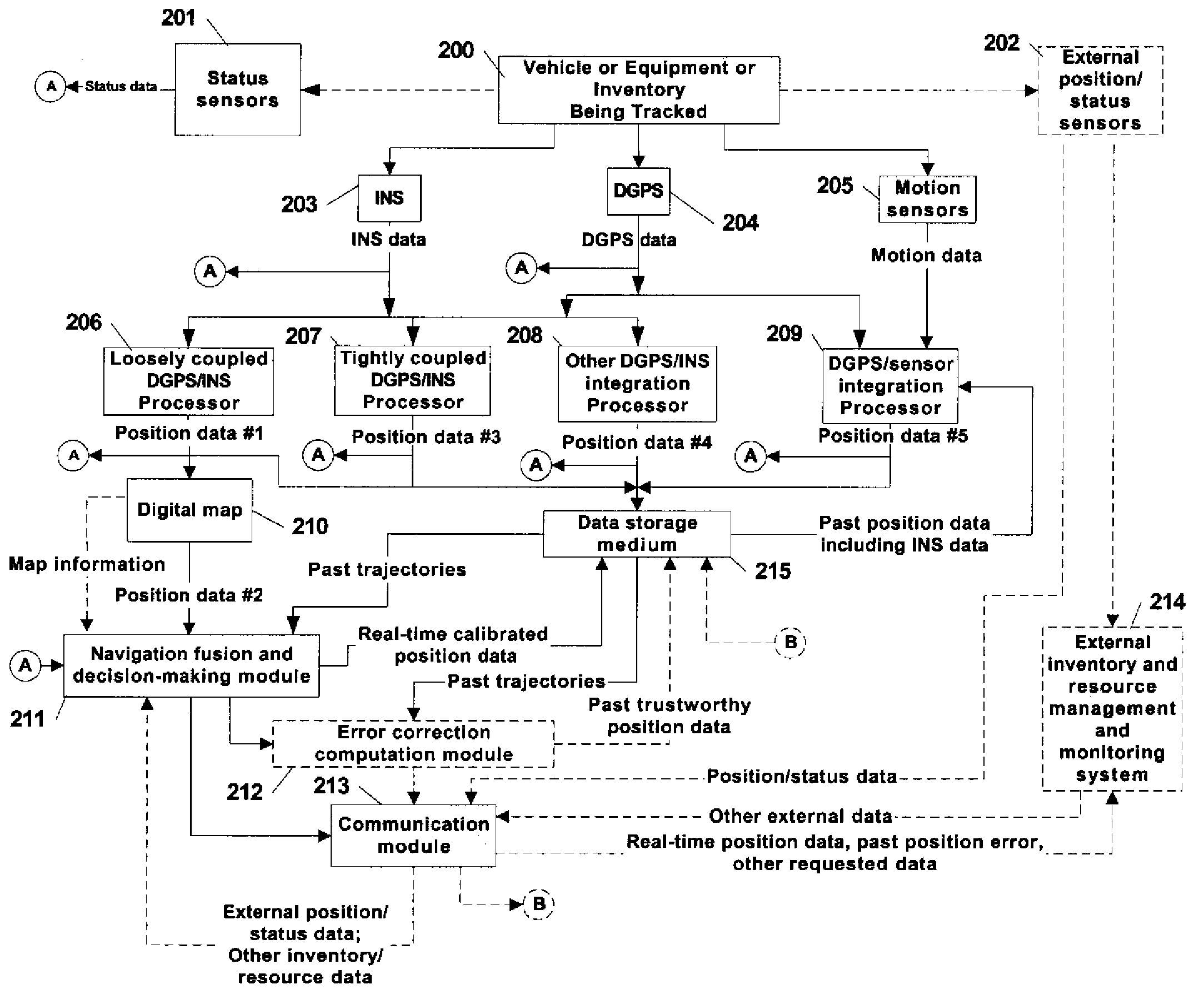
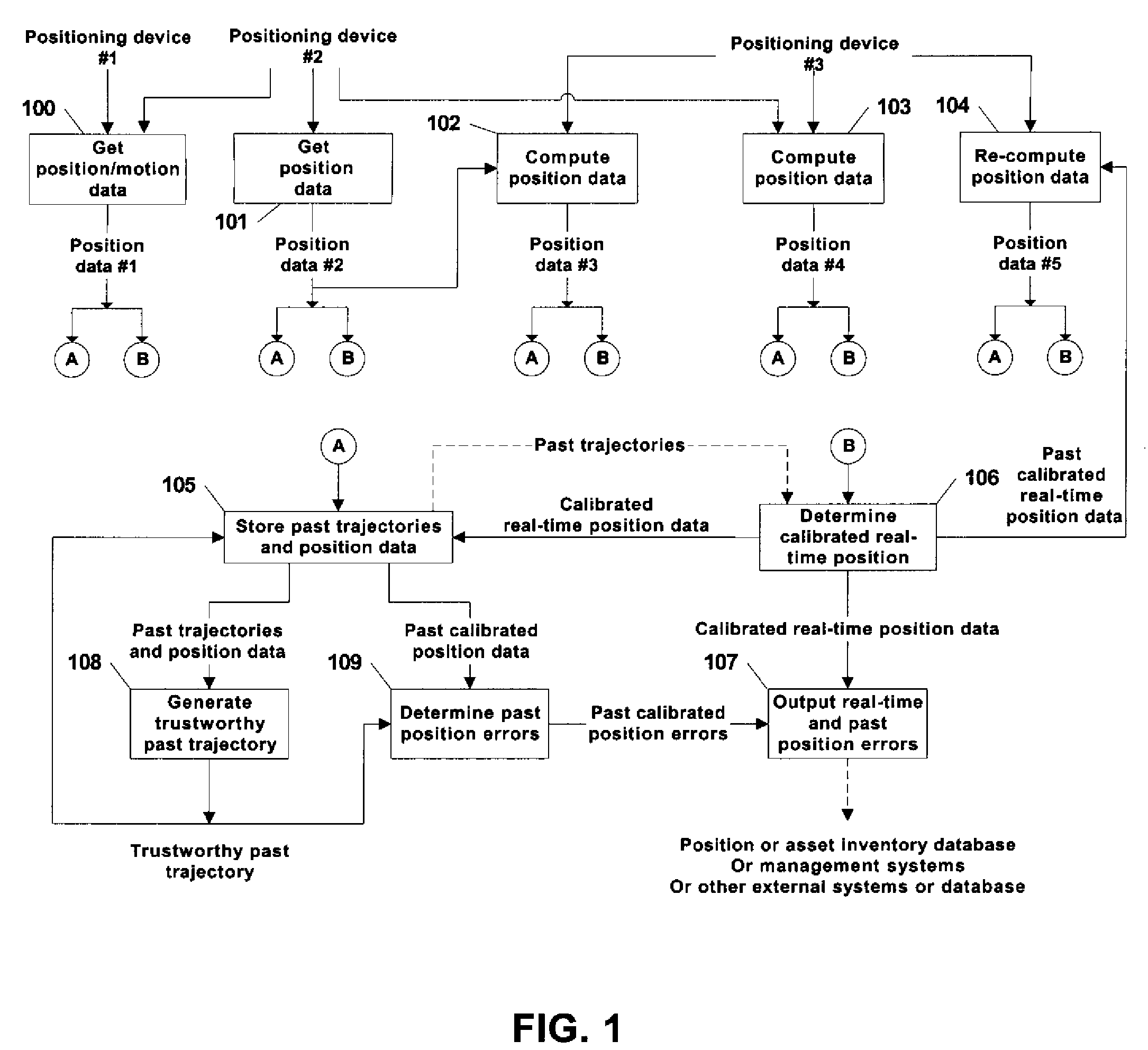
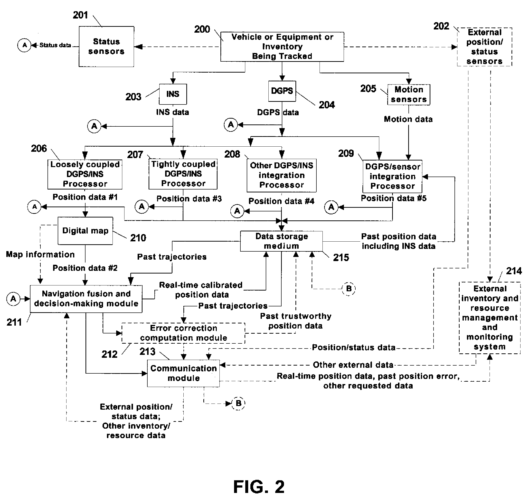
[0023]FIG. 1 is a flowchart illustrating basic operation of a method for integrating real-time positions and correcting past trajectory of a mobile object using multiple positioning techniques. Initially in FIG. 1, real-time position data is computed in step 100, step 101, step 102 and step 103 from positioning devices #1, positioning devices #2 and positioning devices #3. For example, a first embodiment may select an INS system for positioning devices #1, a DGPS system for positioning devices #2, and motion sensors for positioning devices #3. A second embodiment may choose a different set of positioning devices, such as an integrated DGPS / INS system for positioning devices #1, a DGPS system with RTK correction for positioning devices #2, and RTLS (Real-Time Locating System) for positioning system #3. The positioning devices #1, #2 and #3 can be complementary and / or redundant. It is understood that an individual embodiment may have different numbers of positioning devices as well as...


PUM


Abstract

A system and method is provided for tracking and maintaining a highly accurate inventory of shipping containers that are stored within container storage facilities. The invention includes using multiple complementary real-time and post-processing positioning techniques associated with various positioning sensors that are associated with inventory pieces or equipment. Examples of such positioning techniques are DGPS, GPS with RTK, DGPS loosely-coupled with INS, DGPS tightly-coupled with INS, and DGPS deeply-coupled with INS. Data correction and fusion techniques are applied to these positioning stages to re-compute a calibrated position with an improved accuracy. An additional trajectory can be iteratively determined using the fusing technique until the position data becomes statistically trustworthy. Further, combinations of multiple real-time positioning techniques combined with past position error correction algorithms provide a high accuracy needed for inventory tracking.

Description

CLAIM OF PRIORITY[0001]This Patent Application claims the benefit of U.S. Provisional Application No. 60 / 785,585 entitled “AUTOMATED ASSET POSITIONING FOR LOCATION AND INVENTORY TRACKING USING MULTIPLE POSITIONING TECHNIQUE,” by Tan et al., filed Mar. 24, 2006.BACKGROUND[0002]1. Technical Field[0003]The present invention relates to tracking the precise location of assets by either tracking the equipment that moves them or tracking the assets themselves. More particularly, the present invention relates to the tracking and inventorying of containers, within container storage facilities, by combining multiple positioning techniques that involve using a satellite Global Positioning System (GPS), an Inertial Navigation System (INS), or other movement or status sensors for position determination.[0004]2. Related Art[0005]Position or location tracking is a crucial component of inventory or resource management systems. Location tracking systems can employ real-time positioning sensors that ...

Claims


Application Information

Patent Timeline
Patent Type & Authority Patents(United States)
IPC IPC(8): G01S5/14G01S3/02G01S19/09G01S19/49
CPCG01S19/49G06Q10/08G06Q10/087G01S19/485
Inventor TAN, HAN-SHUEWARF, GREGORY KEITHHENRY, LARRY
Owner MI JACK PRODS
Why Eureka
Try Eureka