Method for mapping spaces with respect to a universal uniform spatial reference

a mapping method and universal technology, applied in the direction of navigation instruments, instruments, process and machine control, etc., can solve the problems of significant errors in gps-poor outdoor regions, inability to provide gps satellite signals indoors or wherever they are available, and lack of gps pervasiveness

Active Publication Date: 2010-04-06
ORMON CORP
View PDF5 Cites 133 Cited by
  • Summary
  • Abstract
  • Description
  • Claims
  • Application Information

AI Technical Summary

Problems solved by technology

One problem with creating such maps, however, is that GPS currently is not pervasive.
It is not available indoors or wherever GPS satellite signals are blocked or weak, such as in areas with heavy forestation or in dense urban areas such as older sections of European and Asian cities.
While methods exist that estimate and extrapolate GPS coordinates through signal-less spaces, these result in significant errors in GPS-poor outdoor regions.
Indoors, GPS is not used, so few up-to-date, automated “as-built” building interior floor plans exist, globally positioned or not.
Since buildings rarely are built exactly as specified by the architect, the CAD drawing of the interior spaces usually does not even fit the building's actual exterior footprint.
This method requires enormous amounts of computer processing, which slows results.
In add...

Method used


Image

  • Method for mapping spaces with respect to a universal uniform spatial reference
  • Method for mapping spaces with respect to a universal uniform spatial reference
  • Method for mapping spaces with respect to a universal uniform spatial reference

Examples


Embodiment Construction

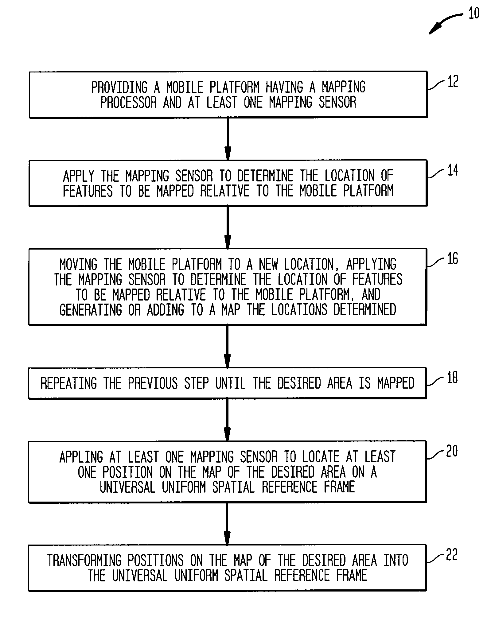
[0022]An exemplary method 10 for generating maps of a desired area that are referenced to a universal uniform spatial reference frame is illustrated in FIG. 1. In one embodiment, the universal uniform spatial reference frame can be the GIS, and coordinates on the map can be provided in the format used by the GPS. As used herein, GIS refers to Global Information System, a generic term for a spatial database in which the spatial information is linked to GPS coordinates. Similarly, GPS refers to the Global Positioning System in which radio systems, typically satellite-based, provide three-dimensional position and time information to which suitably equipped receivers anywhere on or near the surface of the Earth compute their global position, velocity and orientation (heading).

[0023]In step 12 in the illustrated method, a mobile platform is provided with a mapping processor and at least one mapping sensor. The mapping sensor is then applied 14 to locate features to be mapped relative to ...


PUM


Abstract

A method for generating maps of a desired area that are referenced to a universal uniform spatial reference frame includes a mobile platform having a mapping processor and at least one mapping sensor is provided. The mapping sensor is applied to determine the location of features to be mapped relative to the mobile platform. The mobile platform is moved to a new location, and the mapping sensor is further applied to determine the location of features to be mapped relative to the mobile platform. These steps are repeated until the desired area is mapped. The at least one mapping sensor is also applied to locate at least one position on the map of the desired area on a universal uniform spatial reference frame. Positions on the map of the desired area are transformed into the universal uniform spatial reference frame.

Description

RELATED APPLICATIONS[0001]This application claims priority to U.S. Provisional Patent Application Ser. No. 60 / 739,852, filed on Nov. 23, 2005 and entitled “Method for Improved Globally Referenced Mapping of Spaces with Inadequate Satellite Reception, which application is incorporated herein by reference in its entirety.BACKGROUND OF THE INVENTION[0002]Creating spatial representations of the world for use in decision-making, navigation and many other applications, has grown into an enormous GIS (Geographical Information System, or sometimes, Global Information System) that links natural and man-made features with their relative and unique 3-D positions on or near Earth. Data include Earth topography and vegetation, as mostly gathered by satellite imagery. Other Features, such as the centerline of a road, are gathered by driving a vehicle with a GPS (Global Positioning System) system and noting the location of intersections and waypoints. Utility locations are input by surveying with ...

Claims


Application Information

Patent Timeline
IPC IPC(8): G01C21/00
CPCG01C21/20G05D1/0272G05D1/0274G05D1/024G05D1/0261G05D1/0234G05D2201/0207
Inventor DIETSCH, JEANNEKENNEDY, WILLIAM
Owner ORMON CORP
Why Eureka
Try Eureka