System framework for mobile device location

a mobile device and system framework technology, applied in the field of determining location, can solve the problems that the access-point-based system has not yet demonstrated its viability, and achieve the effect of easy and efficient measurement, quick and inexpensive compilation and maintenan

Active Publication Date: 2011-08-09
ETHERWHERE CORP
View PDF15 Cites 132 Cited by
  • Summary
  • Abstract
  • Description
  • Claims
  • Application Information

AI Technical Summary

Benefits of technology

[0013]In general, the object of the present invention is to provide an MDLS framework to enable the rapid and inexpensive compilation and maintenance of a comprehensive Beacon Survey Database, with the accuracy required by current and contemplated location-based applications. As the repository for field measureme...

Problems solved by technology

While cell-tower-based systems have proven their viability in the mark...

Method used


Image

  • System framework for mobile device location
  • System framework for mobile device location
  • System framework for mobile device location

Examples


Embodiment Construction

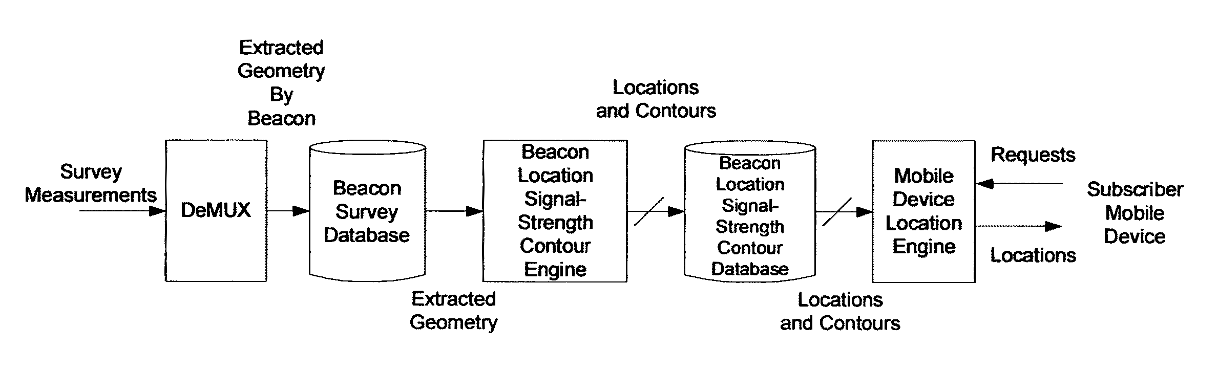
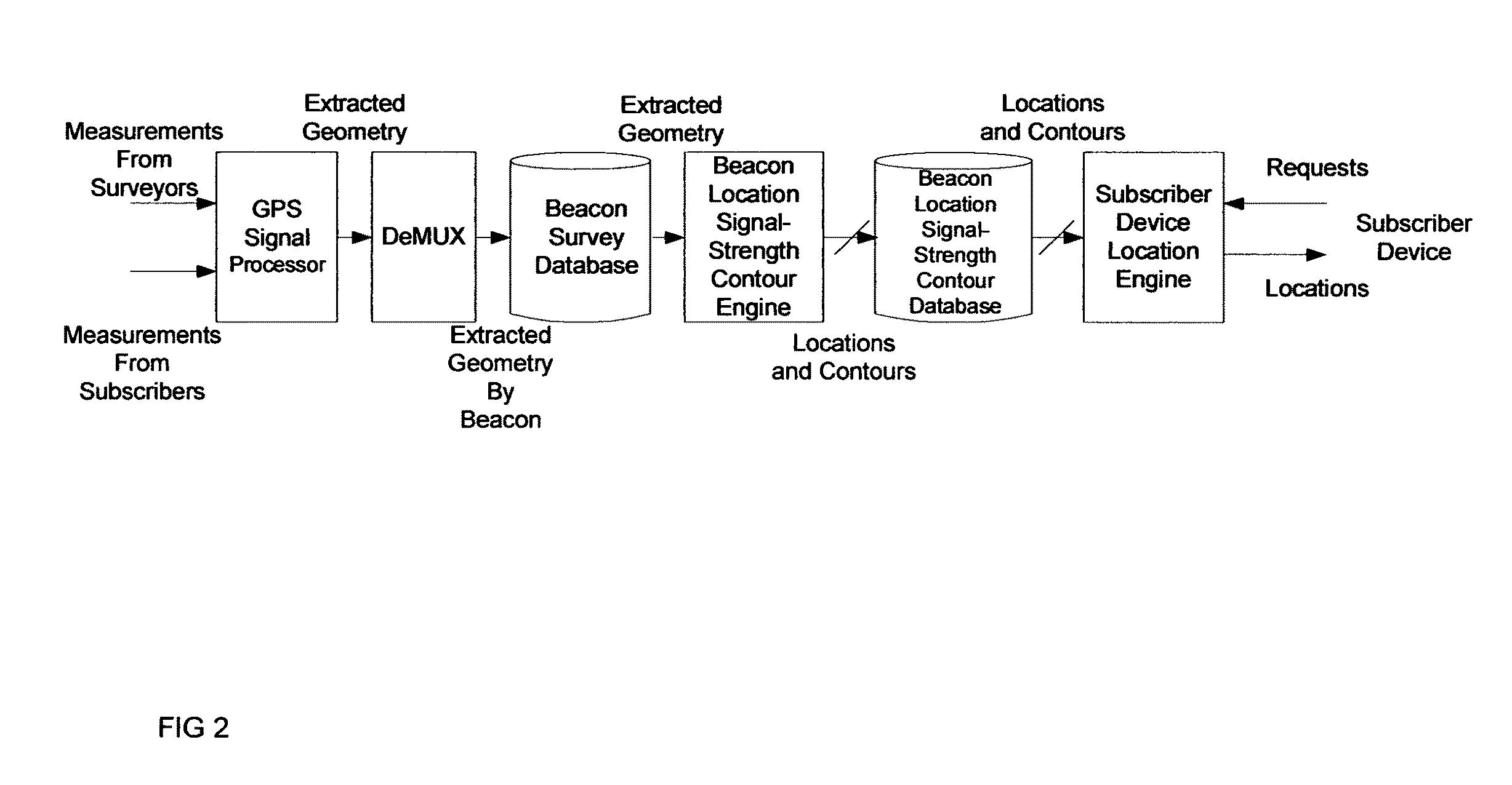
[0044]In general, the object of the present invention is to provide an MDLS framework to enable the rapid and inexpensive compilation and maintenance of a comprehensive Beacon Survey Database, with the accuracy required by current and contemplated location-based applications. As the repository for field measurements, applied ultimately to estimate the locations of subscribers' mobile devices, the Beacon Survey Database influences virtually every metric of importance to the operators as well as the subscribers of location services. Measurements must be easily and efficiently obtained, using accurate but inexpensive instruments.

[0045]The framework of today's mobile device location systems, which exist to address the occasional failure of on-board GPS, is based on GPS, the implicit premise being that when on-board GPS fails, the network will be able to provide a GPS-based estimate of the location using cues (beacon ID's, signal strengths) supplied by the mobile device. This premise is ...


PUM


Abstract

A method for estimating the location of a beacon from an ensemble of measurements associated with said beacon, where, contained in each measurement, are GPS data from which surfaces of location may be extracted, together with the ID's of beacons detectable at the point of measurement, is disclosed. The method comprises extracting the canonical set of surfaces of location implicit in each of the associated measurements, and determining the estimate of the location of the beacon as the point for which the sum of the squares of the distances to each of the surfaces so extracted is minimized. A system for the compilation of a database of beacon locations from measurements containing a time-stamped recording of the composite GPS signal (which recording is referred to as a datagram), together with the ID's and associated signal strengths of beacons detectable at the point of measurement, is also disclosed. The system comprises GPS signal processing means for extracting, from each time-stamped datagram, the canonic set of surfaces of location, and beacon location estimation means for estimating the location of a beacon from an ensemble of surfaces of location associated with said beacon.

Description

CROSS-REFERENCE TO RELATED APPLICATIONS[0001]This application claims priority under 35 U.S.C. ξ120 from pending U.S. patent application Ser. No. 12 / 587,096 and Ser. No. 12 / 587,099, entitled “Signal Processing Techniques for Improving the Receive Sensitivity of GPS Receivers” filed on Oct. 2, 2009, the subject matter of which is incorporated herein in its entirety. This application further claims priority under 35 U.S.C. ξ120 from pending U.S. patent application Ser. No. 12 / 387,888 and Ser. No. 12 / 387,889, entitled “Signal Processing Techniques for Improving the Receive Sensitivity of GPS Receivers” filed on May 9, 2009, the subject matter of which is incorporated herein in its entirety. This application further claims priority from pending U.S. patent application Ser. No. 12 / 220,612, entitled “Method and Apparatus for Determining Location” filed on Jul. 25, 2008, the subject matter of which is incorporated herein in its entirety.STATEMENT REGARDING FEDERALLY SPONSORED RESEARCH OR DE...

Claims


Application Information

Patent Timeline
IPC IPC(8): G01S1/08
CPCG01S5/0242G01S19/10G01S5/0249
Inventor FARROKHI, FARROKHLEE, EDMUND GREGORYWONG, DICKSON T.COLLMEYER, ARTHUR J.
Owner ETHERWHERE CORP
Why Eureka
Try Eureka