Prioritizing node requests based on tile distance to reduce perceptual scene time

a tile distance and node technology, applied in the field of geoinformation systems, can solve the problem that the client may not be able to request all data, and achieve the effect of reducing the time of user-perceived scene resolution

Active Publication Date: 2016-04-19
GOOGLE LLC
View PDF2 Cites 3 Cited by
  • Summary
  • Abstract
  • Description
  • Claims
  • Application Information

AI Technical Summary

Benefits of technology

[0006]Embodiments relate to methods for prioritizing data packets using tile distance to render a three dimensional environment. An exemplary method for reducing user-perceived scene resolution time to render a node tree in a three dimensional environment includes identifying a first cache node in the node tree at a first level of detail. The first cache node is located within a field of view of a virtual camera that defines a perspective to view content of the three-dimensional environment. The exemplary method also includes computing a first priority score based at least on a depth in the node tree of the first level of detail and a first number of tiles at the first level of detail between the first cache node and a location of the virtual camera in the three-dimensional environment. The exemplary method further includes identifying a second cache node in the node tree at a second level of detail different from the first level of detail. The second cache node is located within the field of view of the virtual camera. The exemplary method also includes computing a second priority score based at least on a depth in the node tree of the second level of detail and a second number of tiles at the second level of detail between the second cache node and the location of the virtual camera. The exemplary method further includes ordering cache node requests based at least on the relative values of the first and second priority scores.
[0007]Another exemplary method for reducing user-perceived scene resolution time to render a node tree in a three dimensional environment includes identifying a first cache node in the node tree at a first level of detail. The first cache node is located within a field of view of a virtual camera that defines a perspective to view content of the three-dimensional environment. The exemplary method also includes computing a first priority score based at least on a first number of tiles at the first level of detail between the first cache node and a location of the virtual camera in the three-dimensional environment. The exemplary method further includes identifying a second cache node in the node tree at a second level of detail different from the first level of detail. The second cache node is located within the field of view of the virtual camera. The exemplary method also includes computing a second priority score based at least on a second number of tiles at the second level of detail between the second cache node and the location of the virtual camera. The exemplary method further includes ordering cache node requests based at least on the relative values of the first and second priority scores.

Problems solved by technology

A client may not be able to request all data that it needs from a server to resolve a view that satisfies a user because there is a maximum amount of data that the client may request from the server at any one time.

Method used


Image

  • Prioritizing node requests based on tile distance to reduce perceptual scene time
  • Prioritizing node requests based on tile distance to reduce perceptual scene time
  • Prioritizing node requests based on tile distance to reduce perceptual scene time

Examples


Embodiment Construction

[0020]I. Overview

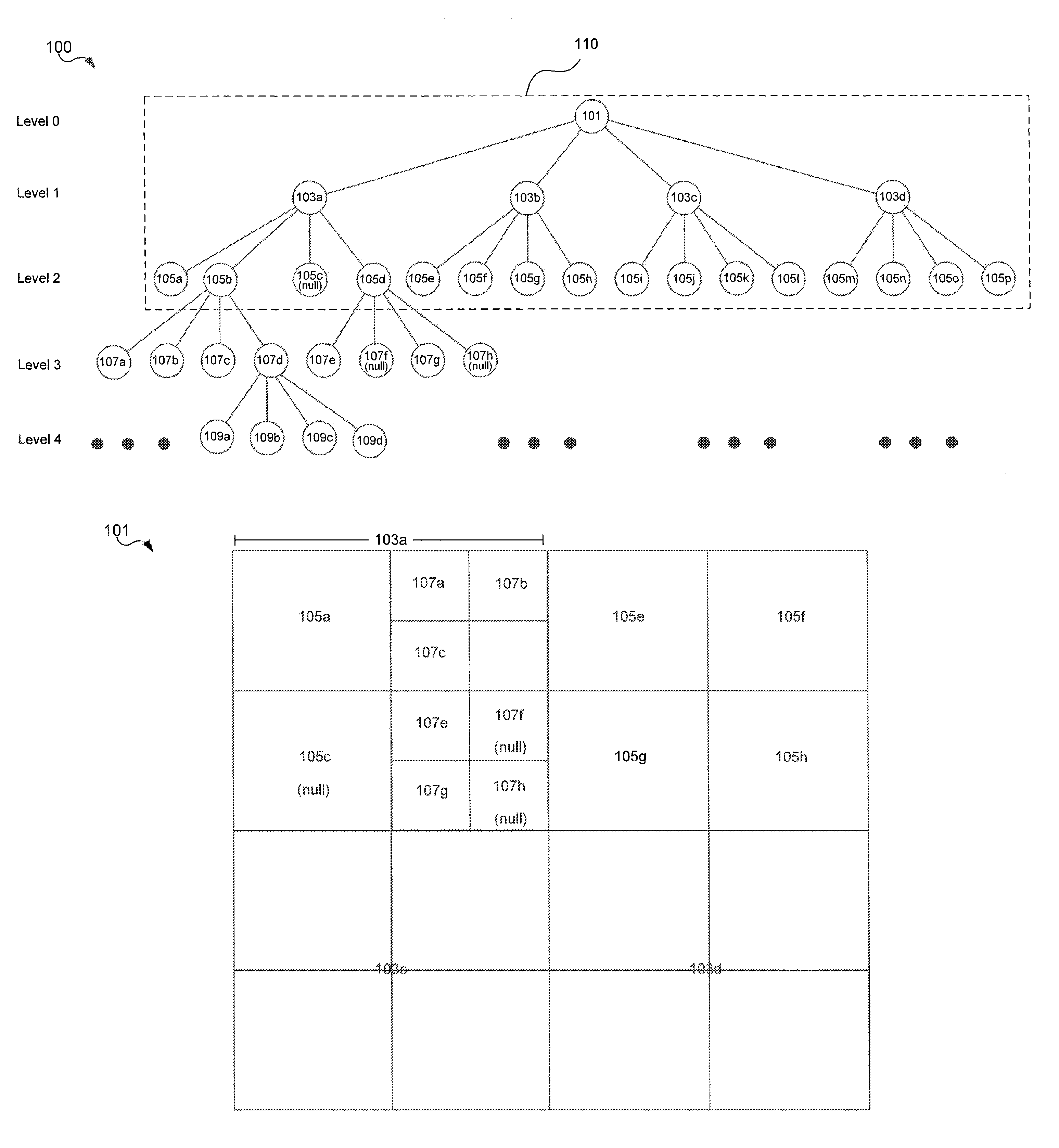
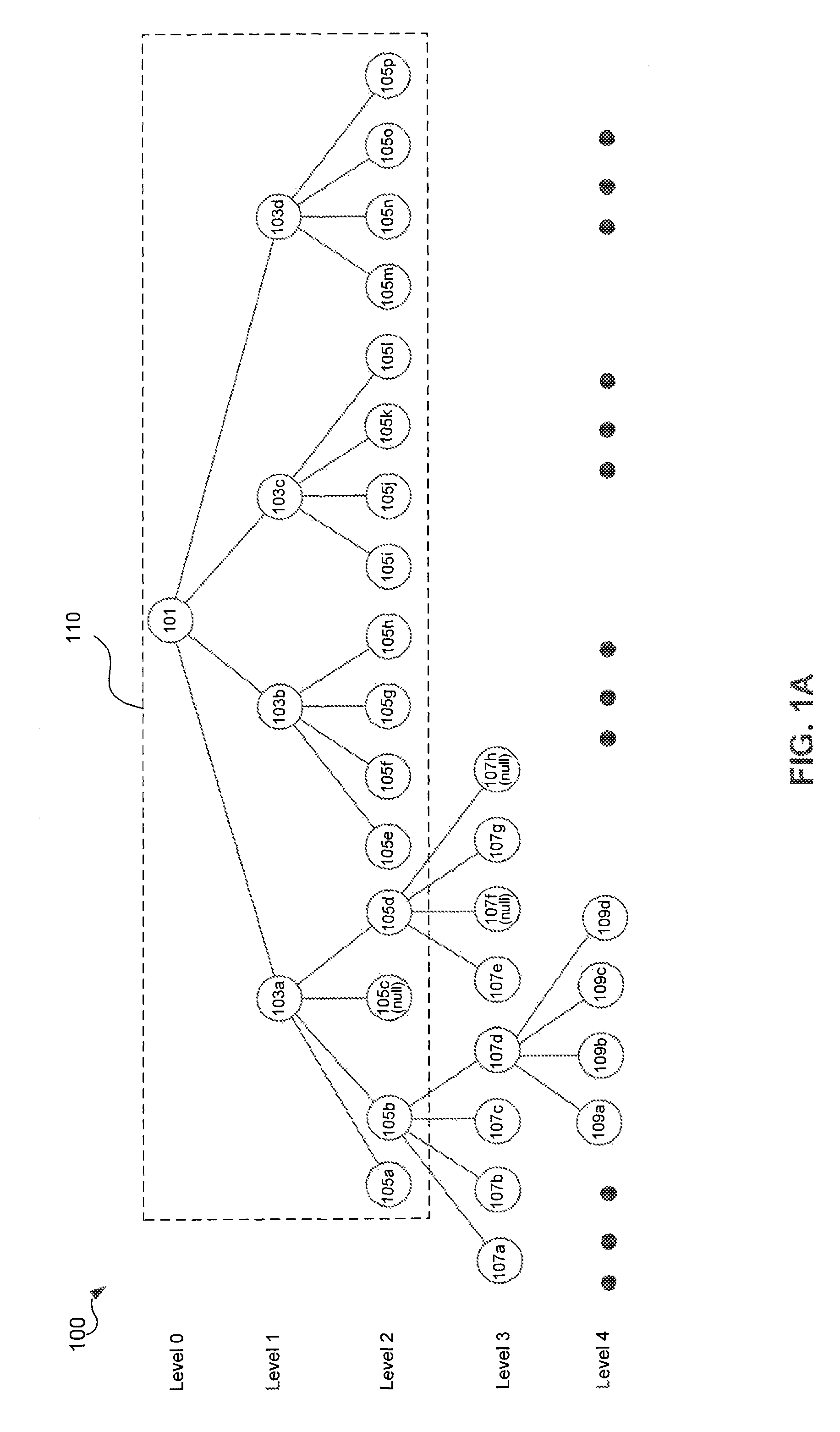
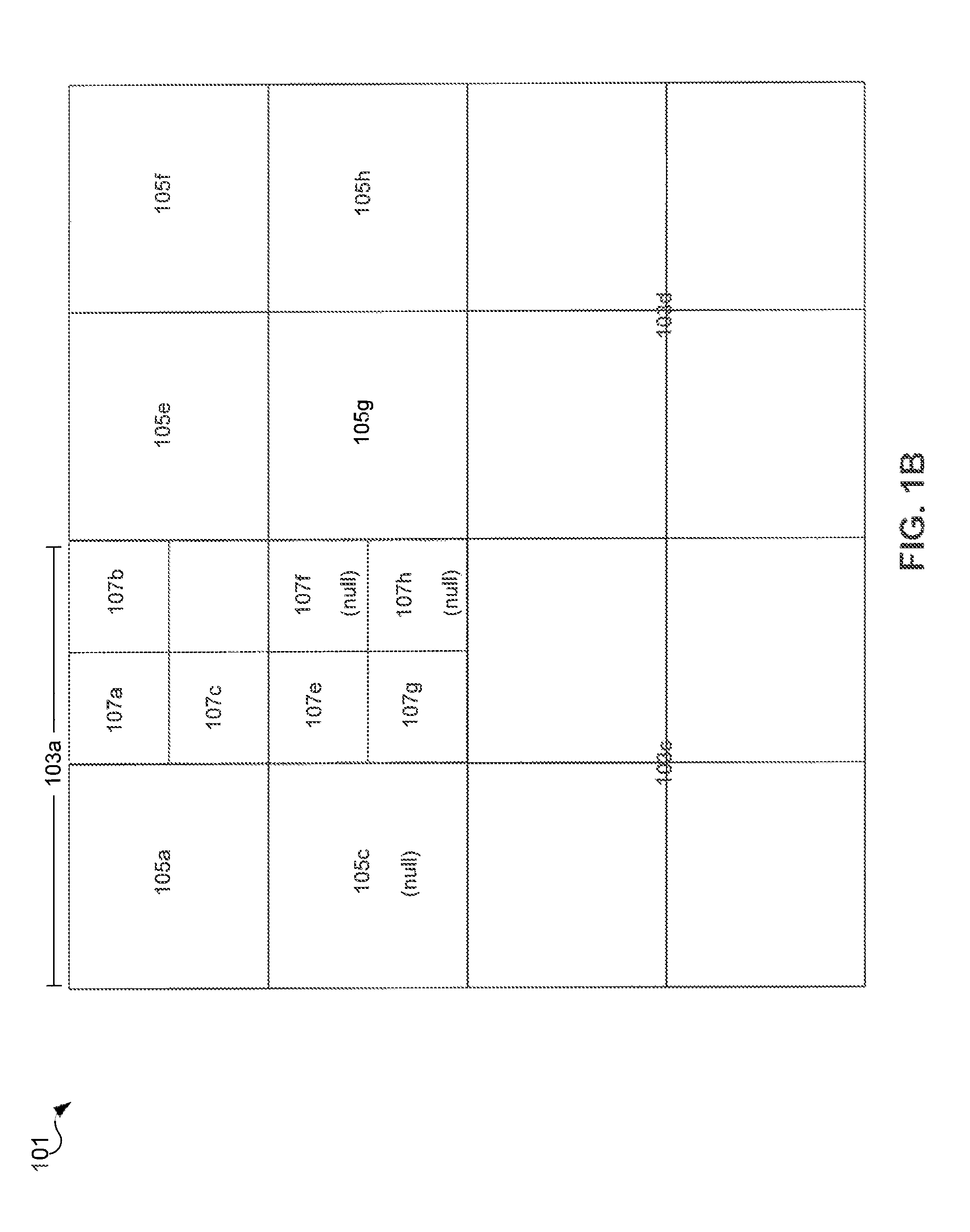
[0021]II. Quadtrees[0022]A. Tree Representation[0023]B. Grid Representation

[0024]III. Cache Node Priority Score[0025]A. Geographic Distance[0026]B. Tile Distance[0027]C. Cache Node Types[0028]1. Types of Cache Nodes[0029]2. Examples of Cache Node Constraints[0030]3. Offsets[0031]D. Primary and Secondary Factors

[0032]IV. Exemplary Client Architecture

[0033]V. Exemplary Method

[0034]VI. Conclusion

I. Overview

[0035]This description generally relates to data packet prioritization in a three-dimensional environment. A client may display a view of the planet by requesting cache nodes from a server and loading the cache nodes. In an embodiment, a client may order cache node requests before they are sent to a server based on a priority score associated with the cache node. The priority score indicates a priority of the cache node relative to other cache nodes. The cache nodes may be ordered such that data which visually matters to a user is fetched first. A priority score may ...


PUM


Abstract

An exemplary method for reducing user-perceived scene resolution time to render a node tree in a three-dimensional environment includes identifying a first cache node in the node tree at a first level of detail. The exemplary method also includes computing a first priority score based at least on a depth in the node tree of the first level of detail and a first tile distance. The exemplary method further includes identifying a second cache node in the node tree at a second level of detail different from the first level of detail. The exemplary method also include computing a second priority score based at least on a depth in the node tree of the second level of detail and a second tile distance. The exemplary method further includes ordering cache node requests based at least on the relative values of the first and second priority scores.

Description

BACKGROUND[0001]1. Field[0002]This disclosure relates to geographic information systems (GIS) and in particular to data packet prioritization to render a three dimensional environment.[0003]2. Background[0004]A geographic information system (GIS) is a system for archiving, retrieving, displaying, or manipulating data indexed according to the data elements' geographic coordinates. The data elements may be a variety of data types such as, for example, satellite imagery, maps, models of buildings and terrain, and other geographic features.[0005]GIS applications communicate with a server to retrieve data that is requested for display on a client device. A client may not be able to request all data that it needs from a server to resolve a view that satisfies a user because there is a maximum amount of data that the client may request from the server at any one time. Usability of GIS applications depends on displaying content quickly and smoothly.BRIEF SUMMARY[0006]Embodiments relate to m...

Claims


Application Information

Patent Timeline
Patent Type & Authority Patents(United States)
IPC IPC(8): G06F7/00G06T15/00
CPCG06T15/005
Inventor KORNMANN, DAVID
Owner GOOGLE LLC
Why Eureka
Try Eureka