Circular navigation method for navigation instrument

A navigation method and navigator technology, which is applied to road network navigators, navigation, surveying and mapping, and navigation, etc., can solve problems such as the complexity of the navigation process around the island, and achieve the effect of improving the efficiency of navigation around the island, intuitive navigation around the island, and satisfying usage habits

Inactive Publication Date: 2007-10-03
江苏华科导航科技有限公司
View PDF1 Cites 10 Cited by
  • Summary
  • Abstract
  • Description
  • Claims
  • Application Information

AI Technical Summary

Problems solved by technology

The system's round-the-island navigation process is complex

Method used


Image

  • Circular navigation method for navigation instrument
  • Circular navigation method for navigation instrument
  • Circular navigation method for navigation instrument

Examples


Embodiment 1

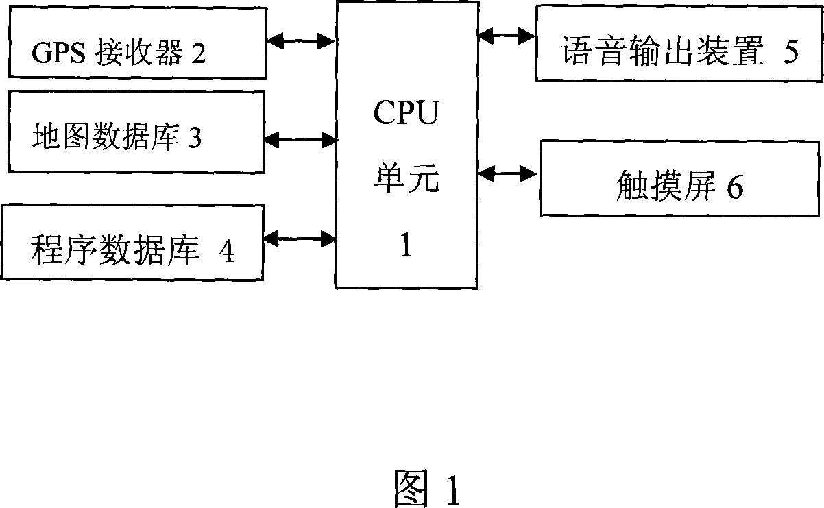
[0022] As shown in Fig. 1, the navigator of the present embodiment comprises: CPU unit 1, the GPS receiver 2 that is electrically connected bidirectionally with CPU unit 1, the map database 3 that is used to store the digital map that is electrically connected with CPU unit 1 bidirectionally, and CPU unit A bidirectionally electrically connected program database 4 for storing navigation programs, a bidirectionally electrically connected voice output device 5 with the CPU unit 1, and a bidirectionally electrically connected touch screen 6 with the CPU unit 1. The navigator carrier can be mobile carriers such as automobiles and motorcycles.

[0023] The CPU unit 1 includes a CPU for program control and data calculation, a ROM for storing the bottom layer software of the navigator and basic setting data, that is, a program database 4, and a RAM for storing programs and data when the software is running; the map database 3 stores and executes Programs, POI data, retrieved data, et...


PUM


Abstract

The roundabout navigation method of navigation instrument includes the following steps: setting the initial point and destination, calculating optimal path in CPU unit and showing the path in the touch screen to start booting process; calculating the distance between the current position and the next prompt point in CPU unit; judging whether the prompt point is a roundabout after the distance is smaller than the set threshold value; showing the enlarged map of the non-roundabout prompt point or calculating the entrance path and exit position based on the map database for roundabout prompt point before showing the enlarged map of the roundabout; and restoring the display of optimal path and current position after passing through the roundabout.

Description

technical field [0001] The invention relates to an island-rounding navigation method for a navigator. Background technique [0002] Most of the existing car navigation systems use the global positioning system to detect the current position of the vehicle, display a map marked with the current position on the display screen, and navigate to the destination along the optimal route. Intersections on the route are also displayed on the screen and indicate the heading in which the vehicle should travel. [0003] Intersections include traffic circles. As the vehicle approaches the roundabout, the direction of the vehicle through the roundabout is indicated using arrows on the screen and / or by voice. [0004] Chinese patent application 200610059862.7 discloses a car navigation system. For the connecting road connected to the traffic roundabout included in the guidance route, the car navigation system obtains a virtual link, and limits the virtual link to the direction of the tra...

Claims


Application Information

Patent Timeline
IPC IPC(8): G01C21/00G01C21/26
Inventor 秦春达李晓华
Owner 江苏华科导航科技有限公司
Why Eureka
Try Eureka