Train satellite positioning and message transmison system

An information transmission system and satellite positioning technology, applied in the field of train satellite positioning and information transmission systems, to achieve the effect of easy installation and maintenance

Active Publication Date: 2008-04-09
BEIJING JIAOTONG UNIV
View PDF0 Cites 41 Cited by
  • Summary
  • Abstract
  • Description
  • Claims
  • Application Information

AI Technical Summary

Problems solved by technology

[0007] The purpose of the present invention is aimed at the actual geographical and environmental conditions of the railway (elevation, climate, basic living conditions, etc.), some conventional equipment applications are limited, and a satellite positioning and information transmission system for tra...

Method used


Image

  • Train satellite positioning and message transmison system
  • Train satellite positioning and message transmison system
  • Train satellite positioning and message transmison system

Examples


Embodiment Construction

[0030] The present invention will be further described below in conjunction with accompanying drawing and specific embodiment:

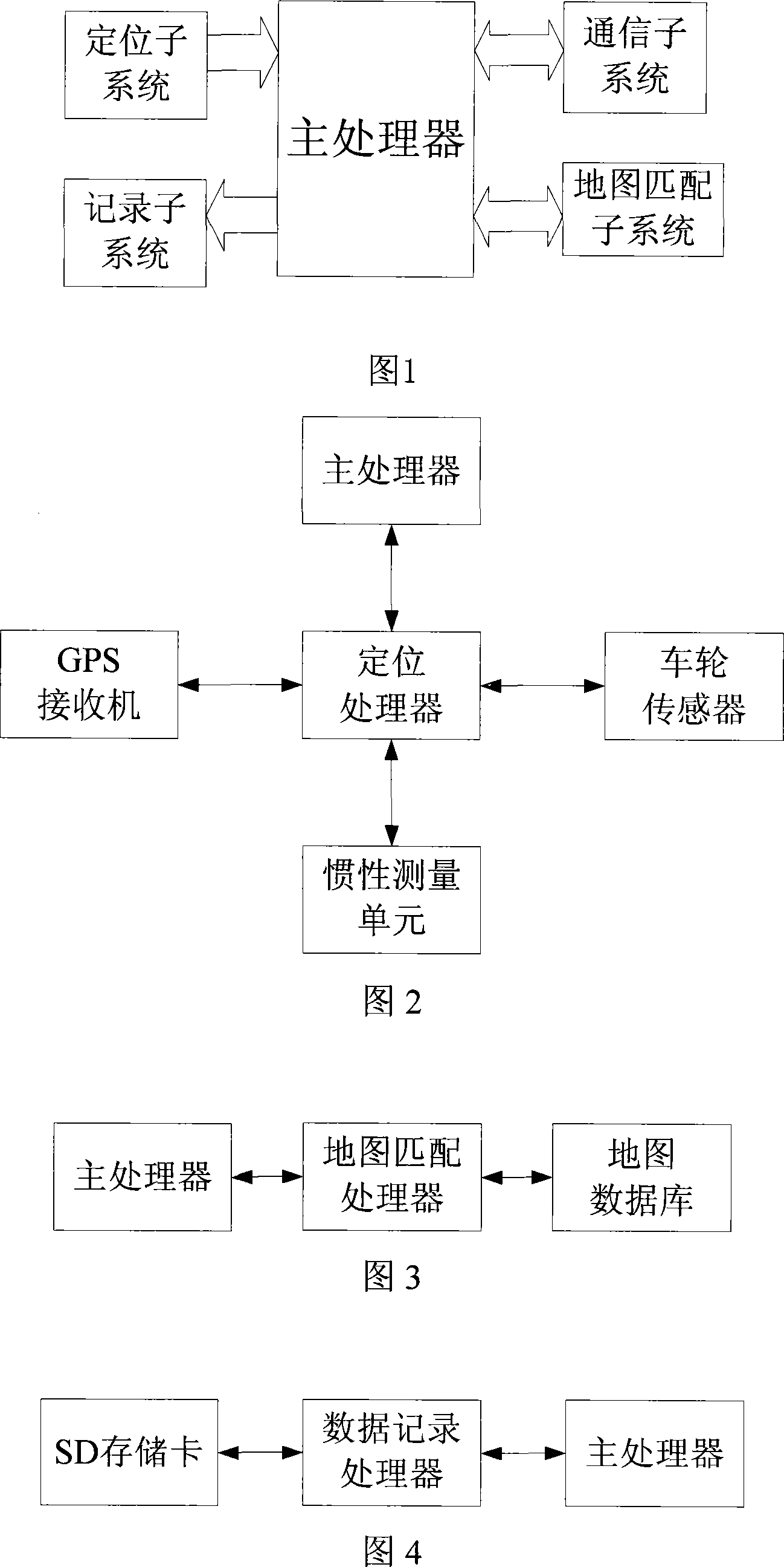
[0031] As shown in Figure 1, the train satellite positioning and information transmission system includes a main processor, a positioning subsystem, a map matching subsystem, a data recording subsystem, and a communication subsystem.

[0032] As shown in Figure 2, the positioning subsystem is composed of GPS receiver, wheel sensor, inertial measurement unit and positioning processor to provide train positioning information. The GPS receiver calculates the longitude and latitude coordinates through the satellite signal provided by the global satellite positioning system; the wheel sensor provides the vehicle speed by monitoring the wheel movement state; the inertial measurement unit provides the direction and acceleration of the vehicle movement; the positioning processor receives the GPS receiver, the wheel sensor , the raw data of the inertial measu...


PUM


Abstract

The invention discloses a train satellite positioning and information transmitting system which is suitable for the train positioning and information transmission. The system comprises a positioning subsystem, a map-matching subsystem, a data record subsystem, a communication subsystem and a main processor; wherein the positioning subsystem is used for outputting the positioning coordinates of latitude and longitude. The map-matching subsystem matches the positioning output to a data map. The data record subsystem is used for recording the data in file format in a Secure Digital memory card. The communication subsystem is used for automatically detecting the possibility of three communication signal paths and the switchover of three communication methods. The main processor is used for completing data processing and data switching. The train satellite positioning and information transmitting system is used for positioning and monitoring the train. With satellite communication, satellite integrated positioning and full-line coverage communication system, the invention meets the needs of the communication, command, dispatch, distress handling, supervision and monitoring of low density rail track.

Description

technical field [0001] The invention relates to a train satellite positioning and information transmission system, which belongs to the technical field of vehicle positioning and information transmission in the field of rail transit. Background technique [0002] Satellite positioning is a successful example of modern high-tech achieving both military and civilian uses. Satellite positioning has become a worldwide high-tech industry. In the field of satellite positioning applications, vehicle applications account for the largest proportion, accounting for about 50% of the total, mainly divided into two categories: vehicle tracking systems and vehicle navigation systems. In the past ten years, my country's satellite positioning application has also developed rapidly. Satellite positioning technology has penetrated into many typical application systems of the national economy, bid farewell to the enlightenment stage, and integrated into the process of my country's modern info...

Claims


Application Information

Patent Timeline
IPC IPC(8): G08C17/00G01C21/28B61L25/02
Inventor 王剑蔡伯根唐一哲
Owner BEIJING JIAOTONG UNIV
Why Eureka
Try Eureka