Method for accurately determining region height anomaly

A technology for determining area and elevation anomalies, applied in the field of geodesy, can solve problems such as unstable calculation results, small application range of GPS elevation measurement results, and low accuracy of calculation results

Inactive Publication Date: 2008-12-10
SOUTHEAST UNIV
View PDF0 Cites 12 Cited by
  • Summary
  • Abstract
  • Description
  • Claims
  • Application Information

AI Technical Summary

Problems solved by technology

At present, my country basically adopts the quadratic polynomial fitting method. Although the calculation results of this method are stable, the accuracy of the calculation results is low, which makes the application range of GPS elevation measurement results small.
[0006] 2) The neural network BP algorithm fitting method, its calculation result accuracy is obviously higher than that of the quadratic polynomial fitting method, but the calculation is complic...

Method used


Image

  • Method for accurately determining region height anomaly
  • Method for accurately determining region height anomaly
  • Method for accurately determining region height anomaly

Examples


Embodiment Construction

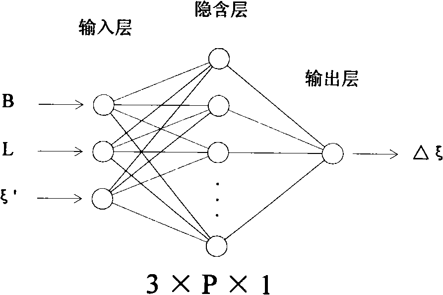
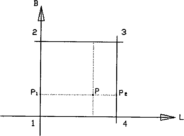
[0038] 1) Determine the scope of the area and arrange points. First determine the range of the region (generally determine the range of longitude and latitude); then, select a certain number of "measurement control points" in the region, the number of measurement control points (S) should depend on the size of the region, but S must be at least greater than equal to 10 and distributed evenly throughout the area.

[0039] 2) Field measurement (data collection). Two surveys, a GPS survey and a leveling survey, are required for survey control points in order to obtain relevant data.

[0040] (1) GPS measurement: In accordance with the requirements of the national measurement specification, conduct B-level or C-level GPS measurement for all control points, the purpose is to obtain the geodetic coordinates (latitude B, longitude L) and geodetic height (H G ).

[0041](2) Leveling survey: In accordance with the requirements of national surveying regulations, conduct second- or th...


PUM


Abstract

A method for precisely confirming the abnormality of a regional elevation is a method for precisely confirming the abnormality of the regional elevation by utilizing an NN technology and a grid technology which includes: 1) confirming the regional range and stationing; 2) measuring in the field (collecting data); 3) fitting a quadratic polynomial; 4) measuring an adjustment; 5) simulating and calculating the NN; 6) refining a model; 7) carrying out regional gridding; 8) internally inserting the elevation abnormality. The result precise by using the method for calculating the elevation abnormality is high, thus enlarging the application range of a GPS elevation measuring result. Analyzed by the application results of a plurality of engineering examples, the precise of the calculating result of the elevation abnormality by using the method of the invention is higher by 20 to 60 percent than that of fitting the quadratic polynomial; after the precise is improved, the GPS elevation can replace the leveling of lower grades, thereby reducing the traditional working load of measuring with high cost, high difficulty, long period and low grades to the lowest extent; the economic benefit is remarkable.

Description

technical field [0001] The invention is a method for accurately determining regional elevation anomalies by using neural network technology and grid technology, and belongs to the technical field of "geodesy" in the subject of "surveying and mapping science and technology". Background technique [0002] "Elevation anomaly" refers to the difference between the Earth's ellipsoid and the Earth's quasi-geoid; "area" refers to a portion of the Earth's surface. Determining regional elevation anomalies is a key task in geodesy, and it is also an engineering task of great practical value. It can be said that the determination of regional elevation anomalies is the establishment and maintenance of a national elevation reference frame in the current GPS positioning era. It has the same significance as the establishment of a national high-precision GPS positioning network or a traditional national elevation control network. Project geodetic infrastructure. [0003] At present, there ...

Claims


Application Information

Patent Timeline
IPC IPC(8): G01C5/00G06N3/06
Inventor 胡伍生沙月进
Owner SOUTHEAST UNIV
Why Eureka
Try Eureka