Electronic map data processing method

An electronic map and data processing technology, applied in the field of geographic information systems, can solve problems affecting calculation and analysis results, enlargement, etc., and achieve the effect of accurate map compression

Active Publication Date: 2009-07-22
NANJING LES INFORMATION TECH
View PDF0 Cites 22 Cited by
  • Summary
  • Abstract
  • Description
  • Claims
  • Application Information

AI Technical Summary

Problems solved by technology

According to the principle of the Douglas-Puke algorithm, it can be deduced that the polygon compression will inevitably lead to the amplification of this subtle distortion, and it will expand with the expansion of the compression tolerance, sometimes reaching the point where it affects the calculation and analysis results

Method used


Image

  • Electronic map data processing method
  • Electronic map data processing method
  • Electronic map data processing method

Examples


Embodiment 1

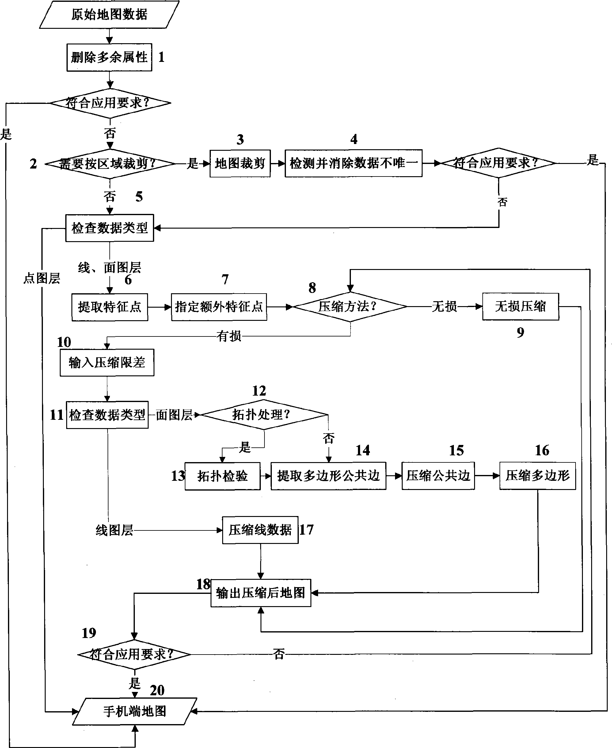
[0060] The following takes the Yancheng digital urban management map as an example to introduce the specific implementation. Since the present invention belongs to the invention of the software method, and has signed an intellectual property confidentiality agreement with the corresponding unit, the technical solution described in this patent application is still in a confidential state, which meets the requirements of novelty in the patent law.

[0061] From the perspective of administrative division, the digital urban management data of Yancheng includes Tinghu District and Yandu District, and the two districts also include 13 streets including Wuxing Street, Dayang Street, and Pioneer Street; 5 parts, urban geocoding, basic terrain and administrative divisions, among which urban management components include 76 layers of street lights, street trees, rainwater manhole covers, mailboxes, green spaces, public toilets, bulletin boards, etc., urban management includes 2 layers, u...


PUM


Abstract

The invention discloses a method used for mobile phone end map treatment, mainly comprising the following steps: superfluous attributes unused by a mobile phone end electronic map in original map data are deleted; the map clipping is carried out to realize the one-time selecting multi-region multi-layer clipping, and the condition that a plurality of geographic entities have the same mark in clipping results is automatically recognized and treated according to the requirements of users; the map compression is carried out, including lossless compression and loss compression, wherein, the lossless compression cannot influence the precision and the information amount of original maps, the loss compression realizes the maximum compression under the premise of losing part of the map precision, the users are supported to input compression tolerance to obtain maps which better accord with the practical application requirement; feature points on the map are automatically recognized and reserved, and the users are supported to appoint extra feature points; the loss compression adopts a strategy that common edges are compressed firstly and then the body of a polygon is compressed, therefore, the compression distortion phenomenon is avoided effectively; to the compression distortion caused by the original map data, the accuracy of the compressed data is guaranteed.

Description

technical field [0001] The invention relates to the technical field of geographic information systems, in particular to a method for processing electronic map data on a digital city management mobile phone terminal. Background technique [0002] In the process of modern information development, electronic maps have penetrated into all aspects of people's lives, especially electronic maps have also begun to be used in mobile phones. In the digital urban management application system, street patrols should use mobile phones to report problems after discovering urban management problems. The mobile phone terminal must be able to provide detailed information on the location of the incident (coordinates and standard addresses), and all urban management components should also be provided information and displayed on the map with a specific icon. The basic geographic information of the city in the map includes main roads, secondary roads, rivers, buildings and street ranges, respo...

Claims


Application Information

Patent Timeline
IPC IPC(8): G06F17/30G09B29/00
Inventor 吴伯军鲁士仿金岩李小云康杰伟郝建光
Owner NANJING LES INFORMATION TECH
Why Eureka
Try Eureka