3D landform rendering method and rendering apparatus

A terrain rendering and 3D technology, applied in the 3D field, can solve problems affecting rendering effects, 3D terrain jumping, etc., and achieve high rendering efficiency

Inactive Publication Date: 2009-07-29
BEIJING PIXEL SOFTWARE TECH
View PDF0 Cites 17 Cited by
  • Summary
  • Abstract
  • Description
  • Claims
  • Application Information

AI Technical Summary

Problems solved by technology

However, since the plane mesh model and vertex data corresponding to different LOD levels of the same terrain block are different, when the LOD level changes, the parameters such as vertex height, brightness, and chromaticity of the terrain

Method used


Image

  • 3D landform rendering method and rendering apparatus
  • 3D landform rendering method and rendering apparatus
  • 3D landform rendering method and rendering apparatus

Examples


Embodiment Construction

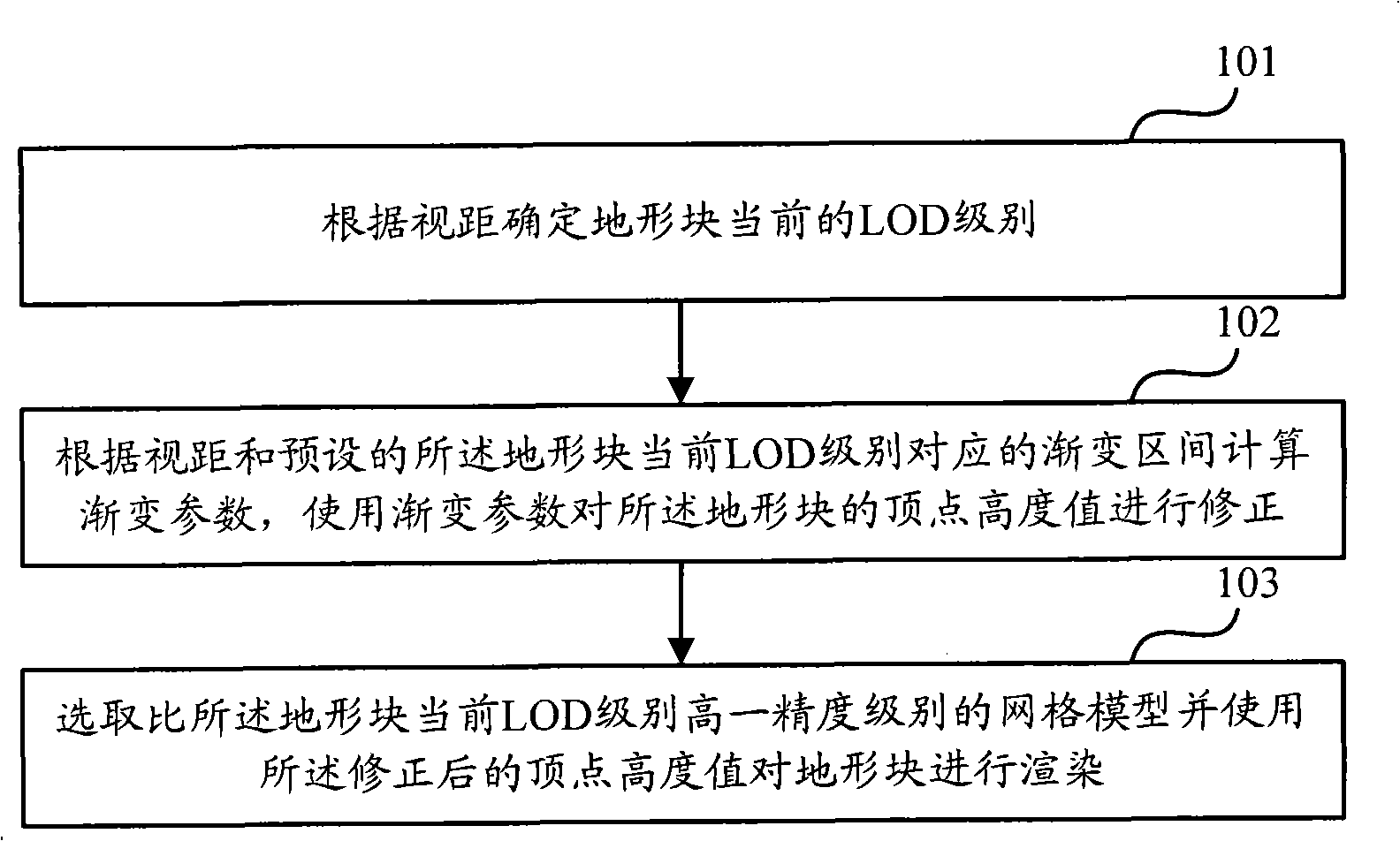
[0023] In order to make the object, technical solution and advantages of the present invention clearer, the present invention will be further described in detail below with reference to the accompanying drawings and examples.

[0024] The present invention mainly adopts the terrain block data corresponding to the LOD level higher than the current LOD level of the terrain block, and renders the terrain block in a continuous gradient manner, and uses a high-precision terrain block model to simulate a low-precision terrain block. When the shape of the high-precision terrain block and the low-precision terrain block are exactly the same, the LOD level of the terrain block becomes low-precision.

[0025] figure 1 It is a flowchart of a 3D terrain rendering method according to an embodiment of the present invention, such as figure 1 As shown, the process includes:

[0026] Step 101, determine the current LOD level of the terrain block according to the viewing distance.

[0027] A...


PUM


Abstract

The invention discloses a 3D terrain rendering method which comprises the following steps: the current level of detail (LOD) of a terrain block is determined in accordance with the viewing distance; the gradient parameter is calculated in accordance with the viewing distance and the preset gradient section which corresponds to the current LOD of the terrain block and the vertex height value of the terrain block is corrected with the gradient parameter; and a grid model which is one precision level higher than the current LOD of the terrain block is selected and the terrain block is rendered with the corrected vertex height value. The method and the device render the corrected terrain block data vary continuously in accordance with the variation of the view point; and even the LOD of the terrain block varies, no terrain 'jumping' phenomena appears. The invention discloses a 3D terrain rendering device simultaneously.

Description

technical field [0001] The present invention relates to the technical field of 3D (3D), in particular to a 3D terrain rendering method and a rendering device. Background technique [0002] 3D terrain rendering refers to performing operations such as coloring, vertex transformation, and mapping on 3D modeled terrain. In 3D terrain rendering, in order to reduce the processing burden of rendering, a level of detail (LOD, Level Of Detail) technology appears. The LOD technology divides terrain rendering into different levels of fineness. The terrain that is closer to the viewpoint (that is, the viewing distance is smaller) is rendered with higher details, and the terrain that is farther from the viewpoint (that is, the viewing distance is larger) is rendered with lower details. [0003] In 3D terrain rendering, the complete terrain is generally divided into small terrain blocks of equal size, and each terrain block is rendered according to its plane mesh model and vertex data. ...

Claims


Application Information

Patent Timeline
IPC IPC(8): G06T15/00
Inventor 龚静
Owner BEIJING PIXEL SOFTWARE TECH
Why Eureka
Try Eureka