Land slide sensitivity measuring method based on single land slide data

A measurement method and sensitivity technology, applied in the direction of measuring devices, geophysical measurement, instruments, etc., can solve the problems of low reliability, large data condition restrictions, troublesome operation, etc., to avoid human subjectivity and high reliability , the effect of easy operation

Inactive Publication Date: 2011-06-08
INFORMATION CENT LAND & RESOURCES OF ZHEJIANG PROVINCE
View PDF0 Cites 0 Cited by
  • Summary
  • Abstract
  • Description
  • Claims
  • Application Information

AI Technical Summary

Problems solved by technology

[0006] In order to overcome the deficiencies of the existing landslide sensitivity map production methods that are limited by data conditions, troublesome operation, long construction period, large investment, and low reliability, the present invention provides a fast, efficient, simple operation, less investment, and high reliability High landslide sensitivity measurement method based on single landslide data

Method used


Image

  • Land slide sensitivity measuring method based on single land slide data
  • Land slide sensitivity measuring method based on single land slide data
  • Land slide sensitivity measuring method based on single land slide data

Examples


Embodiment Construction

[0041] The present invention will be further described below in conjunction with the accompanying drawings.

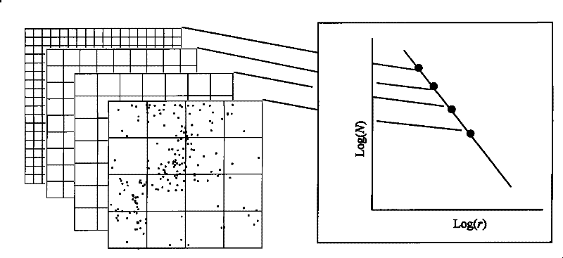
[0042] refer to figure 1 and figure 2 , a landslide sensitivity measurement method based on single landslide data, the landslide sensitivity measurement method comprises the following steps:

[0043] 1), use the existing landslide data with coordinate parameters to establish the spatial distribution function of the landslide, and compile the landslide distribution map;

[0044] 2) Consider the landslide as a point set in space, divide the entire work area into geometric units with a scale of r for statistics, and use the number box method to establish the spatial cluster distribution relationship of the landslide, that is, cover with geometric units with a scale of r In the study area, when the scale of the geometric unit changes, the number of units containing landslides N(r) and the scale of the geometric unit r are projected on the log-logarithmic coordinate map,...


PUM


Abstract

The present invention discloses a single landslide data-based method for measuring landslide sensitivity, which comprises the following steps: 1) creating a space distribution function of landslide by using a group of landslide data with geographic or measurement coordinate parameters and drawing up a landslide distribution map; 2) regarding the landslide as a point collection in space, dividing a whole work area into a plurality of geometric units of a dimension r for statistic, establishing a space cluster distribution relation of the landslide by using a box counting method, projecting the number N of grids containing the landslide and the dimension r of the geometric units onto a log-log plot when the size of the geometric units changes and obtaining the slope of a straight line by fitting data points; 3) calculating the percentage of the number of the grids containing the landslide when the dimension of the geometric units is ri in the total number of the grids containing the landslide under the geometric units of different dimensions; and 4) determining landslide degree dividing boundary values by using the buffer function of GIS and determining the landslide sensitivity. The method is quick and high in efficient, simple in operation, small in investment and high in reliability.

Description

technical field [0001] The invention relates to a method for measuring landslide sensitivity. Background technique [0002] Definition of landslides: The landslides mentioned here mainly refer to soil and rock sliding and debris flow caused by rainfall. This type of landslide has the highest frequency of occurrence among various landslides, the widest distribution area and the greatest harm. [0003] Landslide susceptibility measurement methods are mainly used to compile landslide susceptibility maps (Landslide susceptibility mapping, called landslide susceptibility maps in China, or preparation of landslide susceptibility zoning maps), to characterize the spatial distribution of potentially unstable slopes through landslide susceptibility maps, Used to prevent and mitigate landslide disaster losses. Landslide sensitivity maps of various scales (scales) are useful in two aspects: (1) When formulating regional economic and social development plans and environmental protectio...

Claims


Application Information

Patent Timeline
Patent Type & Authority Patents(China)
IPC IPC(8): G01V1/00G01V1/34
Inventor 李长江麻土华
Owner INFORMATION CENT LAND & RESOURCES OF ZHEJIANG PROVINCE
Why Eureka
Try Eureka