Sub-pixel spatial mapping method based on spatial correlation

A spatial correlation and spatial positioning technology, which is applied in the directions of electromagnetic wave re-radiation, measuring devices, instruments, etc., can solve the problems of slow speed and achieve the effect of simple calculation, strong interpretation and high algorithm efficiency

Active Publication Date: 2009-10-21
INST OF GEOGRAPHICAL SCI & NATURAL RESOURCE RES CAS
View PDF0 Cites 8 Cited by
  • Summary
  • Abstract
  • Description
  • Claims
  • Application Information

AI Technical Summary

Problems solved by technology

[0004] In the process of sub-pixel imaging, the above method not only relies on the original image, but also applies other relat

Method used


Image

  • Sub-pixel spatial mapping method based on spatial correlation
  • Sub-pixel spatial mapping method based on spatial correlation
  • Sub-pixel spatial mapping method based on spatial correlation

Examples


Embodiment Construction

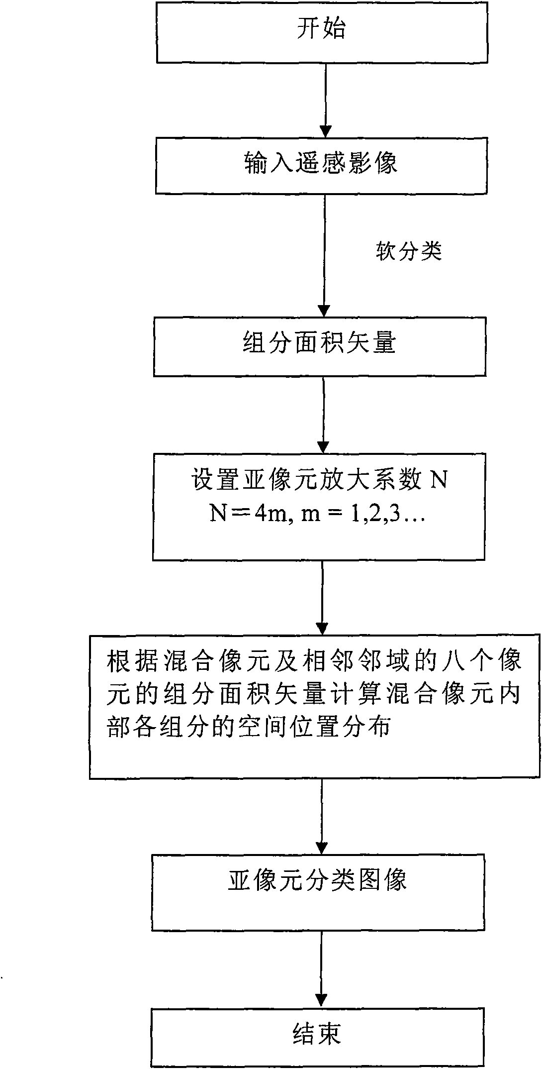
[0016] Such as figure 1 Shown, the specific implementation steps of the present invention are as follows:

[0017] Step 1. Preprocess the remote sensing data, collect sample points, and perform soft classification to obtain the soft classification information of each pixel on the processed image, that is, the area vector or abundance of the endmember components inside each pixel.

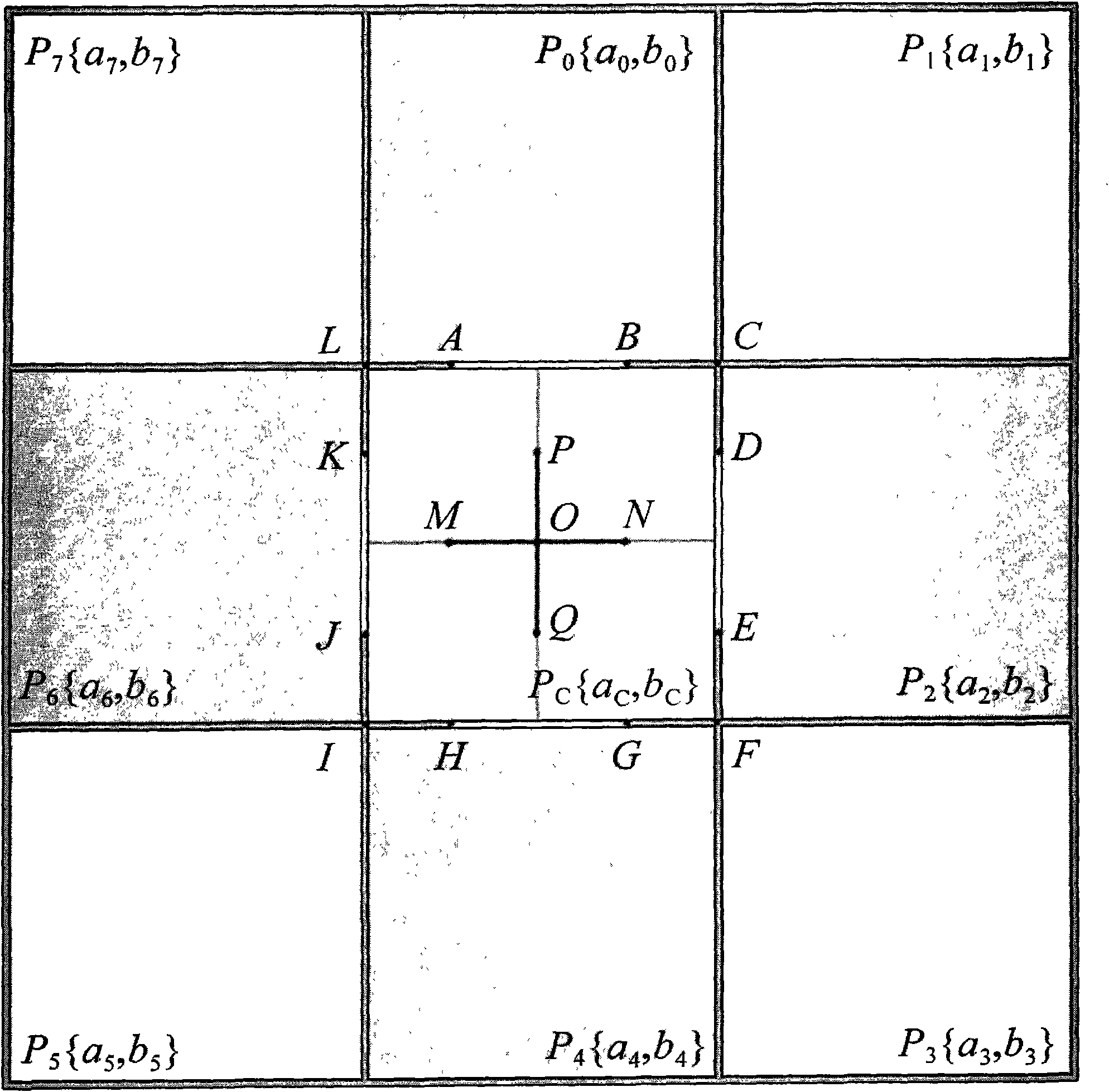
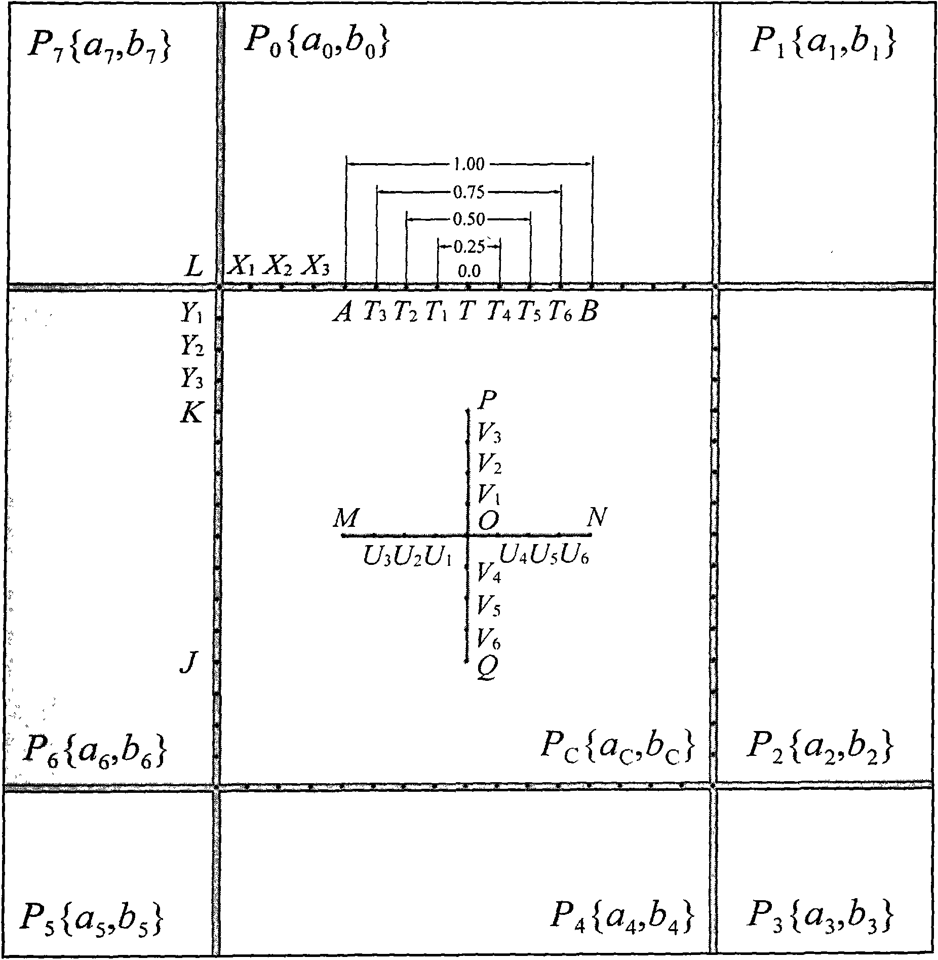
[0018] Assuming that a mixed pixel contains two component types A and B, when taking the first-order neighborhood, we can get figure 2 The central pixel P shown in C and its neighbor pixel P i The schematic diagram of the spatial distribution. Center pixel P C The area ratio of the two types of components in the interior is denoted as {a C , c C}, each neighborhood pixel P i The area ratio of the two component types in is denoted as {a i , b i}. The area ratio of each component inside the pixel satisfies the following conditions: a C +b C = 1; a i +b i =1, i=0, 1, . . . , N-1. Take t...


PUM


Abstract

The invention relates to a sub-pixel spatial mapping method based on spatial correlation, which comprises the step of calculating the spatial distribution of a basic component in pixels, namely sub-pixels by utilizing area vector or abundance ratio of mixed pixels and components (end members) of neighbor pixels of the mixed pixels so as to simulate a land feature boundary which is more detailed than that by a common remote sensing classification method. The method has the advantages of wide practicability, high analog simulation and the like, and is suitable for topographical information extraction and topographical data mining work such as target extraction by remote sensing data, monitoring of land resource utilization change, evaluation of environmental pollution, analysis of natural disasters and the like.

Description

technical field [0001] The invention relates to a spatial positioning method for components inside a sub-pixel, and belongs to the technical field of geospatial information. technical background [0002] Making thematic maps (image classification) using digital remote sensing images is a hot research field in remote sensing technology. However, due to the complexity of the surface, the influence of various environments in the process of spectral transmission, and the physical characteristics of the sensor detection element itself, the pixels in remote sensing images are rarely composed of a single object, and generally contain two or two or more features. This kind of pixel composed of multiple ground objects is called a mixed pixel, and its spectral characteristics are the comprehensive characteristics of the corresponding spectral responses of different land cover types. Mixed pixels are ubiquitous in raster-coded images, and they account for a large proportion, especial...

Claims


Application Information

Patent Timeline
IPC IPC(8): G06K9/80G01S17/89
Inventor 葛咏李三平
Owner INST OF GEOGRAPHICAL SCI & NATURAL RESOURCE RES CAS
Why Eureka
Try Eureka