Land parcel spatio-temporal data storage method based on dynamic correcting extension model of ground state

A dynamic correction, spatiotemporal data technology, applied in electrical digital data processing, special data processing applications, instruments, etc., to achieve the effect of improving efficiency and avoiding complexity and tediousness

Inactive Publication Date: 2009-12-02
ZHEJIANG UNIV
View PDF0 Cites 34 Cited by
  • Summary
  • Abstract
  • Description
  • Claims
  • Application Information

AI Technical Summary

Problems solved by technology

For example: for t 0 For querying and recovering the historical spatio-temporal relationship of time, direct K-point state correction has obvious advantages, because the result can be obtained only through one difference file operation; and for t 1 Indirect K-point status correction is obviously more beneficial, but more difference files need to be maintained

Method used


Image

  • Land parcel spatio-temporal data storage method based on dynamic correcting extension model of ground state
  • Land parcel spatio-temporal data storage method based on dynamic correcting extension model of ground state
  • Land parcel spatio-temporal data storage method based on dynamic correcting extension model of ground state

Examples


Embodiment

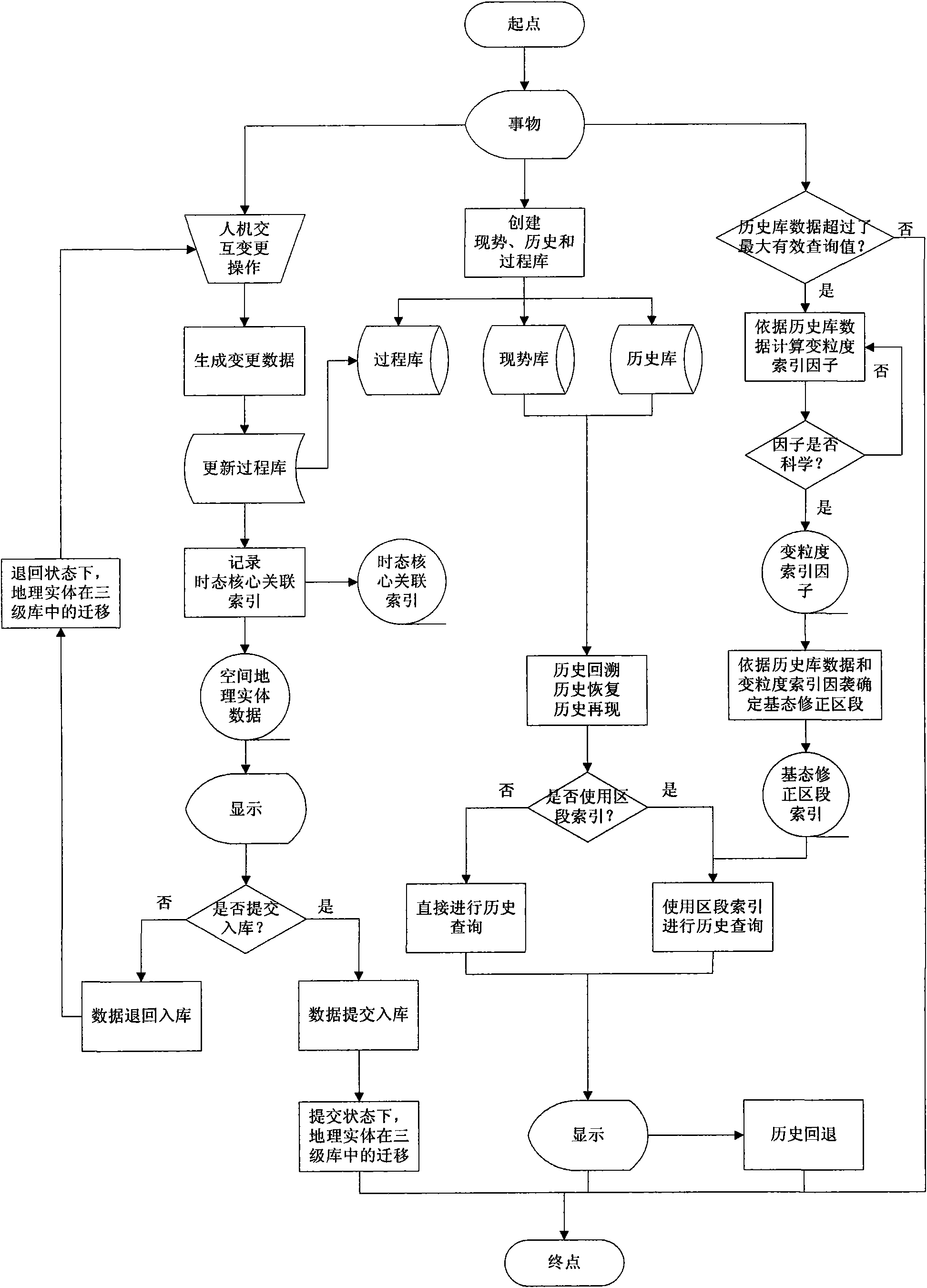
[0106] (1) Create current situation library, history library and process library

[0107] Examples of the current situation library, history library and process library in the embodiment "land property right property registration management information system" are as follows: Figure 14 shown. Among them, have The mark is a library node, and its child nodes are layer nodes, which are used to store similar geospatial entities (points, lines, and areas); the mark with "_LS" is the history library, and the mark "_WK" is the process library. Using geographic information system commercial software: ESRI’s ArcEngine COM component and ArcSDE geographic information system spatial database engine to create the current situation library, history library and process library and the VC++ codes of their layers are as follows:

[0108] / / Create a gallery (ipFeatWS is an IFeatureWorkspace interface variable passed in from outside)

[0109] IFeatureDatasetPtr ipCurFeatDataset; / / Current p...


PUM


Abstract

The invention discloses a land parcel spatio-temporal data storage method based on a dynamic correcting extension model of a ground state. The method comprises the following steps: based on the dynamic correcting extension model of the ground state, creating a present situation library, a process library and a history library, using a change tool to change a geographic space entity, simultaneously creating a temporal core associated index record change relation, and submitting changed data to the libraries; when the data in the history library exceed a maximum effective query threshold value, according to the best query value, creating variable granularity index factors and quick indexes of a ground state correcting zone; and according to the indexes, carrying out history recall, history recovery and regional history reproduction, and finally finishing land parcel spatio-temporal data storage. The method can accurately record the processes of land parcel history evolution, and can effectively manage the history time of spatial data, avoid complexity and fussiness of data record during land parcel change, improve the retrieval efficiency, ensure the requirement of quickly recalling land parcel data information at arbitrary historic moment, and ensure the requirement that the data at the same moment do not produce ambiguity.

Description

technical field [0001] The invention relates to the technical field of spatio-temporal data storage of GIS (Geographic Information System), in particular to a parcel spatio-temporal data storage method based on a dynamically corrected extension model of the base state. It is also applicable to the storage of other geospatial entities that need to record the evolution history. Background technique [0002] (1) Spatio-temporal data model [0003] The spatio-temporal data model is an extremely important basis for establishing a geographic information application system with temporal characteristics. An actual temporal GIS application system often needs to be able to simultaneously deal with attribute data, spatial data, and spatial and attribute relationships under time-varying states, as well as the process and trend of spatio-temporal changes. [0004] The base state amendment model (base state with amendment) corresponds to the continuous snapshot model. It is to prevent t...

Claims


Application Information

Patent Timeline
Patent Type & Authority Applications(China)
IPC IPC(8): G06F17/30
Inventor 刘南刘仁义张丰方雷杜震洪唐远彬
Owner ZHEJIANG UNIV
Why Eureka
Try Eureka