Radar remote sensing-based detection method of soil alkalization

A technology for remote sensing monitoring and salinization, which is applied in the field of radar remote sensing monitoring of soil salinization, and can solve problems such as difficulty in large-scale promotion, prolonged monitoring period, and inability to express dielectric characteristics.

Inactive Publication Date: 2009-12-30
REMOTE SENSING APPLIED INST CHINESE ACAD OF SCI
View PDF0 Cites 36 Cited by
  • Summary
  • Abstract
  • Description
  • Claims
  • Application Information

AI Technical Summary

Problems solved by technology

[0021] 1. Soil particle size data is required as prior basic data, which hinders the implementation of large-scale inversion of soil water content;
[0022] 2. The intermediate auxiliary parameters that need to be calculated in the second step are all based on empirical formulas, which have local applicability and are not easy to promote on a large scale;
[0023] 3. Insufficient consideration of the factors affecting the imaginary part of the complex dielectric constan

Method used


Image

  • Radar remote sensing-based detection method of soil alkalization
  • Radar remote sensing-based detection method of soil alkalization
  • Radar remote sensing-based detection method of soil alkalization

Examples


Embodiment Construction

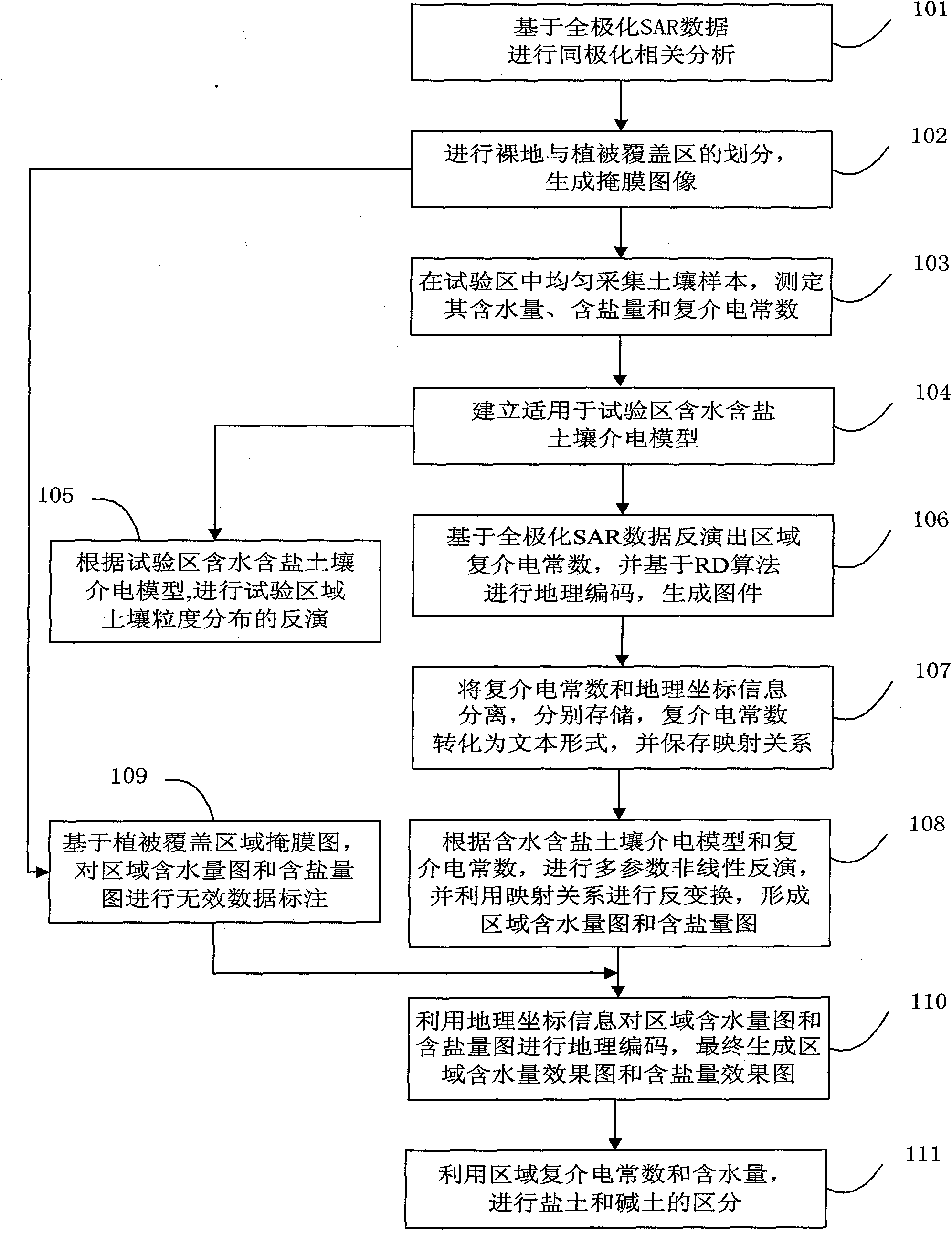
[0062] The technical solutions of the present invention will be further described below in conjunction with the accompanying drawings and through specific implementation methods.
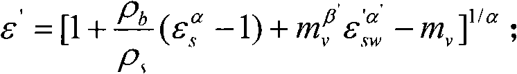
[0063] The main idea of ​​the technical solution of the present invention is to firstly carry out the co-polarization correlation analysis and the calculation of the polarization degree based on the full polarization SAR data, and carry out the division of the bare land (including the low vegetation coverage area) and the vegetation coverage area according to the polarization parameters, Generate a mask image; secondly, delineate the test area according to the mask image of bare land (including low vegetation coverage area), and use the measurement data of several sample points to establish the dielectric model of water-containing and saline soil; and then use SAR full polarization data to invert The complex permittivity map of the test area and the corresponding distance-Doppler (Range-Doppler, RD) ...


PUM


Abstract

The invention discloses a radar remote sensing-based detection method of soil alkalization, comprising the following steps: computing the polarization parameter based on full polarimetric SAR data, dividing bare areas and vegetation-covered areas and generating images with masks; delimiting test areas and adopting measuring data to establish a dielectric model of moist salt soil; adopting the full polarimetric SAR data to invert a complex permittivity map and carrying out RD geocoding, data information separation and conversion; based on the dielectric model and the complex permittivity, adopting the genetic algorithm for inversion to obtain moisture contents and salt contents of areas, and integrating geographic coordinate information and a vegetation cover mask map to generate a moisture content map and a salt content map; adopting the complex permittivity and the moisture contents of areas to differentiate saline soil from alkali soil. By adopting the technical proposal of the invention, the moisture content and the salt content of the soil in saline areas can be obtained, the degree of dependence on ground assistant data is reduced and simultaneously the dielectric behavior of the moist salt soil can be better depicted.

Description

technical field [0001] The invention relates to the technical field of microwave remote sensing applications, in particular to a radar remote sensing monitoring method for soil salinization. Background technique [0002] Microwave remote sensing technology is a relatively young subject, and my country's research in this field started in the 1970s. The research work has developed from the qualitative analysis of single-band, single-polarization airborne Synthetic Aperture Radar (SAR) data in the past to the quantitative analysis of multi-band, multi-polarization, and multi-mode spaceborne SAR data at the present stage. With the launch of high-resolution full-polarization SAR satellites, microwave remote sensing technology will enter a new development period, both theoretically and technically, which requires a lot of basic research. At present, soil salinization is a serious problem in the world, and it is extremely important to strengthen the monitoring of soil salinization...

Claims


Application Information

Patent Timeline
IPC IPC(8): G01S13/90G01S7/02
Inventor 邵芸宫华泽蔡爱民谢酬王国军
Owner REMOTE SENSING APPLIED INST CHINESE ACAD OF SCI
Why Eureka
Try Eureka