Mobile robot visual navigation method based on colorful road signs

A mobile robot and robot vision technology, which is applied in the field of visual navigation of mobile robots, can solve the problems of low robustness of natural road signs and high image processing time complexity, and achieves low image processing complexity, high robustness and artificial intelligence. road sign simple effect

Active Publication Date: 2013-02-20
CHONGQING UNIV OF POSTS & TELECOMM
View PDF2 Cites 0 Cited by
  • Summary
  • Abstract
  • Description
  • Claims
  • Application Information

AI Technical Summary

Problems solved by technology

[0008] Aiming at the disadvantages of low robustness of natural landmarks and high time complexity of image processing in the visual navigation of mobile robots, the present invention proposes a method for visual navigation of mobile robots based on color landmarks

Method used


Image

  • Mobile robot visual navigation method based on colorful road signs
  • Mobile robot visual navigation method based on colorful road signs
  • Mobile robot visual navigation method based on colorful road signs

Examples


Embodiment Construction

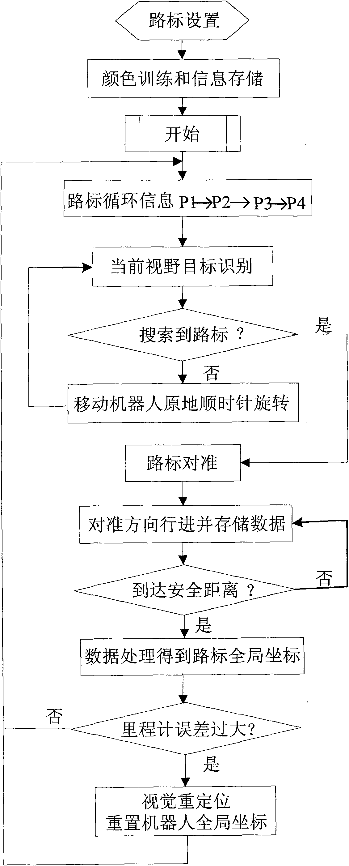
[0022] The present invention designs a mobile robot visual navigation method based on color road signs. When the mobile robot starts to move, the default coordinate system is established with the initial traveling direction as the X axis. This coordinate system is called the robot coordinate system, also known as the local coordinate system. Inertial devices such as the odometer in the robot can obtain the position coordinates of the mobile robot in the local coordinate system at each moment. Of course, the global coordinates of the mobile robot can also be obtained through coordinate rotation and translation. The coordinates of the odometer are relatively accurate in a short period of time, but as the time increases due to factors such as the slippage of the mobile robot wheels and uneven road surfaces, the accumulation of coordinate errors will continue to increase, and the coordinates of the mobile robot will appear different from The deviation from the actual situation beco...


PUM


Abstract

The invention provides a mobile robot visual navigation method based on colorful road signs, relating to the intelligent control field. Two cylinders with different color rings are designed as the road signs of mobile robot visual navigation in the invention; the partition of the colorful road signs is effectively achieved under the color space of (HIS: Hue, Saturation, Intensity) and in combination of a threshold partitioning method in which H is taken as a main threshold value and I is taken as an auxiliary threshold valve and a partitioning method based on the quantity statistic of S component edge points; and the identification of a robot to the road signs and an aligning technology are achieved through the image information of the color rings. The vertical distance value at the center of the two color rings is optimized through introducing a relevant gray matching method. The world coordinate of the road signs is obtained through establishing a robot coordinate system and the imaging models of the road signs and is finally optimized through intruding the particle swarm optimization. The robot vision reposition based on the road signs is finished through establishing mathematical models.

Description

technical field [0001] The invention relates to the field of intelligent control, in particular to a visual navigation method for a mobile robot. Background technique [0002] Since the first industrial robot was invented in the early 1960s, robots have been developed for more than half a century, and the application of robots has become more and more extensive, penetrating into almost all fields. Robots have roughly evolved through three generations: the first generation is a programmable teaching and reproduction robot; the second generation is an off-line programming robot with certain sensory functions and adaptive capabilities; the third generation robot is an intelligent robot. Robots are developing towards the trend of intelligence and visualization. Intelligent and visual machine systems will be engaged in some operations in harsh environments where traditional machine systems and humans are incompetent. [0003] Mobile robot is an important branch of robotics. It i...

Claims


Application Information

Patent Timeline
Patent Type & Authority Patents(China)
IPC IPC(8): G01C21/26G01C21/34
Inventor 罗元张毅胡章芳王巍李玲张百胜
Owner CHONGQING UNIV OF POSTS & TELECOMM
Why Eureka
Try Eureka