'Three-map method' for evaluating ground fissures

A technology of ground fissures and evaluation indicators, applied in seismology, geophysical measurement, measuring devices, etc., can solve the problems of immature evaluation methods of geological disasters, great differences in results, and inability to comprehensively and quantitatively evaluate the hazards of geological disasters. To achieve the effect of improving the level of disaster management

Inactive Publication Date: 2010-06-09
CHINA UNIV OF MINING & TECH (BEIJING)
View PDF0 Cites 24 Cited by
  • Summary
  • Abstract
  • Description
  • Claims
  • Application Information

AI Technical Summary

Problems solved by technology

In the past, only a single factor was considered in the quantitative description and prediction of ground fissures, but in recent years, the multi-factor impact research on ground fissures mainly adopts linear methods, and it is impossible to analyze the relationship between various factors that affect ground fissures. Accurate description, let alone guarantee the reliability of its forecast results
[0011] 3. In terms of geological hazard assessment, although some assessments of the risk of geological hazards and the vulnerability of disaster-affected areas have been carried out independently, they are mainly qualitative or semi-quantitative assessments, which cannot fully reflect the natural and social attributes of disasters. It is impossible to comprehensively and quantitatively evaluate the harm caused by geological disasters to the human living environment based on the evaluation results of th

Method used


Image

  • 'Three-map method' for evaluating ground fissures
  • 'Three-map method' for evaluating ground fissures
  • 'Three-map method' for evaluating ground fissures

Examples


Embodiment 1

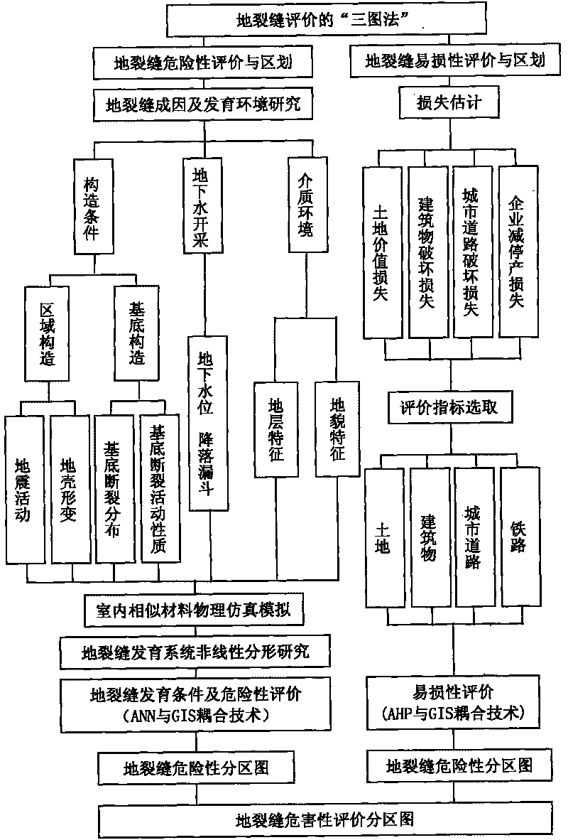
[0062] Refer to attached figure 1 , the concrete implementation technical scheme of " three graph method " of a kind of ground fissure evaluation of the present invention comprises the following steps:

[0063] 1. Carry out ground fissure risk assessment and division, and form a ground fissure risk division map;

[0064] Risk assessment is the embodiment of the natural attributes of geological hazards. Therefore, in order to evaluate the risk of ground fissures, it is first necessary to study the causes and development environment of ground fissures, analyze qualitatively and propose a conceptual model of the formation mechanism of ground fissures.

[0065] The research on the causes and development environment of ground fissures includes research on the structural conditions of the disaster-affected area, groundwater exploitation, and medium environment.

[0066] The research on structural conditions mentioned above includes the research on regional structure and basement s...

Embodiment 2

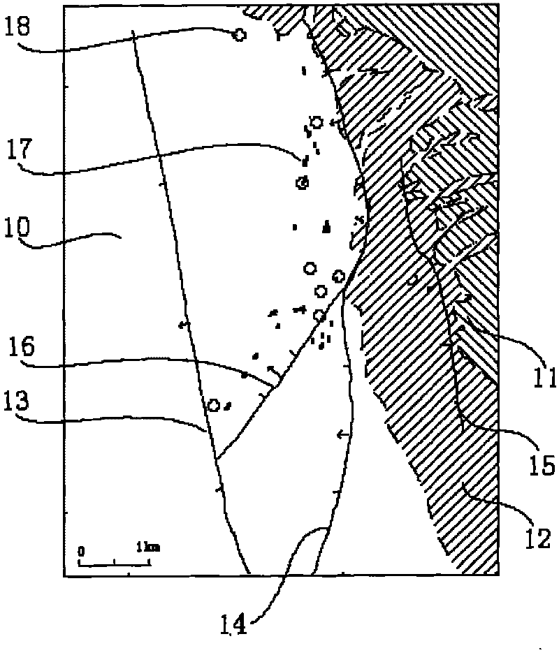
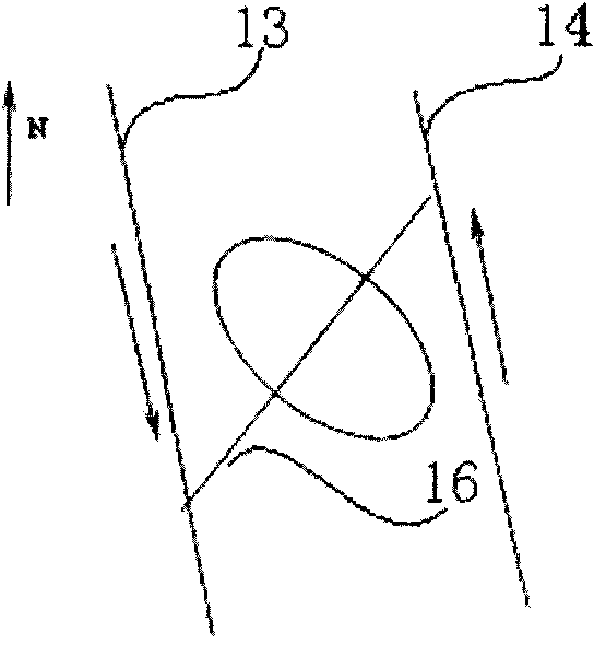
[0101] Refer to attached Figure 2-7 , take a ground fissure as an example below to discuss in detail the specific implementation technology of the "three-map method" of the ground fissure evaluation of the present invention:

[0102] 1. Carry out ground fissure risk assessment and division, and form a ground fissure risk division map;

[0103] First of all, it is necessary to conduct research on the cause of ground fissures and their development environment, qualitatively analyze and propose a conceptual model of the mechanism of ground fissures.

[0104] The research on the causes and development environment of ground fissures includes research on the structural conditions of the disaster-affected area, groundwater exploitation, and medium environment.

[0105] The site is located at the edge of the fault basin 10, and to the west and northwest are the first-level tableland 11 and the second-order tableland 12, so the main feature of the geological structure in the area is ...


PUM


Abstract

The invention relates to a 'three-map method' for evaluating ground fissures, comprising the following steps of: firstly, evaluating and zoning ground fissure risk to form a ground fissure risk zoning map, then evaluating and zoning ground fissure vulnerability to form a ground fissure vulnerability zoning map and finally evaluating and zoning ground fissure hazardness to form a ground fissure hazardness zoning map. The three-map method overcomes the defects that the prior art can not sufficiently reflect the natural and social attributes of disasters and can not comprehensively quantitatively evaluate ground fissure disasters, defines the concept of the geological disaster hazardness for the first time and puts forwards the viewpoint of evaluating the geological disaster hazardness for the first time. The invention provides an indoor similar material physical simulation analog test method for the cause of formation of the ground fissures, researches the structure characteristics and the fractional characteristics of the ground fissures and structure, physiognomy and earthquakes with the nonlinear idea for the first time and applies an artificial neural network (ANN) and geographic information system (GIS) coupling technique to evaluating the ground fissure risk.

Description

Technical field [0001] The invention relates to a method for evaluating geological hazards, in particular to a "three-map method" for evaluating geological hazards of ground fissures. Background technique [0002] Ground fissure is a supergene geological disaster phenomenon caused by internal and external forces and human activities. Compared with the fault structure in geological history, it is a structural fault activity that people can directly observe. It is common in many countries, and its frequency and scale of disasters are increasing year by year, and it has become a major type of regional geological disasters. The study of them can reverse the activity track of old structures in geological history, and contribute to reducing the loss of people's lives and property, which has important theoretical significance and practical value. my country's regional ground fissure disasters are quite serious, and there are reports of damage caused by them in 13 provinces includi...

Claims


Application Information

Patent Timeline
IPC IPC(8): G01V1/00
Inventor 武强
Owner CHINA UNIV OF MINING & TECH (BEIJING)
Why Eureka
Try Eureka