Poly GPS/INS and transportation image fusion and positioning method

A technology of image fusion and positioning method, applied in traffic control system, road vehicle traffic control system, instrument, etc., can solve the problem of poor positioning accuracy of vehicles

Inactive Publication Date: 2010-06-16
NORTHWESTERN POLYTECHNICAL UNIV
View PDF0 Cites 9 Cited by
  • Summary
  • Abstract
  • Description
  • Claims
  • Application Information

AI Technical Summary

Problems solved by technology

[0005] In order to overcome the shortcomings of the prior art fusion positioning method relying on measurement data and resulting in poor vehicle positioning accuracy, the present invention proposes a multi-GPS/INS and traffic image fusion positioning method, combining GPS...

Method used


Image

  • Poly GPS/INS and transportation image fusion and positioning method
  • Poly GPS/INS and transportation image fusion and positioning method
  • Poly GPS/INS and transportation image fusion and positioning method

Examples


Embodiment Construction

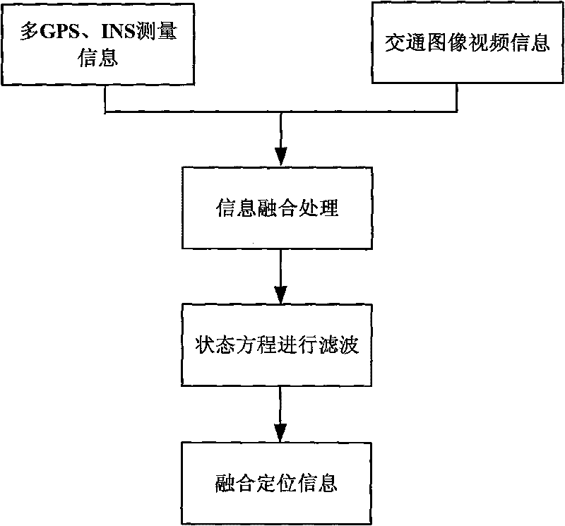
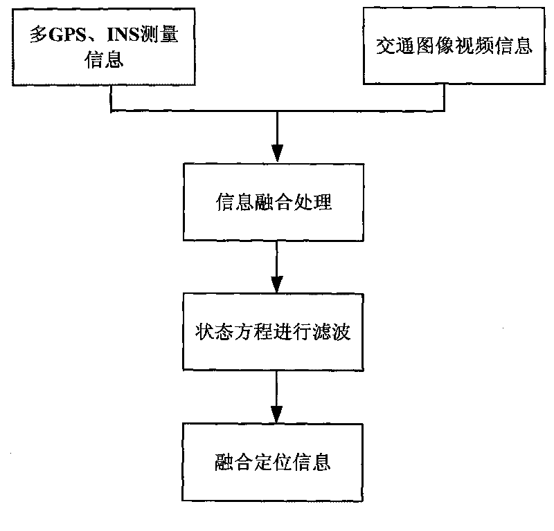
[0033] The fusion positioning method proposed by the present invention mainly includes the following steps: selection of state equation and observation equation, fusion estimation method under different noises, online elimination of errors and precise positioning.

[0034] 1. Selection of state equation and observation equation

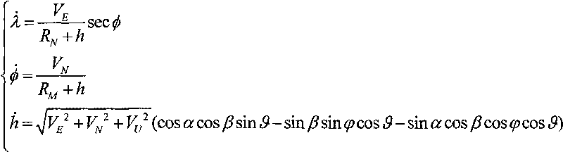
[0035] Since GPS and INS measurements can obtain the longitude, latitude, height and speed of the vehicle in different directions, the state equation is selected as follows:

[0036]

[0037] Among them, λ, φ, h are longitude, latitude and height respectively, V E , V N , V U is the speed of east, north and sky measured by GPS, is the radius of curvature of the meridian, is the radius of curvature of the Maoyou circle; R e is the semi-major axis of the earth, and ε is the eccentricity.

[0038] Since the measured parameters are different for different measuring devices, it is necessary to perform equivalent processing on the measured values...


PUM


Abstract

The invention discloses a poly GPS/INS and a transportation image fusion and positioning method applied to accurately position vehicles, belonging to the technical field of information fusion technology and intelligent information processing. In the invention, the poly GPS/INS and transportation image video and other traffic information are combined and fusion processing is carried out on such traffic information to obtain equivalent measured value; filtering is carried out by introducing state equations of the system; finally accurate vehicle positioning information is obtained. When datum mark information is collected by the image, the measured value of the datum mark is directly marked; so that system error returns to zero, thus improving positioning accuracy while supplementing some information on special road sections (such as the tunnel) by means of estimation.

Description

technical field [0001] The invention relates to a fusion positioning method, in particular to a fusion positioning method of multiple GPS and INS measurement information and traffic image information, and belongs to the technical field of intelligent information processing. Background technique [0002] With the rapid development of sensor technology and the emergence of a large number of multi-sensor systems, there are more and more various information data in system engineering. How to complete the comprehensive processing of multiple measurement data has become the focus of attention. Information fusion technology emerges as the times require. By collecting and integrating various information sources, multimedia and multi-format information, and on the basis of comprehensive information processing technology, complete, accurate, timely and effective comprehensive information is generated to obtain information on the same thing or target. A more objective and essential und...

Claims


Application Information

Patent Timeline
IPC IPC(8): G08G1/123G08G1/017
Inventor 史忠科王慧丽
Owner NORTHWESTERN POLYTECHNICAL UNIV
Why Eureka
Try Eureka