SINS/CNS deep integrated navigation system and realization method thereof

An integrated navigation and navigation solution technology, applied in the field of integrated navigation, can solve problems such as the inability to achieve a full range of applications, and achieve the effect of eliminating correlation, high-precision positioning and navigation, and improving accuracy.

Inactive Publication Date: 2010-07-28
BEIHANG UNIV
View PDF0 Cites 62 Cited by
  • Summary
  • Abstract
  • Description
  • Claims
  • Application Information

AI Technical Summary

Problems solved by technology

This astronomical / inertial optimal combination mode can not only compensate the random drift of the gyroscope, but also compensate the errors caused by other factors such as the accelerometer, but at present, this method can only be used on high-altitude flying objects above 30km, and cannot be used in a full range

Method used


Image

  • SINS/CNS deep integrated navigation system and realization method thereof
  • SINS/CNS deep integrated navigation system and realization method thereof
  • SINS/CNS deep integrated navigation system and realization method thereof

Examples


Embodiment Construction

[0038] The present invention will be further described in detail with reference to the accompanying drawings and embodiments.

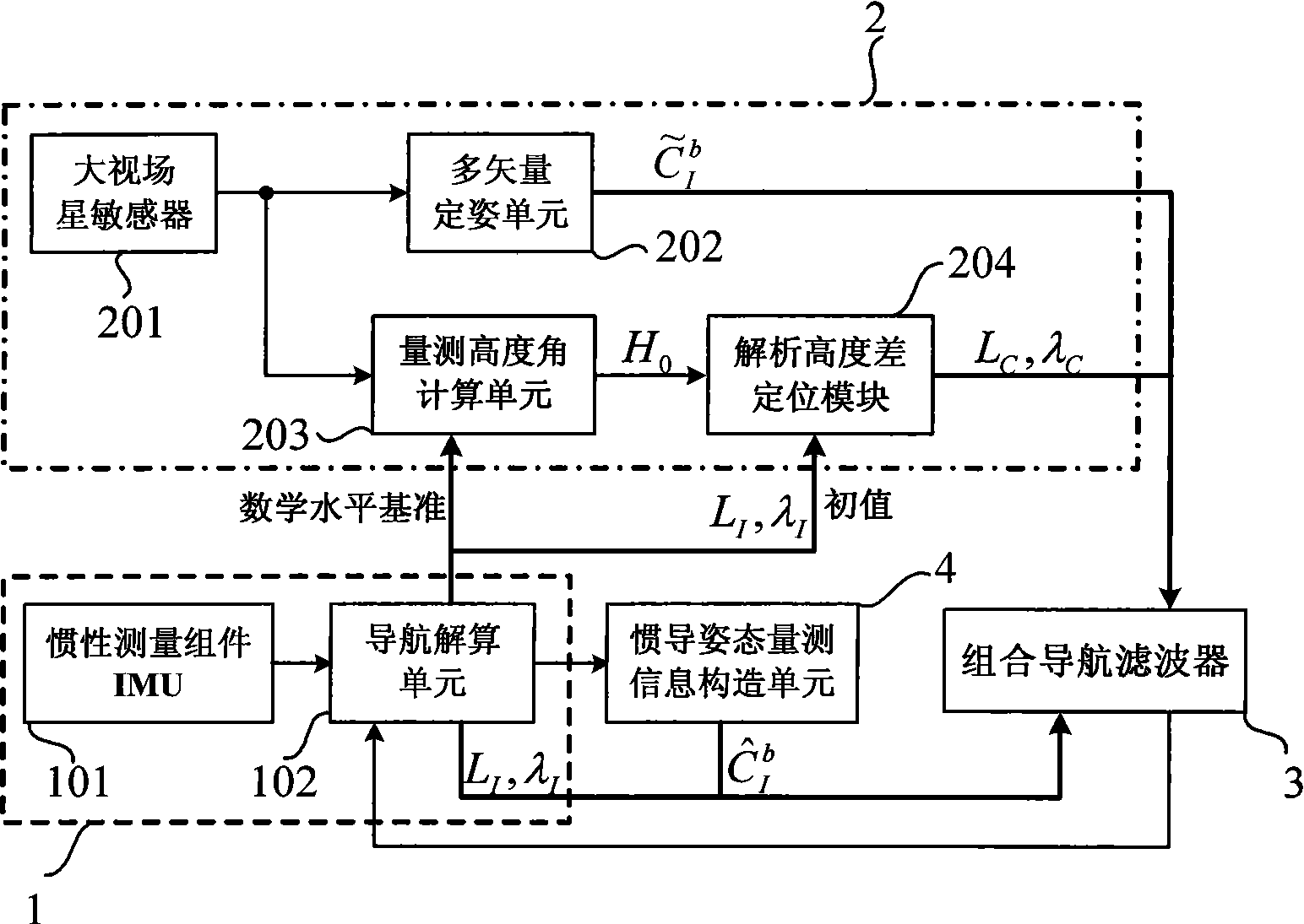
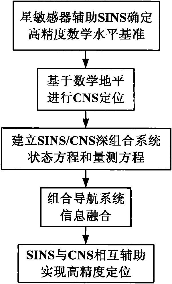
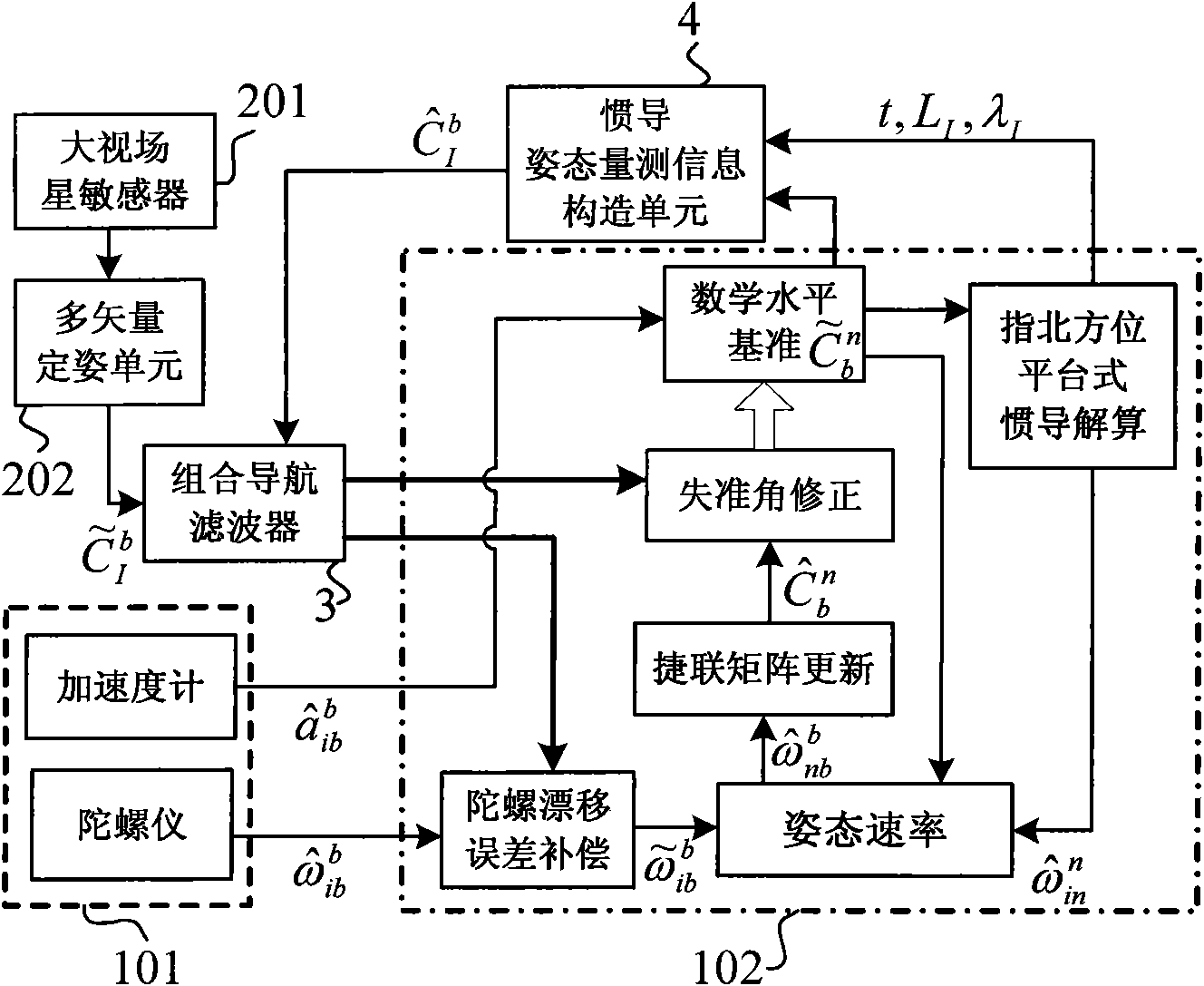
[0039] A kind of SINS / CNS deep integrated navigation system of the present invention, as figure 1 As shown, it includes a strapdown inertial navigation system 1, a celestial navigation system 2, an integrated navigation filter 3, and an inertial navigation attitude measurement information construction unit 4;

[0040] A strapdown inertial navigation system (SINS) 1 includes an inertial measurement unit (IMU) 101 and a navigation solving unit 102 . The inertial measurement unit 101 (IMU) measures the angular velocity and specific force of the carrier relative to the inertial space, and transmits the obtained carrier angular velocity and specific force information to the navigation calculation unit 102, and the navigation calculation unit 102 is based on the information transmitted by the inertial measurement unit 101. Real-time calculation of the posi...


PUM


Abstract

The invention discloses a SINS/CNS deep integrated navigation system and a realization method thereof. Wherein the navigation system comprises a strapdown inertial navigation system (SINS), a celestial navigation system (CNS), an integrated navigation filter, a inertial navigation posture measurement information structure unit; the realization unit comprises the following steps: 1. a large viewing field star sensor assists the strapdown inertial navigation system to obtain a high-precision mathematic horizontal reference; 2. CNS positioning is carried out based on the mathematic horizontal reference; 3. SINS/CNS deep integrated system model and measurement mode are established; 4. integrated navigation system information is fused; 5. the SINS and the CNS assists each other to realize high-precision positioning. In the invention, the star sensor high-precision posture information is employed to assist SINS to obtain high-precision SINS strapdown matrix which serves as the mathematic horizontal reference for CNS positioning, and on the basis, positions and postures of the CNS are employed to comprehensively calibrate the SINS, thus realizing SINS/CNS deep integration and finally achieving high-precision positioning and navigation.

Description

technical field [0001] The invention relates to a SINS / CNS deep integrated navigation system and a realization method thereof, belonging to the technical field of integrated navigation. Background technique [0002] The celestial navigation system (CNS) has good concealment, strong autonomy, and can provide carrier position and high-precision attitude information, but the output information is discontinuous, and in some cases will be affected by the external environment, and it is difficult to use it alone. Meet the high-precision, high-performance navigation and positioning requirements. [0003] The positioning accuracy of the traditional celestial navigation system mainly depends on the accuracy of the horizontal reference and the measurement accuracy of the celestial sensor. Since the current astronomical sensors can easily achieve the astronomical accuracy of 1 arc second, the accuracy of the horizon has become the most important factor affecting the accuracy of astron...

Claims


Application Information

Patent Timeline
Patent Type & Authority Applications(China)
IPC IPC(8): G01C21/02G01C21/16G01C21/20
Inventor 王新龙吴小娟
Owner BEIHANG UNIV
Why Eureka
Try Eureka