Land degradation response unit-oriented high-spectrum land degradation information extracting method

A technology for land degradation and information extraction, which is applied to radio wave measurement systems, instruments, etc., to achieve the effect of rapid acquisition

Inactive Publication Date: 2010-07-28
中国土地勘测规划院
View PDF5 Cites 12 Cited by
  • Summary
  • Abstract
  • Description
  • Claims
  • Application Information

AI Technical Summary

Problems solved by technology

[0004] In the existing technology, due to the limitations of technical methods and means, there is still a lack of technology and methods for rapid acquisition of land degradation information

Method used


Image

  • Land degradation response unit-oriented high-spectrum land degradation information extracting method
  • Land degradation response unit-oriented high-spectrum land degradation information extracting method

Examples


Embodiment Construction

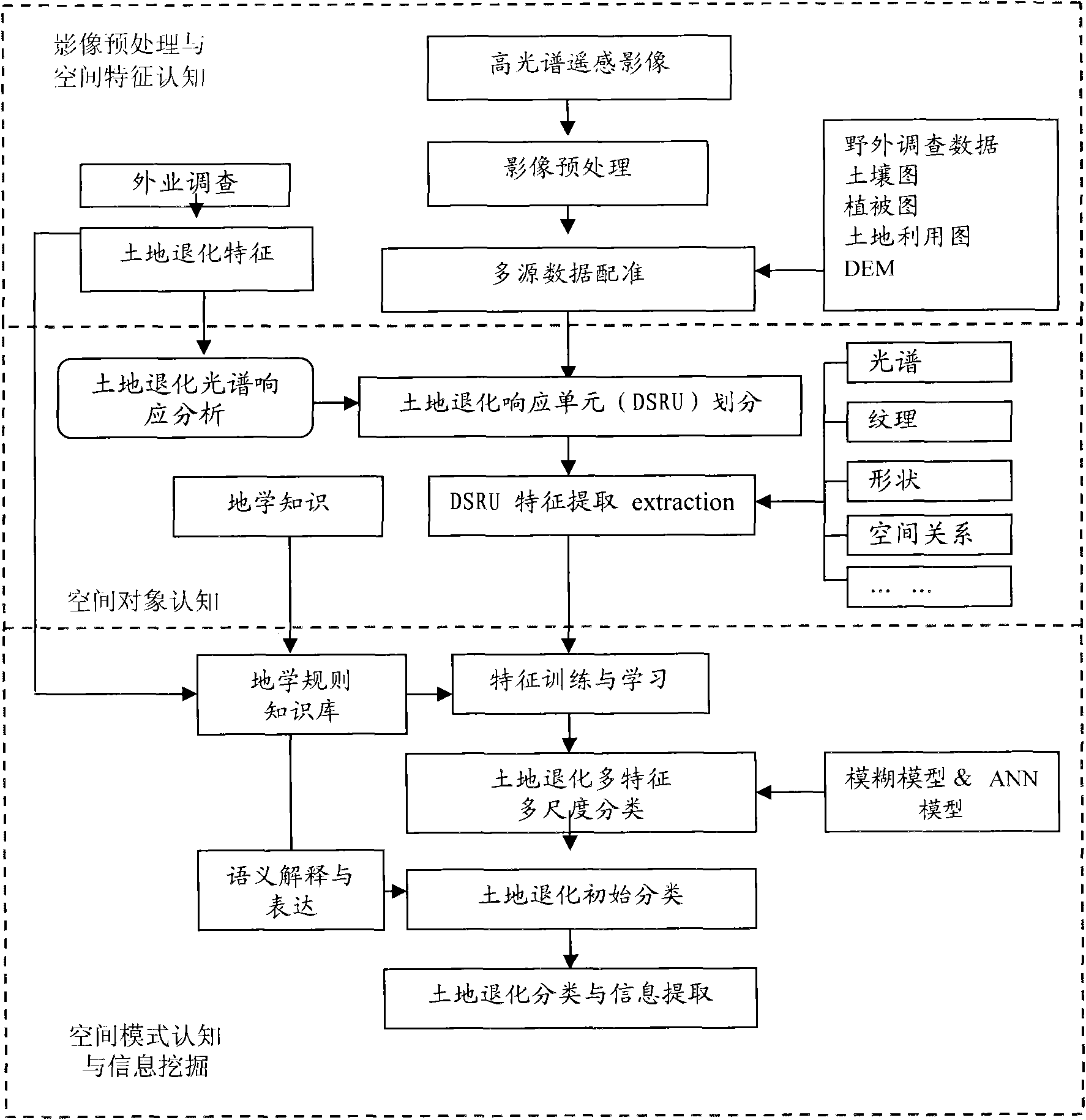
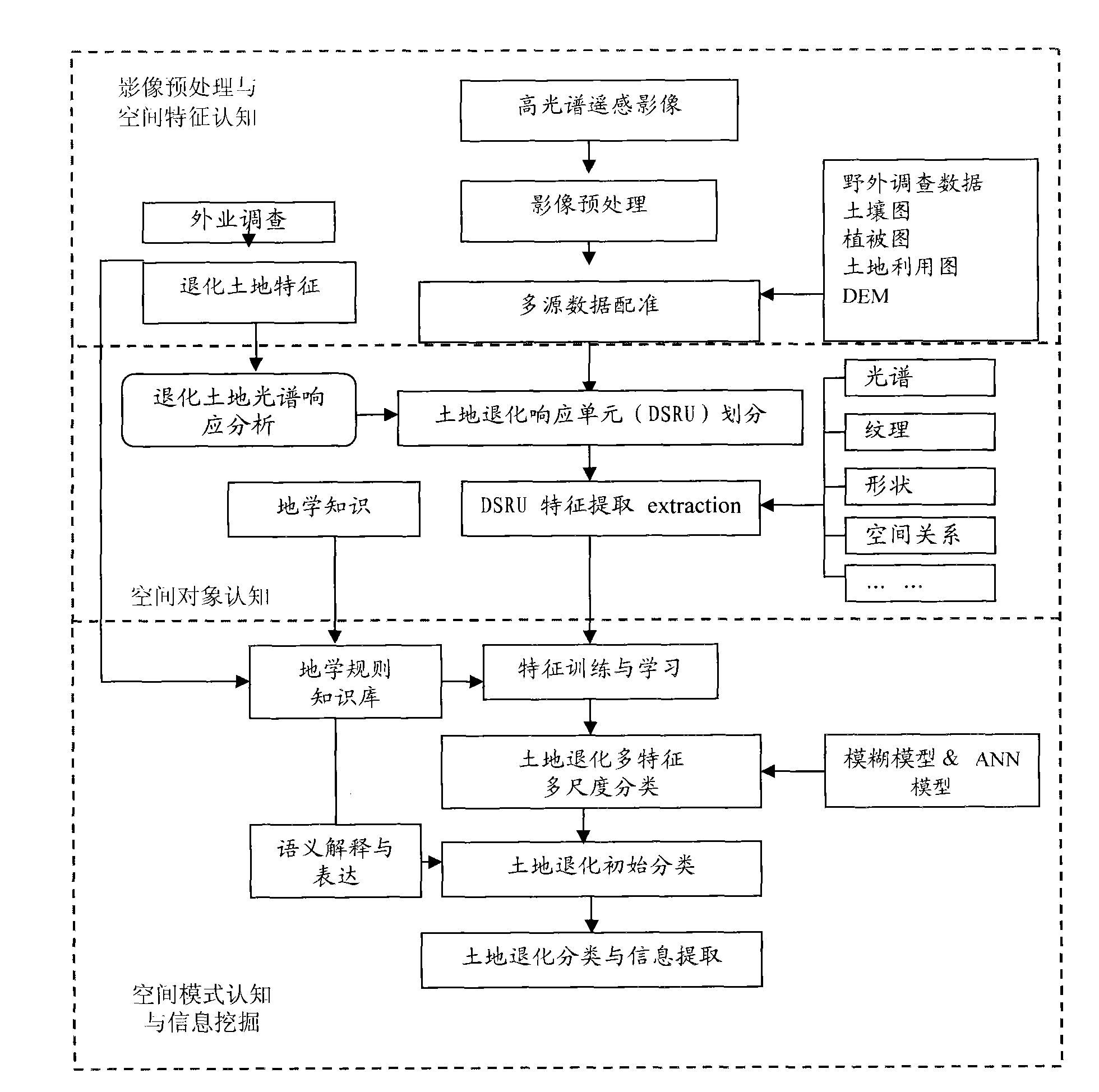
[0014] The hyperspectral land degradation information extraction method oriented to the land degradation response unit of the present invention, its preferred specific implementation is shown in Figure 1:

[0015] Including the following processes:

[0016] Image preprocessing and feature recognition process, spatial object recognition process, and spatial pattern recognition and information mining process;

[0017] The process of image preprocessing and spatial feature recognition includes band selection, calibration, atmospheric correction, geometric correction, denoising, mosaic of hyperspectral remote sensing data, and the integration of soil maps, vegetation maps, land use maps, basic geographic Multi-source data registration and other remote sensing image preprocessing processes are carried out on information and field survey information; at the same time, combined with field survey data, the characteristics of degraded land and the spectral response of degraded land are...


PUM


Abstract

The invention discloses a land degradation response unit-oriented high-spectrum land degradation information extracting method, which comprises three processes of image pre-processing and spatial characteristic cognition, spatial object cognition, and spatial mode cognition and information mining. The method comprises the following steps: pre-treating a high-spectrum image; integrating multi-source data of high-spectrum remote sensing image, soil, vegetation, basic geographic information, geoscience knowledge, field survey information and the like to divide a land degradation response unit based on degraded land spectrum characteristic analysis and spectrum response analysis; synthesizing information of spectrum, texture, shape, spatial relationship and the like to extract the characteristics of the land degradation response unit; and performing multi-dimensional classification of land degradation types by adopting a land degradation response unit-oriented image analyzing method based on a fuzzy model and an ANN model under the guidance of a geographic knowledge base and a rule base so as to evaluate the land degradation and extract the land degradation information. The method solves the problem that an evaluation unit in the traditional land degradation remote sensing monitoring and evaluating method is difficult to determine, and can quickly acquire the land degradation information.

Description

technical field [0001] The invention relates to a technology for extracting land degradation information, in particular to a hyperspectral land degradation information extraction method for land degradation response units. Background technique [0002] The land issue is a strategic issue closely related to the national economy and people's livelihood, social stability and national security. In areas where the ecological environment is relatively fragile and disturbed by human activities, the contradiction between man and land has intensified, leading to serious land degradation, especially the quality of high-quality cultivated land. , affecting the sustainable development of the environment and social economy. [0003] At present, land resources management has developed from quantitative management to quality management and ecological management. Land dynamic monitoring will develop from the previous single land quantity monitoring to land quality monitoring and ecological...

Claims


Application Information

Patent Timeline
Patent Type & Authority Applications(China)
IPC IPC(8): G01S7/48
Inventor 王静何挺刘爱霞吕春艳
Owner 中国土地勘测规划院
Why Eureka
Try Eureka