Method for performing inter-conversion between survey coordinates and construction coordinates

A technology for measuring coordinates and construction coordinates, applied in the field of mutual conversion, can solve problems such as adverse effects on data accuracy and heavy calculation workload, and achieve the effects of intuitive relative relationship, convenient use, and improved data accuracy.

Inactive Publication Date: 2010-09-08
CHINA FIRST METALLURGICAL GROUP
View PDF1 Cites 17 Cited by
  • Summary
  • Abstract
  • Description
  • Claims
  • Application Information

AI Technical Summary

Problems solved by technology

[0002] The traditional building positioning measurement method is: directly use the measurement coordinates provided by the design institute to carry out the measurement. Generally, there is a certain angle between the measurement coordinates and the vertical and horizontal axes of the building. In the process of setting out, it is often necessary to calculate two The azimuth and distance between points are checked to ensure the accuracy of the data, so the calculation workload will be very large, which will inevitably have a certain adverse effect on the accuracy of the data

Method used


Image

  • Method for performing inter-conversion between survey coordinates and construction coordinates
  • Method for performing inter-conversion between survey coordinates and construction coordinates
  • Method for performing inter-conversion between survey coordinates and construction coordinates

Examples


Embodiment Construction

[0030] The present invention provides a method for mutual conversion between measurement coordinates and construction coordinates, the steps of which include:

[0031] (1) Obtain the general blueprint of the construction:

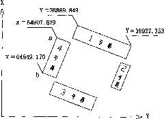
[0032] Before the construction unit makes the positioning measurement, it must obtain the general construction plan blueprint with the positioning measurement coordinates presented by the design institute. The blueprint must be approved by the owner. If there is any change, the design institute should revise the general drawing again, and it can be used only after it is finally confirmed to be correct.

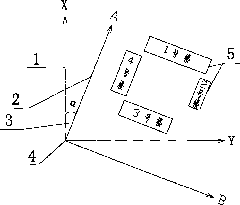
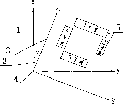
[0033] (2) Draw a rough planar relationship diagram between the survey coordinate system and the building:

[0034] According to the increasing direction of X value and Y value of measuring coordinates, determine the positive and negative directions of measuring coordinate system 1 in the blueprint of the general construction plan, and then draw a rough di...


PUM


Abstract

The invention relates to a method for performing inter-conversion between survey coordinates and construction coordinates. The method specifically comprises the following steps of: obtaining designed positioned survey coordinates of a building by a designing institute; converting all survey coordinates needing lofting through Excel software by using a computer, wherein a construction coordinate system conversion equation needs using in the conversion process of all the survey coordinates; converting the survey coordinates into coordinates which are parallel to and vertical to the building by using the construction coordinate system conversion equation, wherein the azimuth angle of a distance between two points on the same axis in the coordinate system is surely one of 0 degree, 90 degrees, 180 degrees and 270 degrees despite that the two points are on the same vertical axis or the same horizontal axis, and one of the values of the two points (A, B) on the same vertical axis or the same horizontal axis is surely the same; determining converted data into the construction coordinates after the converted data is verified as correct and lofting by using the construction coordinates. Due to the adoption of the method, a computing formula can be simplified, fast computation is realized and the correctness of a computed result is enhanced.

Description

technical field [0001] The invention belongs to the technical field of engineering measurement, and in particular relates to a mutual conversion method between measurement coordinates and construction coordinates. Background technique [0002] The traditional building positioning measurement method is: directly use the measurement coordinates provided by the design institute to carry out the measurement. Generally, there is a certain angle between the measurement coordinates and the vertical and horizontal axes of the building. In the process of setting out, it is often necessary to calculate two The azimuth and distance between the points are checked to ensure the accuracy of the data, so the calculation workload will be very large, which will inevitably have a certain adverse effect on the accuracy of the data. [0003] Therefore, it is necessary to develop a new building location measurement method. Contents of the invention [0004] The technical problem to be solved ...

Claims


Application Information

Patent Timeline
Patent Type & Authority Applications(China)
IPC IPC(8): G01B21/00
Inventor 桂祁东
Owner CHINA FIRST METALLURGICAL GROUP
Why Eureka
Try Eureka