Supercharge Your Innovation With Domain-Expert AI Agents!

GML document storage and enquiry method based on coordinate separation

A document storage and query method technology, applied in special data processing applications, instruments, electrical digital data processing and other directions, can solve the problem that GML data management cannot meet the needs of users.

Inactive Publication Date: 2010-09-22
TONGJI UNIV +1
View PDF4 Cites 4 Cited by
  • Summary
  • Abstract
  • Description
  • Claims
  • Application Information

AI Technical Summary

Problems solved by technology

However, the increasingly complex GIS applications make GML data management based on text format less and less able to meet the increasing needs of users

Method used


Image

  • GML document storage and enquiry method based on coordinate separation
  • GML document storage and enquiry method based on coordinate separation
  • GML document storage and enquiry method based on coordinate separation

Examples


Embodiment Construction

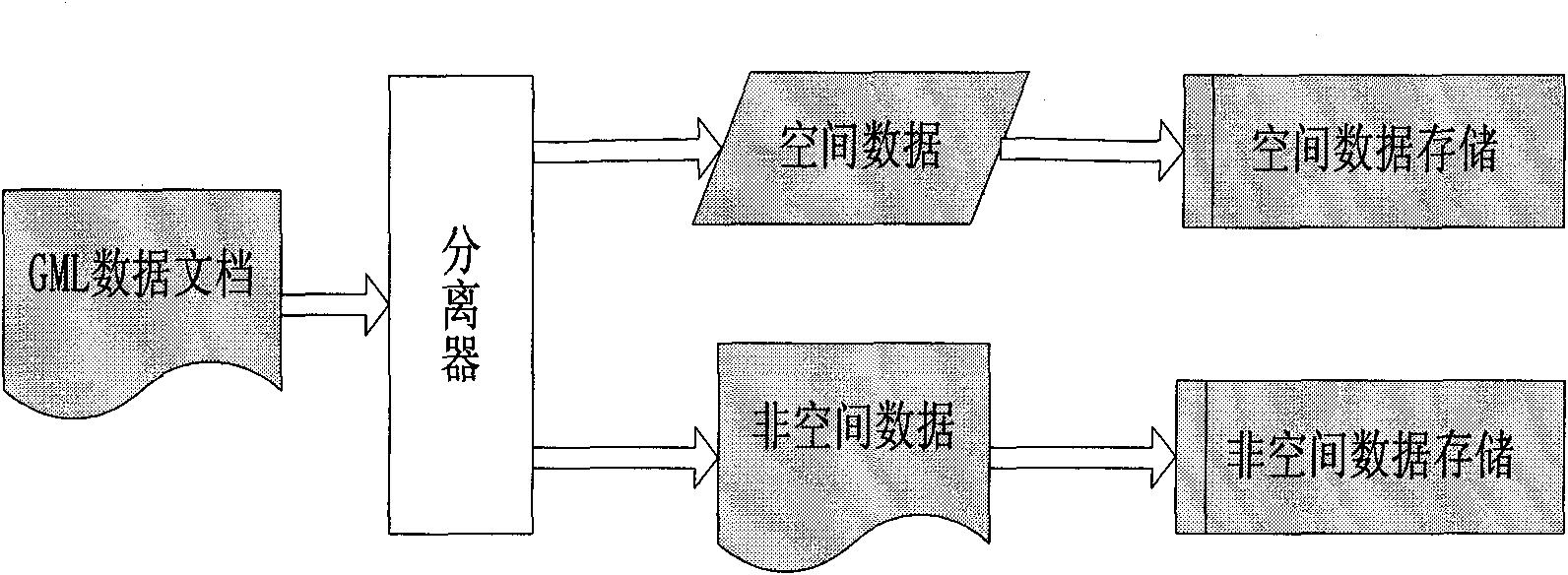
[0025] 1. Separation of data

[0026] The present invention utilizes the Xerces parser (SAX) provided by Apache to parse the GML document, and a series of event marks can be obtained by parsing, such as StartElement ( ), EndElement ( ), etc., and it is processed according to the needs of separation, and the spatial coordinates Data is separated from non-spatial coordinate numbers.

[0027] 2. Storage of non-spatial coordinate data

[0028] The present invention uses the storage technology of DB2 Pure XML to store and manage the separated GML data of non-spatial coordinates. As shown in Table 1, the DOCID field is used to store the numbering of the GML data document, the DOCNAME field is the name of the stored document, and the XMLDOCUMENT Fields are used to store GML data that does not contain spatial coordinates. DB2 PureXML is a component that adds Native XML support to the traditional database DB2, so that it not only has the mature concurrency control, security managemen...


PUM


Abstract

The invention relates to a GML document storage and enquiry method based on coordinate separation, belonging to the technical field of spatial information storage and enquiry in the information technology. By adopting an SAX analyzer, spatial coordinate data in a GML document is separated from non-spatial coordinate data. The separated data containing no spatial coordinates is stored in a database for DB2 pure XML of basic Native xml, the separated spatial data is stored in a DB2 spatial extender, and the spatial coordinate data and the non-spatial coordinate data are linked together through linking factors generated during data separation. When in enquiry, an enquiry statement is separated into two enquiry statements, i.e. a spatial enquiry statement and a non-spatial enquiry statement, and then enquiry operation is conducted. According to experiments, the GML data storage scheme based on spatial coordinate data separation is effective and feasible and can be used for effectively storing and managing GML document data.

Description

technical field [0001] The invention belongs to the technical field of spatial information storage and query in information technology, and in particular relates to a method for storing and querying geographically marked data (GML data). Background technique [0002] Geographic Information System (GIS for short) is becoming the support platform of more and more information systems in recent years. With the rapid development of the Internet and the widespread use of the Web, GIS has gradually evolved from a centralized system used by professionals to a distributed and networked massive information system. In recent years, the rapid emergence of mobile Internet and the rapid growth of mobile phone users have brought new opportunities for mobile spatial information services. The combination of GIS, GPS, RS, mobile Internet and mobile devices (mobile phones, PDAs, etc.) will enable people to access any spatial information at any time and any place by using mobile phones or othe...

Claims


Application Information

Patent Timeline
Patent Type & Authority Applications(China)
IPC IPC(8): G06F17/30
Inventor 关佶红王发标周水庚朱付保
Owner TONGJI UNIV
Features
  • R&D
  • Intellectual Property
  • Life Sciences
  • Materials
  • Tech Scout
  • Unparalleled Data Quality
  • Higher Quality Content
  • 60% Fewer Hallucinations
Learn More