
Method and system for showing communication traffic volume by combining Thiessen polygons and GIS map

A technology of GIS maps and Thiessen polygons, applied in wireless communication, electrical components, network planning, etc., can solve problems such as deviation and blank, circular or rectangular graphic units can not reflect the coverage of base stations, overlapping graphic units, etc., to achieve Beautiful interface, easy to view and interactive operation, simple form effect

Inactive Publication Date: 2010-10-27
ULTRAPOWER SOFTWARE
View PDF2 Cites 21 Cited by
  • Summary
  • Abstract
  • Description
  • Claims
  • Application Information

AI Technical Summary

Problems solved by technology

[0004] 1. Circular or rectangular graphic units cannot reflect the actual base station coverage, and there are deviations and blank spaces;
[0005] 2. The display effect is not very good. If a circle is used, there will be overlapping graphics units. If a rectangle is used, two base stations will fall in a rectangular unit. These special situations cannot be avoided by existing solutions;
[0006] 3. No matter which means of expression is used, it is too rough and far-fetched to describe the requirements professionally

Method used


Image

  • Method and system for showing communication traffic volume by combining Thiessen polygons and GIS map
  • Method and system for showing communication traffic volume by combining Thiessen polygons and GIS map

Examples


Embodiment Construction

[0026] The method and system for displaying communication traffic by combining Thiessen polygons with GIS maps proposed by the present invention are described as follows in conjunction with the accompanying drawings and embodiments.

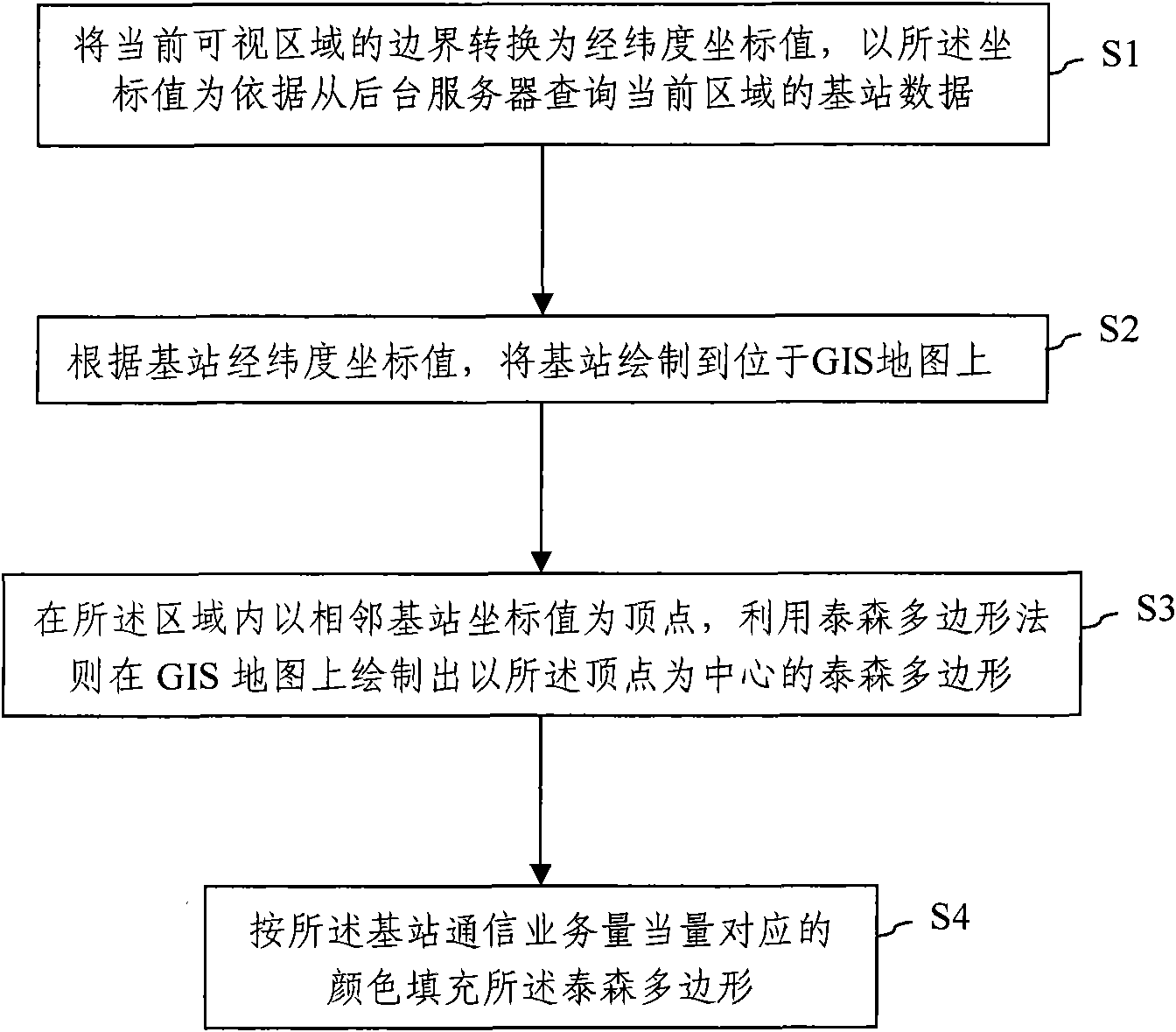
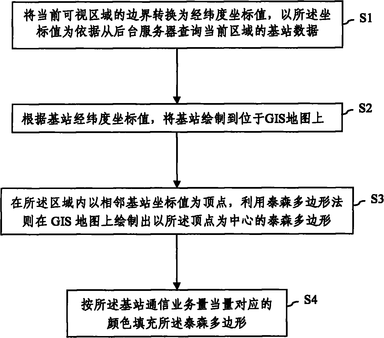
[0027] In this embodiment, the flash drawing method is used to draw the Thiessen polygon. Such as figure 1 As shown in the figure, it is a flow chart of the method of combining Thiessen polygons with GIS maps to display communication traffic according to the present invention. Step S1, converting the boundary of the visible area of ​​the current GIS map into latitude and longitude coordinate values, querying the base station data of the current area from the background server based on the coordinate values, wherein the base station data includes the latitude and longitude coordinate values ​​of the base station and the base station Absorb the volume of communication traffic (such as traffic volume) and the color corresponding to the equivalent v...


PUM


Abstract

The invention discloses a method for showing communication traffic volume by combining Thiessen polygons and a GIS map, which comprises the following steps: changing the boundaries of the visual area of the current GIS map into latitude and longitude coordinate values, and inquiring the base station data of the current area based on the coordinate values; drawing base stations on the GIS map based on the latitude and longitude coordinate values of the base stations; drawing multiple Thiessen polygons taking one base station as the center on the GIS map by using the coordinates of adjacent base stations in the area as the vertex and using the Thiessen polygon rule; and filling the Thiessen polygons with colors corresponding to the equivalent of the communication traffic volume of the center base station. The invention also discloses a system for showing communication traffic volume by combining Thiessen polygons and a GIS map, which comprises a base station data query module, a base station drawing module, a Thiessen polygon generating module and a Thiessen polygon filling module. The invention can precisely describe the practical coverage areas of the base stations, and the coverage areas of the base stations are mutually connected without overlaps or blank areas.

Description

technical field [0001] The invention relates to the technical field of traffic network management in the mobile communication industry, in particular to a method and system for displaying traffic volume by combining Thiessen polygons with GIS maps. Background technique [0002] In the field of traffic network management, in many cases, it is necessary to display the absorbed traffic volume within the coverage area of ​​each base station on the GIS map, so as to analyze the traffic volume distribution in a specific area. Most solutions use the base station as the center and draw solid circles with different radii in proportion to different traffic equivalents; or divide the region according to latitude and longitude, and draw an equally divided square grid. The cell is filled with different color levels represented by the traffic equivalent of the base station; the cell diagram is also processed similarly to the grid diagram, except that the quadrilateral is replaced by a hex...

Claims


Application Information

Patent Timeline
Patent Type & Authority Applications(China)
IPC IPC(8): H04W16/22H04W24/00
Inventor 李文智
Owner ULTRAPOWER SOFTWARE
Learn More