Method for calculating traffic condition by vehicle mounted GPS (Global Positioning System)

A global positioning system and traffic status technology, which is applied in the traffic control system of road vehicles, positioning, traffic flow detection, etc., can solve the problems of unpopular application, narrow search range, complex system structure, etc., and achieve a wide range of use and avoid Even car accidents, easy to popularize the effect of application

Inactive Publication Date: 2010-11-24
TOUCH MULTIMEDIA TECH SHANGHAI
View PDF3 Cites 10 Cited by
  • Summary
  • Abstract
  • Description
  • Claims
  • Application Information

AI Technical Summary

Problems solved by technology

[0006] 1, this prior art road traffic accident information collection and processing method is owing to adopting time variation index λ=(T 2 -T 1 / T 1 ) × 100%, making it difficult to apply, high cost, complex system structure, and cannot be widely used
[0007] 2. This prior art road traffic accident information collection and processing method makes the search range too narrow and not accurate enough because the search radius R is greater than or equal to 2000 meters

Method used


Image

  • Method for calculating traffic condition by vehicle mounted GPS (Global Positioning System)
  • Method for calculating traffic condition by vehicle mounted GPS (Global Positioning System)
  • Method for calculating traffic condition by vehicle mounted GPS (Global Positioning System)

Examples


Embodiment Construction

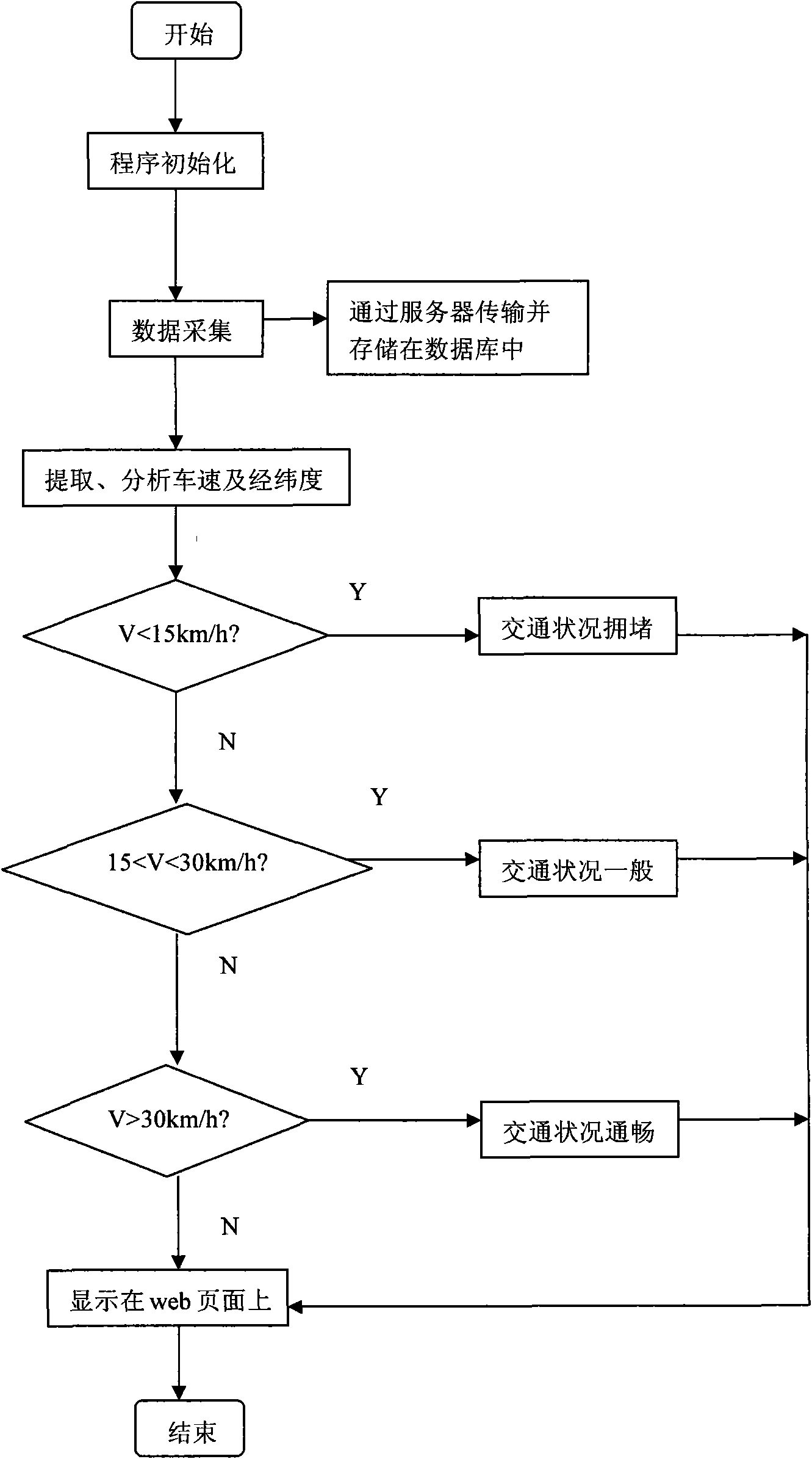
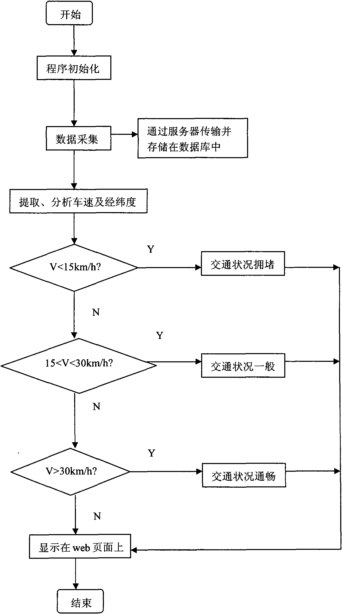
[0026] Please see attached figure 1 Shown, a kind of vehicle-mounted global positioning system (GPS) calculates the method for traffic condition, comprises the steps: step 1, the vehicle-mounted global positioning system (GPS) device that is arranged on the taximeter is opened; Step 2, system automatically The longitude and latitude of the current taxi location and the current driving speed are connected to the network by the Global System for Mobile Communications (GSM) and then transmitted to the server arranged in the dispatch center; step 3, the taxi position and speed information are passed through the vehicle-mounted global positioning system ( GPS) is transmitted to the server and stored in the database: step 3.1, the vehicle-mounted global positioning system (GPS) set on the taxi meter passes the information of the longitude and latitude of the location of all taxis and the current speed of the taxi through The Global System for Mobile Communications (GSM) is connected...


PUM


Abstract

The invention relates to a method for calculating traffic condition by a vehicle mounted GPS (Global Positioning System), comprising a taxi, a taximeter arranged on the taxi, a GPS arranged on the taxi taximeter and a server arranged in a dispatching center. In the method, the position and the speed of the taxi is connected to a network and transferred to the server by the GPS through a global mobile communications system; the position and the speed are stored in a database; and the server extracts and analyzes the data; all the taxis from a start to an endpoint on a road are counted through latitudes and longitudes obtained by the GPSs on the taxie; traffic jam is marked with red when the average speeds of all the taxis are below 15km; normal traffic is marked with yellow when the average speed of all the taxies are below 30 km and above 15 km; and smooth traffic is marked with green when the average speeds of all the taxis are above 30 km. The method for calculating traffic with the GPS is used for counting the traffic on all road sections, is simple to operate and can be started to count the traffic of a road.

Description

technical field [0001] The invention relates to a method for calculating traffic conditions, in particular to a method for calculating traffic conditions by a vehicle-mounted global positioning system (GPS). Background technique [0002] At present, a prior art multifunctional vehicle-mounted Bluetooth GPS system belongs to vehicle-mounted positioning equipment. This system includes GPS module and bluetooth module, one-chip computer with MP3 hardware decoder, liquid crystal display module, D / A conversion, audio amplifier chip and FM frequency modulation transmitter. Among them: the GPS module is connected with the single-chip microcomputer and the bluetooth module respectively, after the GPS module receives the latitude and longitude data, send them to the bluetooth module and the single-chip microcomputer respectively through two serial ports; The liquid crystal display module shows; the single-chip microcomputer has an MP3 hardware decoder, reads and decodes MP3 files, th...

Claims


Application Information

Patent Timeline
Patent Type & Authority Applications(China)
IPC IPC(8): G08G1/01G08G1/052G01S5/14
Inventor 刘思凯
Owner TOUCH MULTIMEDIA TECH SHANGHAI
Why Eureka
Try Eureka